Ziethe
| Ziethe | ||
|
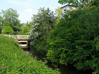
The Ziethe in the north of the city of Köthen (Anhalt), bridge between the streets Am Dreiangel and the Güterseeweg. |
||
| Data | ||
| location | State of Saxony-Anhalt , south between Dessau and Bernburg , north of Halle , central point is the city of Köthen (Anhalt) | |
| River system | Elbe | |
| source | at Scheuder 51 ° 46 ′ 0 ″ N , 12 ° 4 ′ 57 ″ E |
|
| Source height | approx. 73 m above sea level NN | |
| muzzle | near Plömnitz in the Fuhne coordinates: 51 ° 44 ′ 30 ″ N , 11 ° 48 ′ 17 ″ E 51 ° 44 ′ 30 ″ N , 11 ° 48 ′ 17 ″ E |
|
| Mouth height | approx. 62 m above sea level NN | |
| Height difference | approx. 11 m | |
| Bottom slope | approx. 0.44 ‰ | |
| length | 25 km | |
| Navigable | No | |
The Ziethe is a tributary of the Fuhne in the Anhalt-Bitterfeld district with a total length of around 25 kilometers.
geography
course
The headwaters of the Ziethe are located on the south-eastern outskirts of Scheuder , a district of the unified municipality of the City of Southern Anhalt . The watershed caused by a slight slope of the ditch allows the stream to flow in different directions ( bifurcation ): to the east, where the Ziethe flows into the Libbesdorfer Landgraben after a short time , and to the west, where it flows through several localities in the Köthener Land, the north of the Passed the district town of Köthen (Anhalt) and finally flows into the Fuhne near Plömnitz ( Preußlitz ).
Cities and communities on the Ziethe
- Scheuder
- Libbesdorf
- Merzien
- Zehringen
- Koethen (Anhalt)
- Großpaschleben
- Zabitz
- Trinum
- Kleinpaschleben
- Cruchchers
- Wohlsdorf
- Biendorf
- Plömnitz
Web links
- Ziethequelle at Scheuder
- Mitteldeutsche Zeitung "A green spot on earth" , September 3, 2010

