Scheuder
|
Scheuder
City of southern Anhalt
Coordinates: 51 ° 46 ′ 6 " N , 12 ° 4 ′ 42" E
|
||
|---|---|---|
| Height : | 73 m above sea level NN | |
| Area : | 9.8 km² | |
| Residents : | 180 (Apr 13, 2016) | |
| Population density : | 18 inhabitants / km² | |
| Incorporation : | January 1, 2010 | |
| Postal code : | 06386 | |
| Area code : | 034977 | |
|
Location of Scheuder in Saxony-Anhalt |
||
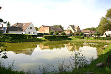
Scheuder is a district of the city of Southern Anhalt in the Anhalt-Bitterfeld district in Saxony-Anhalt .
geography
The village of Scheuder is located between the district town of Köthen (Anhalt) and Dessau-Roßlau .
history
Scheuder was first mentioned in a document in 1314 .
Until the formation of the unitary community of Southern Anhalt on January 1, 2010, Scheuder was an independent community in the administrative community of Southern Anhalt with the associated districts Lausigk (incorporated into Scheuder on October 1, 1961) and Naundorf (incorporated into Lausigk on July 1, 1950). The last mayor of Scheuder was Franz Riemer.
Memorials
- Tombs in the cemetery of the local part Lausigk for Yugoslav prisoners of war and three known by name Soviet citizens and the toddler a Polish woman who during the Second World War deported to Germany and victims of forced labor were
Attractions
- Scheuder Church
- Historical "Scheuderscher Gasthof"
Transport links
The federal highway 185 runs north of the community from Dessau-Roßlau to Köthen (Anhalt) .
Personalities
- Franz von Fleischer (1801–1878), botanist
- Christian Stein (1809–1887), pastor in Scheuder from 1846 to 1856


