Meilendorf
|
Meilendorf
City of southern Anhalt
Coordinates: 51 ° 43 ′ 11 " N , 12 ° 5 ′ 44" E
|
||
|---|---|---|
| Height : | 84 m above sea level NN | |
| Area : | 7.89 km² | |
| Residents : | 75 (Apr 13, 2016) | |
| Population density : | 10 inhabitants / km² | |
| Incorporation : | January 1, 2010 | |
| Postal code : | 06386 | |
| Area code : | 034977 | |
|
Location of Meilendorf in Saxony-Anhalt |
||
Meilendorf with the districts Meilendorf, Zehmigkau and Körnitz is a town in the city of Southern Anhalt in the district of Anhalt-Bitterfeld in Saxony-Anhalt .
geography
Meilendorf lies between Köthen (Anhalt) and Halle (Saale) .
history
In 1160 Meilendorf was first mentioned as Milice .
On July 1, 1950, the previously independent communities Körmitz and Zehmigkau were incorporated.
Until the new formation of the unified community of Southern Anhalt on January 1, 2010, Meilendorf was an independent community in the administrative community of Southern Anhalt with the associated districts of Zehmigkau and Körnitz. The last mayor of Meilendorf was Britta Friedrich.
Culture and sights
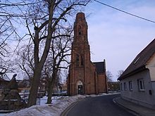
The cruciform church from 1879 in the district of Meilendorf was damaged in the Second World War and needs extensive renovation.
The former transformer tower in the Körnitz district has been used as a species protection tower since 1994. Since its reconstruction in 2005 based on original plans from 1914, the Körnitzer Owl Tower has been the destination of numerous bike tours. Barn owls and kestrels nest here regularly.
Transport links
West of Meilendorf, the federal highway 183 runs from Bitterfeld-Wolfen to Köthen (Anhalt) .

