Key Haven, Florida: Difference between revisions
m →References: stub sorting using AWB |
m Wikilink |
||
| Line 2: | Line 2: | ||
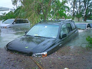
[[Image:Flood102405.JPG|thumb|right|300px|Flooding caused by [[storm surge]] from [[Hurricane Wilma]] on Key Haven, 10/24/2005 <font color="ffffff">Photo: Marc Averette</font>]] |
[[Image:Flood102405.JPG|thumb|right|300px|Flooding caused by [[storm surge]] from [[Hurricane Wilma]] on Key Haven, 10/24/2005 <font color="ffffff">Photo: Marc Averette</font>]] |
||
'''Key Haven''' is an [[unincorporated area|unincorporated]] community on Raccoon Key, an island in the lower [[Florida Keys]] about a mile east of the island of [[Key West]]. It is a suburb of greater Key West, and houses approximately a thousand residents. The city limits of Key West on northern [[Stock Island]] are separated from Key Haven by a channel about a quarter mile wide. |
'''Key Haven''' is an [[unincorporated area|unincorporated]] community on [[Raccoon Key]], an island in the lower [[Florida Keys]] about a mile east of the island of [[Key West]]. It is a suburb of greater Key West, and houses approximately a thousand residents. The city limits of Key West on northern [[Stock Island]] are separated from Key Haven by a channel about a quarter mile wide. |
||
It is off of the northeast side of Stock Island, and connected by fill to [[U.S. Route 1 in Florida|U.S. 1]] (the [[Overseas Highway]]) via Key Haven Road, its primary road, just east of mile marker 5. |
It is off of the northeast side of Stock Island, and connected by fill to [[U.S. Route 1 in Florida|U.S. 1]] (the [[Overseas Highway]]) via Key Haven Road, its primary road, just east of mile marker 5. |
||
Revision as of 17:15, 15 March 2010


Key Haven is an unincorporated community on Raccoon Key, an island in the lower Florida Keys about a mile east of the island of Key West. It is a suburb of greater Key West, and houses approximately a thousand residents. The city limits of Key West on northern Stock Island are separated from Key Haven by a channel about a quarter mile wide.
It is off of the northeast side of Stock Island, and connected by fill to U.S. 1 (the Overseas Highway) via Key Haven Road, its primary road, just east of mile marker 5.
Key Haven was chosen as the location of The Real World Key West, which appeared in 2006.[1] The Real World home is located at the end of Driftwood Drive.[2]
The island being only 2-3 ft above the high tide mark, was literally covered with 4-5 ft of seawater from the 8 ft (2.4 m) storm surge of Hurricane Wilma on October 24, 2005. Just about every car on the island was destroyed, and many homes damaged.
References
24.582173°N -81.735535°E / 24.582173°N 81.735535°W Coordinates: longitude degrees < 0 with hemisphere flag
{{#coordinates:}}: invalid longitude

