
History of Milton Keynes
The History of Milton Keynes details the development of Milton Keynes, from the earliest human settlements, through the plans for a 'new city' in North Buckinghamshire and its subsequent urban design and development by the Milton Keynes Development Corporation, to its subsequent development to the present day.
On 23 January 1967 when the designation order[1] was made, the area to be developed (some 8,851hectares/21,833acres) was largely farmland and undeveloped villages. Before construction began, every area was subject to detailed archaeological investigation: doing so has provided a unique insight into the history of a large sample of the landscape of south-central England.
Pre-history
Long before England came to exist, this area was at the bottom of a primeval sea. The most notable of the fossils uncovered is that of an ichthyosaur from Caldecotte. It is now on display in the central library.
Early human settlement

Settlement began in this area around 2000BCE, mainly in the valleys of the rivers Ouse and Ouzel and their tributaries (Bradwell Brook, Shenley Brook). Archaeogical excavations discovered several burial sites dating from 2000BCE to 1500BCE. Evidence for the earliest habitation was found[2] at Blue Bridge — production of flint tools from the Middle Stone Age. In the same area, an unusually large (18 metre diameter) round house was ecavated[3] and dated to the Late Bronze Age/Early Iron Age, about 700BCE. Other excavations in this Blue Bridge/Bancroft hill-side uncovered a further seven substantial settlement sites, dating from then until 100BCE.
The area that was to become Milton Keynes was relatively rich: possibly the largest (by weight) hoard of Iron Age jewellery ever found in Britain ("the Milton Keynes Hoard") was discovered[4] in Monkston (near Milton Keynes village) and consists of two Saxon era gold torcs and three gold bracelets.[5][6]
Roman Britain
Before the Roman conquest of Britain of 43CE, the Catuvellauni tribe controlled this area from their hill fort at Danesborough, near Woburn Sands (map). Under Roman occupation, the area appears to have thrived. The most obvious reason for this is their construction of Watling Street through the area and the associated town at Magiovinium (Fenny Stratford). The foundations of a large Romano-British villa were excavated at Bancroft Park, complete with under-floor heating and mosaic floor. Archaeological excavations revealed that this site (map), overlooking the fertile valley of the Bradwell Brook, was in continuous occupation[7] for 2000 years, from the Late Bronze Age to the early Saxon period. Cremation grave goods from the Iron Age found on the site included jewellery and fine pottery. Other Romano-British settlements were found at Stantonbury, Woughton and Wymbush. Industrial activity of the period included bronze working and pottery making at Caldecotte, pottery also at Wavendon Gate, and many iron-working sites.
Anglo-Saxon period
It seems that many of the Romano-British sites were abandoned by the fifth century and the arable land reverted to scrub and woodland. Arriving in the sixth century, the Anglo-Saxons began to clear the land again. Bletchley ("Blaeca's clearing") and Shenley ("Bright clearing") date from this period. Large settlements have been excavated at Pennyland and near Milton Keynes Village. Anglo-Saxon cemeteries have been found at Newport Pagnell, Shenley and Tattenhoe.[8]
Norman conquest and the medieval period
Excavations in and around the modern villages have failed to find any evidence of occupation before the 10th or 11th centuries, with the exception of Bradwell, where Bradwell Bury is traced to the 9th century. The Domesday Book of 1086 provides the first documentary evidence for many settlements, listing Bertone (Broughton), "Calvretone" (Calverton), Linforde (Linford), Lochintone (Loughton), Neuport (Newport Pagnell), Nevtone (Newton Longville), Senelai (Shenley), Siwinestone (Simpson), Ulchetone (Woughton), Waletone (Walton), Wluerintone (Wolverton) and Wlsiestone (Woolstone).
Administration of the area was in "Hundreds". The northern and central parishes (Calverton, Wolverton, Bradwell, Bradwell Abbey, Stantonbury, Great Linford, Newport Pagnell, Willen, The Woolstones, part of Shenley Church End, Loughton, Woughton and Simpson) were in Secklow Hundred; those east of the River Ouzel (Moulsoe, Broughton, Milton Keynes village, Wavendon, Walton and part of Bow Brickhill) were in Moulsoe Hundred; those to the south and west of Watling Street (the southern part of Shenley Church End, Shenley Brook End, Tattenhoe, Bletchley, Fenny Stratford, Newton Longville, Water Eaton) were in Mursley Hundred. The moot mound of Secklow Hundred has been found, excavated and reconstructed — it is on the highest point in the central area and is just behind the Library in modern Central Milton Keynes. Only one medieval manor house survives: the 15th century Manor Farmhouse in Loughton. There are sites of other manor houses in Great Woolstone, Milton Keynes village and Woughton on the Green. The oldest surviving domestic building is Number 22, Milton Keynes (village), the house of the bailiff of the manor of Bradwell.[8] (In a later reorganisation of the Hundreds, Newport Hundred was created to absorb the earlier hundreds: it is almost exactly coterminous with the modern Borough of Milton Keynes
Newport Pagnell, established early in the 10th century, was the principal market town for the area. Stony Stratford and Fenny Stratford were founded as market towns on Watling Street in the late 12th/early 13th centuries.
By the early 1200s, North Buckinghamshire had several religious houses: Bradwell Abbey (1154[9]) is within modern Milton Keynes and Snellshall Priory (1218[10]) is just outside the boundary beside Whitney. Both were Benedictine priories. Many of the medieval trackways to these sites still survive and have become cycleways and footpaths of the Redway network.

Britain's earliest[8] windmill to be excavated is in Great Linford. The large oak beams forming the base supports still survived in the mill mound and were shown by radio carbon dating to originate in the first half of the 13th century. (The present stone tower mill at Bradwell was built in 1815, on a site convenient to the new Grand Junction Canal).
Early modern Britain and the Industrial Revolution
Enclosures
Most of the eighteen medieval villages in Milton Keynes are still extant and are at the heart of their respective districts. But some, such as Old Wolverton, remain only as field patterns marking a deserted village. The desertion of Old Wolverton was due to enclosure of the large strip cultivation fields into small "closes" by the local landlords, the Longville family, who turned arable land over to pasture. By 1654, the family had completely enclosed the parish. With the end of the feudal system, the peasants had lost their land and tillage/grazing rights and were forced to find other work or starve. Thus Old Wolverton was reduced from about thirty peasant families in the mid 1500s to almost none, within the space of a century.[11]
There are also deserted village sites in Tattenhoe and Westbury (Shenley Wood).
Turnpike roads
Some important roads cross the site of the new city. Most important of these is Watling Street from London to Chester (the modern A5). Originally, the Northampton to London road joined the Watling Street at Fenny Stratford, via Broughton and Simpson. The Oxford to Cambridge route (modern A422) came through Stony Stratford, Wolverton and Newport Pagnell. Unfortunately, the heavy clay soils, poor drainage and many streams made these routes frequently impassable in winter. The Hockliffe to Dunchurch stretch of Watling Street became a Turnpike in 1706[12] [the first turnpike to be approved by parliament] and the route through Fenny Stratford, Loughton and Stony Stratford was paved . Simpson remained a quagmire[13] and in 1870[12] the new Northampton/London turnpike diverted away at Broughton to take the higher route through Wavendon and Woburn Sands to join Watling Street near Hockliffe. On the east/west route, the Stony Stratford to Newport Pagnell turnpike of 1814[12] extended the Woodstock, Oxfordshire/Bicester/Stony Stratford turnpike of 1768.[12] Turnpikes proved to be a major boost to the economy of Fenny Stratford and particularly Stony Stratford. In the stage coach era, Stony Stratford was a major resting place and exchange point with the east/west route. In the early 1800s, as many as 250 coaches a day stopped here. That traffic came to an abrupt end in 1838 when the London - Birmingham Railway (now the West Coast Main Line) was opened at Wolverton.
Grand Junction Canal
The Grand Junction Canal came through the area between 1793 and 1800, with canal-side wharfs in Fenny Stratford, Great Linford, Bradwell and Wolverton. The route bypassed Newport Pagnell but, in 1817, an arm was dug from Great Linford. Trade along the canal stimulated the local economy. A large brickworks was established near the canal in Great Linford: two bottle kilns and the clay pits can still be seen on the site. Pottery from the midlands begins to appear in excavations of dwellings from that period.
London and Birmingham Railway, Wolverton and New Bradwell new towns
The London and Birmingham Railway brought even more profound changes to the area. The coach trade on the turnpike through Stony Stratford collapsed, taking many businesses with it. Fortunately, Wolverton was the half way point on the route, where engines were changed and passengers alighted for refreshments. Wolverton railway works was established here, creating work for thousands of people in the surrounding area. In the period 1840 to 1880, new towns were built in New Bradwell and Wolverton (about 2km east of the original deserted village) to house them. A narrow gauge railway was built to Newport Pagnell in 1866, much of it by closing and reusing the Newport Arm of the canal. The Wolverton and Stony Stratford Tramway ran to Stony Stratford from 1888 (to 1926) and, in 1889, was extended to Deanshanger in Northamptonshire.
Bletchley, on the 1846 junction of the London and Birmingham railway with the Bedford branch, was to become an important railway town too. In 1850, another branch from Bletchley to Oxford was built, laying the foundations of the future (Cambridge/Oxford) Varsity Line. Bletchley, originally a small village in the parish of Fenny Stratford, grew to reach and absorb its parent.
In Stony Stratford, expertise learned in the Works was applied to the construction of traction engines for agricultural use and the site of the present Cofferidge Close was engaged in their manufacture.
Bletchley Park

Bletchley Park, also known as Station X, is a former private estate located in Old Bletchley and modern Museum of Cryptography. Conveniently located at the junction of the Varsity Line with the West Coast Main Line, Bletchley Park was the location of the United Kingdom's main codebreaking establishment during World War II. Codes and ciphers of several Axis countries were deciphered there, most famously the German Enigma. The high-level intelligence produced by Bletchley Park, codenamed Ultra, is frequently credited with aiding the Allied war effort and shortening the war, although Ultra's effect on the actual outcome of WWII is debated.
"Bigger, Better, Brighter" — Bletchley in the 20th Century
Almost forty years after the construction of Bletchley railway station, the 1884/5 Ordnance Survey shows[14] Bletchley as still just a small hamlet around the C of E church at Bletchley Park, and another near the Methodist chapel and Shoulder of Mutton public house at the junction of Shenley Rd/Newton Rd with Buckingham Rd. (These hamlets are known today as 'Old Bletchley' and 'Far Bletchley'). The major settlement of the time is Fenny Stratford.
By 1911, the population of the combined parishes was 5,166[15] but the balance between them had changed: in that year, the name of the local authority (Urban District) changed from Fenny Stratford UD to Bletchley UD. The 1926 Ordnance Survey shows the settlements beginning to merge, with large private houses along the Bletchley Road between them. In 1933, the newly founded Bletchley Gazette began a campaign for a 'Bigger, Better, Brighter, Bletchley'.[16] As the nation emerged from war, Bletchley Council renewed its desire to expand from its 1951 population of 10,919. By mid 1952, the Council was able to agree terms with five London Boroughs to accept people and businesses from bombed-out sites in London.[17] This trend continued through the 50s and 60s, culminating[18] in the GLC-funded Lakes Estate in Water Eaton parish, even as Milton Keynes was being founded. Industrial development kept pace, with former London businesses relocating to new industrial estates in Mount Farm and Denbigh — Marshall Amplification being the most notable. With compulsory purchase, Bletchley Road (now renamed Queensway after a royal visit in 1966) became the new high street with wide pavements where front gardens once lay. Houses near the railway end were replaced by shops but those nearer Fenny Stratford became banks and professional premises. At the 1971 Census, the population of the Urban District was 30,642.[19]
Bletchley had fought to be the centre of the proposed new city, but it was not to be. The 1971 Plan for Milton Keynes placed Central Milton Keynes on a completely new hill-top site four miles further north, half way to Wolverton. Bletchley was relegated to the status of suburb.
1960s Plans for a new city in North Buckinghamshire, 1967 designation of Milton Keynes
In the 1960s, the Government decided that a further generation of new towns in South East England was needed to take the projected population increase of London, after the initial 1940s/1950s wave. Bletchley had already been considered as a new town in this first wave, and had subsequently in the 1950s the London County Council constructed overspill housing for several London boroughs there.[20][21][22]
In 1964, a Ministry of Housing and Local Government study in 1964[23] recommended "a new city" near Bletchley. A further MoH&LG study[24][25] in 1965 proposed that the proposed new city would encompass the existing towns of Bletchley, Stony Stratford and Wolverton. It was to be the biggest new town yet, with a with a target population of 250,000.[26] A Draft Order was made in April 1966.
The Housing Minister, Anthony Greenwood, made his formal announcement of the final area on the 23rd of January 1967.[27][28] The designated area was 25,200 acres, smaller than the 27,000 acres in the Draft Order; with the exclusion of Calverton. The name "Milton Keynes" was also unveiled at this time, taken from the existing village of Milton Keynes on the site.
The site was deliberately located equidistant from London, Birmingham, Leicester, Oxford and Cambridge with the intention[citation needed] that it would be self-sustaining and eventually become a major regional centre in its own right. With its large target population, Milton Keynes was eventually intended to become a city.[29] All subsequent planning documents and popular local usage make use of the term "city" or "new city", even though formal city status has not been awarded.
When the boundary of Milton Keynes was defined, some 40,000 people [30] lived in the "designated area" of 8,851ha/21,833a. The area was split between five existing local authorities: Bletchley, Newport Pagnell and Wolverton urban districts and also the Newport Pagnell Rural District and the Winslow Rural District. Planning control was taken from elected local authorities and delegated to the Milton Keynes Development Corporation (MKDC).
Existing settlements and oral history
The designated area outside the four main towns (Bletchley, Newport Pagnell, Stony Stratford, Wolverton) was largely rural farmland but included many picturesque North Buckinghamshire villages and hamlets: Bradwell village and Abbey, Broughton, Caldecotte, Fenny Stratford, Great Linford, Loughton, Milton Keynes Village, New Bradwell, Shenley Brook End, Shenley Church End, Simpson, Stantonbury, Tattenhoe, Tongwell, Walton, Water Eaton, Wavendon, Willen, Great and Little Woolstone, Woughton on the Green
The CLUTCH Club Milton Keynes site holds a collection of archival photos and recorded interviews compiled by residents of the older towns and villages incorporated within Milton Keynes. Larger MK-related oral history collections have been created at The Living Archive, and a broader family of sites and links to archeological studies of the Milton Keynes area is maintained by the Milton Keynes Heritage Association, which "exists to encourage and develop cooperation and coordination between all members having an interest in heritage within the Milton Keynes district."
Milton Keynes Development Corporation: designing a city for 200,000 people
Following publication of the Draft Master Plan for Milton Keynes, the government appointed Lord Campbell of Eskan ("Jock" Campbell) to lead the Milton Keynes Development Corporation. He and his Chief Executive, Walter Ismay, appointed Llewellyn-Davies as principal planning consultants — the team included Richard Llewellyn-Davies, Walter Bor and John de Monchaux. The goals declared in the master plan were these:
- opportunity and freedom of choice
- easy movement and access
- good communications
- balance and variety
- an attractive city
- public awareness and participation
- efficient and imaginative use of resources
The Corporation's strongly modernist designs featured regularly in the magazines Architectural Design and the Architects' Journal. MKDC was determined to learn from the mistakes made in the earlier New Towns and revisit the Garden City ideals. They set in place the characteristic grid roads that run between districts and the intensive planting, lakes and parkland that are so appreciated today. Central Milton Keynes was not intended to be a traditional town centre but a business and shopping district that supplemented the Local Centres in most of the Grid Squares.[31] This non-hierarchical devolved city plan was a departure from the English New Towns tradition and envisaged a wide range of idustry and diversity of housing styles and tenures across the city. The largest and almost the last of the British New Towns, Milton Keynes has stood the test of time far better than most, and has proved flexible and adaptable. The radical grid plan was inspired by the work of Californian urban theorist Melyvn Webber (1921-2006), who the founding architect of Milton Keynes, Derek Walker, described as the city's "father". Webber thought that telecommunications meant that the old idea of a city as a concentric cluster was out of date and that cities which enabled people to travel around them readily would be the thing of the future achieving "community without propinquity" for residents. With both car ownership and ever more emphasis on e-commerce, his ideas, launched in the 1960s, have proved far-sighted, rarely more so than in Milton Keynes.
Urban design
Since the radical plan form and large scale of the New City attracted international attention, early phases of the city include work by celebrated architects, including (Sir) Richard MacCormac, (Lord) Norman Foster, Henning Larsen, Ralph Erskine, John Winter, and Martin Richardson.[32] The Corporation itself attracted talented young architects led by the young and charismatic Derek Walker. Though strongly committed to sleek "Miesian" minimalism inspired by the German/ American architect Ludwig Mies van der Rohe they also developed a strand of contextualism in advance of the wider adoption of commerical Post-Modernism as an architectural style in the 1980s. In the Miesian tradition were the Pineham Sewage Works, which Derek Waler regarded as his finest achievement, and the Shopping Building designed by Stuart Mosscrop and Christopher Woodward, which is widely regarded as the finest C20 retail building in Britain (due for major redevelopment in 2007, following the failure of attempts to have it protected as a Listed building). The contextual tradition that ran alongside it is best exemplified by the Coproration's infill scheme at Coffereidge Close, Stony Stratford, designed by Wayland Tunley, which carefully inserts into a historic stretch of High Street a modern retail facility, offices and car park. The Development Corporation also led an ambitious public art programme.
"City in the forest"
The original Development Corporation design concept aimed for a "forest city" and its foresters planted millions of trees from its own nursery in Newlands in the following years. As of 2006, the urban area has 20 million trees. Following the winding up of the Development Corporation the lavish landscapes of the Grid Roads and of the major parks were transferred to the MK Parks Trust, a non-profit charity which is quite seperate from the municipal authority and which was intended to resist pressures to build on the parks over time. The Parks Trust is endowed with a portfolio of commerical properties, the income of which pay for the upkeep of the green spaces, a city-wide maintainance model which has attracted international attention.[33]
Public art

The Development Corporation had an ambitious public art programme and over 50 works were commissioned, mostly still extant. This programme also had two strands: a populist one which invovled the local community in the works, the most famous of which is Liz Leyh's Concrete Cows, a group of concrete Friesian cows which have become the unofficial logo of the city; and a tradition of abstract gemoetrical art, the finest of which is Lilliane Lijn's elegant "Circle of Light" hanging in the Midsummer Arcade of the Shopping Building, Central Milton Keynes (though its mechanism has not worked for many years, it is striking as a static work).
Demographics
Unusually for a new town, Milton Keynes has arrived at a bias in favour of private sector investment, with a majority of owner-occupied homes. The political climate determined this: previous new towns were mainly controlled by Labour Governments but Milton Keynes was mainly built during the Conservative years.
"Milton Keynes is dying for a hospital"
By the middle of the 1970's there was still no local hospital. A campaign under the banner Milton Keynes is Dying for a Hospital was started, which resulted in the commitment to build a hospital on the current Eaglestone site.
Shortage of resources made it apparent that the main hospital with acute services would not be built until the early 1980's, and so a "stop-gap" Community Hospital was built, which opened in 1979. This consisted of four wards, including one for acute mental illness care, a rehabilitation department, a small x-ray department, and a few other supporting services, e.g. estates, catering and portering. The Community Hospital was built adjacent and linked to the Eaglestone Health Centre, which was the first health care building on site in 1977-78. Milton Keynes General Hospital finally opened in 1984.
Milestones since 1967
1960s
1961 Census: Population of districts to become[34] the Borough of Milton Keynes = 52,931
- 1967 Designation
- 1969 The Open University moves to its new headquarters in Walton Hall.
1970s
- 1970 First section of new city grid road system (H2 from V4 Watling Street).
- 1971 First major housing scheme (Galley Hill, Stony Stratford).
1971 Census: Population of future Borough of Milton Keynes = 66,949;
 population of designated area = 46,500
- 1974 Stantonbury Campus opens; first major grid road (V8 Marlborugh Street connects Bletchley to Stantonbury (for New Bradwell and Wolverton); work begins on the Shopping Building (now The Centre:MK); the first balancing lake (Willen Lake) is finished.
- 1975 The first office building in Central Milton Keynes (Lloyds Court) opens.
- 1979 First concert at Milton Keynes Bowl (Desmond Dekker/Geno Washington); Margaret Thatcher opens opens the Shopping Building.
1980s
-
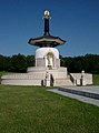 Peace Pagoda, 1980
 -
 Milton Keynes Central and Station Square, 1882
 -
 Energy World, 1986
 -
 Bradwell aqueduct, 1989


- 1980 A5D opens, bypassing Watling Street; Peace Pagoda dedicated at Willen.
- 1981 Homeworld, Central Library, Willen Hospice
1981 Census: Population of future Borough of Milton Keynes = 123,289;
 population of designated area 95,800
- 1982 Central Milton Keynes railway station officially open.
- 1983 Caldecotte balancing lake ready.
- 1984 A421 road connects to M1 motorway at Junction 13; Milton Keynes General Hospital opens.
- 1985 Britains first 10 screen multiplex cinema, The Point, opens.
- 1986 Energy World ; new County Court; Forte Crest Hotel (now Holiday Inn); Gyosei school
- 1987 Woughton Marina opens.
- 1989 Furzton balancing lake, Bradwell aqueduct (first aqueduct on Grand Union in over 100 years).
1990s
-
 Ecumenical Church of Christ the Cornerstone
 -
Milton Keynes Gallery, surface by Michael Craig-Martin

1991 Census: Population of future Borough of Milton Keynes = 179,252;
 population of designated area = 144,700.
- 1991 Ecumenical Church of Christ the Cornerstone was completed; De Montfort University opens Milton Keynes campus. (Closes 2003).
- 1992 Milton Keynes Development Corporation wound up, replaced by Commission for New Towns; Kingston District Centre; Woodhill (HM Prison).
- 1994 Westcroft district centre.
- 1996 National Hockey Stadium.
- 1997 Borough of Milton Keynes unitary authority
- 1999 Milton Keynes Theatre, Art Gallery and new Visitor Centre.
2000s
- 2000 Xscape opens.
2001 Census: Population of Borough of Milton Keynes = 207,063;
 population of designated area = 177,500.
- 2003 Wimbledon F.C. moves to the National Hockey Stadium.
- 2004 ("XXIV") Wimbledon F.C. renamed and relaunched as Milton Keynes Dons F.C..
Further development plans
In January 2004, Deputy Prime Minister John Prescott announced[35] the United Kingdom government's Expansion plans for Milton Keynes
He proposed that the population of Milton Keynes should double in the subsequent 20 years. He appointed English Partnerships to do so, taking planning controls away from Milton Keynes Borough Council and making EP the statutory planning authority. In turn, EP established a subsidiary Milton Keynes Partnership to manage the programme locally. Their proposal for the next phase of expansion moves away from grid squares to large scale, mixed use, higher density developments which are more based on public transport than private car usage.
Bibliography
- Markham: A History of Milton Keynes and District (two volumes)
- Croft and Mynard: The Changing Landscape of Milton Keynes ISBN 0-949003-12-3
- Mynard and Hunt: Milton Keynes, a pictorial history ISBN 0-85033-940-5
- Clapson: A Social History of Milton Keynes, Middle England/Edge City ISBN 0-7146-8417-1
- Croft and Mynard: The Changing Landscape of Milton Keynes Buckinghamshire Archaeological Society, Monograph Series
- Zeepvat, Roberts and King: Caldecotte, Milton Keynes - Excavations and Fieldworks 1966-91 Buckinghamshire Archaeological Society, Monograph Series
- Mynard and Zeepvat: Excavations at Great Linford 1974-80 Buckinghamshire Archaeological Society, Monograph Series
- Williams: Pennyland and Hartigans - Two Iron Age and Saxon sites in Milton Keynes Buckinghamshire Archaeological Society, Monograph Series
- Marney: Roman & Belgic Pottery - From Excavations in Milton Keynes 1972-82 Buckinghamshire Archaeological Society, Monograph Series
- Ivens, Busby and Shepherd: Tattenhoe and Westbury - Two Deserted Medieval Settlements in Milton Keynes Buckinghamshire Archaeological Society, Monograph Series
- Williams, Hart and Williams: Wavendon Gate - A Late Iron Age and Roman settlement in Milton Keynes Buckinghamshire Archaeological Society, Monograph Series
- Williams and Zeepvat: Bancroft - a late Bronze Age/Iron Age Settlemement, Roman Villa and Temple Mausoleum Buckinghamshire Archaeological Society, Monograph Series
- Mynard: Excavations on medieval sites in Milton Keynes Buckinghamshire Archaeological Society, Monograph Series
- "New Towns" Academy Editions London (1994) ISBN 1-85490-245-8 reprinted from Architectural Design Magazine.
- http://ocw.mit.edu/OcwWeb/Urban-Studies-and-Planning/11-123Big-PlansSpring2003/StudyMaterials/index.htm : an MIT OpenCourseware lecture by Professor John de Monchaux, one of the original lead design consultants for Llewellyn Davies
References
- ^ The "North Buckinghamshire (Milton Keynes) New Town (Designation) Order", London Gazette, January 24, 1967, page 827.
- ^ "Archaeology in the Milton Keynes District: Stone Age". Milton Keynes Heritage Association. Retrieved 2007-01-03.
- ^ "Archaeology in the Milton Keynes District: Bronze Age". Milton Keynes Heritage Association. Retrieved 2007-01-03.
- ^ Needham: Milton Keynes, Buckinghamshire: Bronze Age gold hoard of two torcs and three bracelets in a pot - "Treasure Annual Report 2000", Bland & Voden-Decker (eds), London, Department of Culture, Media and Sport (2002), pp 13-15, fig 5.
- ^ "The Milton Keynes Hoard". British Muzeum. Retrieved 2007-01-03.
- ^ (now in collection of the British Museum, replicas are on display in the Milton Keynes Museum)
- ^ "Archaeology in the Milton Keynes District: archaeological sites and artefacts found at Bancroft and Blue Bridge, part of the old farmland of Stacey Hill Farm, now Milton Keynes Museum". Milton Keynes Heritage Association. Retrieved 2007-01-03.
- ^ a b c Mynard and Hunt: Milton Keynes, a pictorial history ISBN 0-85033-940-5
- ^ "Bradwell Abbey". Milton Keynes City Discovery Centre. Retrieved 2007-01-03.
- ^ "Snellshall Priory (map data)". MKWEB.co.uk. Retrieved 2007-01-03.
- ^ Buckinghamshire Historical Service plaque on site, of which this section is a summary.
- ^ a b c d Milton Keynes Heritage (map), Milton Keynes Development Corporation, 1983.
- ^ Writing in his "History and Topography of Buckinghamshire" (1862), James Joseph Sheahan described Simpson as "in appearance, one of the most wretched of many miserable villages in the county". This was due to the author's approach to the village being blocked in the winter time by a ford 200 feet wide, and three feet deep.
- ^ Ordnance Survey County Series, 1st edition, 1:10560, Tile 03sp83se, Buckinghamshire
- ^ "Vision of Britain: Bletchley and Fenny Stratford". Vision of Britan. Retrieved 2007-01-03.
- ^ Bigger Brighter Better - Ed. Marion Hill (http://www.livingarchive.org.uk) ISBN 0-904847-29-2
- ^ "Bletchley: Early Days of Overspill". Clutch Club. Retrieved 2007-01-03.
- ^ meaning both "the last" and "the best". The GLC was very proud of the Lakes Estate, declaring it to be the finest in modern architecture for a working class estate, based on the design concept pioneered in Radburn, New Jersey (Bendixson (1992). Milton Keynes, Image and Reality. Granta. ISBN 090-6-78-272-4.
{{cite book}}: Cite has empty unknown parameter:|1=(help); Unknown parameter|coauthors=ignored (|author=suggested) (help)) - ^ "Vision of Britain: Bletchley Urban District". Vision of Britain. Retrieved 2007-01-03.
- ^ "Bletchley: Early Days of Overspill: Beginning". Clutch Club. Retrieved 2007-01-03.
- ^ "Bletchley: Early Days of Overspill: Housing". Clutch Club. Retrieved 2007-01-03.
- ^ Need for more planned towns in the South-East. The Times. December 2, 1964
- ^ South East Study 1961-1981 HMSO 1964, cited in The Plan for Milton Keynes
- ^ "Northampton, Bedford and North Bucks", cited in The Plan for Milton Keynes
- ^ Urgent action to meet London housing needs. The Times. February 4, 1965.
- ^ Area of New Town Increased by 6000 Acres. The Times. January 14, 1966.
- ^ The "North Buckinghamshire (Milton Keynes) New Town (Designation) Order", London Gazette, January 24, 1967, page 827.
- ^ New town will be home for 250,000 Londoners : Plan for Buckinghamshire approved. The Times. January 13, 1967.
- ^ Volume 1 of The Plan for Milton Keynes (March, 1970) [ISBN 0-903379-00-7, according to Amazon] begins (in the Foreword by Lord ("Jock") Campbell of Eskan): "This plan for building the new city of Milton Keynes ..." (page xi)
- ^ "Modern Milton Keynes: A Plan for a New City". MKweb. Retrieved 2007-01-05. . Subsequent census data is 1971:46,500; 1981:95,800; 1991:144,700; 2001:177,500.
- ^ The Plan for Milton Keynes (Milton Keynes Development Corporation March, 1970 ISBN 0-903379-00-7
- ^ (Bendixson (1992). Milton Keynes, Image and Reality. Granta. ISBN 090-6-78-272-4.
{{cite book}}: Cite has empty unknown parameter:|1=(help); Unknown parameter|coauthors=ignored (|author=suggested) (help)) - ^ http://www.theparkstrust.com/parks-trust/DisplayArticle.asp?ID=33214
- ^ Boundary translation and census data from Vision of Britain
- ^ Milton Keynes to double in size over next 20 years (Guardian)