
Älplihorn (plural pen)
| Älplihorn | ||
|---|---|---|
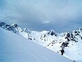
 Älplihorn with Älplisee |
||
| height | 2839 m above sea level M. | |
| location | Canton of Graubünden ( Switzerland ) | |
| Mountains | Plural pen | |
| Dominance | 0.61 km → Parpaner Rothorn | |
| Notch height | 63 m ↓ ridge between Älplihorn and Parpaner Rothorn | |
| Coordinates | 765 965 / 179 759 | |
|
||
| rock | crystalline (Silvretta blanket) | |
| First ascent | unknown | |
| Development | Mountain hiking trail (unmarked) | |

The Älplihorn is 2839 m one of the highest elevations of the plessur alps in the canton of Grisons in Switzerland . Due to its proximity to the Arosa Lenzerheide ski area , it is an easy-to-reach mountain in both summer and winter.
Location and surroundings
_Spherical_Panorama.jpg)
The Älplihorn is one of the central Plessurberge, a subgroup of the Plessuralpen. From the western summit of the Parpaner Rothorn a mountain range runs northwards towards the Prader Joch. From this ridge line, several side chains branch off one after the other to the northeast. A southernmost and only rudimentary side chain runs from the eastern summit of the Parpaner Rothorn directly to the Älplihorn. The summit can be climbed effortlessly and safely via this connecting ridge.
The Älplihorn is located in the area of the municipality of Arosa . In the west the mountain is bordered by the Totälpli, in the northwest by the Gredigs Älpli, in the northeast by the Schafälpli and in the east by the ore soils. The valley in the south is not named on the national map .
The neighboring peaks include the Parpaner Rothorn in the southwest, the Parpaner Weisshorn and the Tschirpen in the north, the Aroser Rothorn in the south and Erzhorn , Gamschtällihorn , Älpliseehorn and Schaftällihorn in the east.
The most distant visible point ( 48 ° 19 ′ 51.7 ″ N , 9 ° 11 ′ 11.9 ″ E ) from the Älplihorn is located at Castle Hölnstein , east of Stetten unter Holstein in Burladingen ( Baden-Württemberg ) and is 179 km away.
To the north of the Älplihorn is the Totseeli at 2393 m , to the east of it the Älplisee at 2155 m . The Plessur rises at the foot of the Älplihorn.
The valley location is Arosa. Frequent starting point of the Parpaner Rothorn.
Ore mining
As on the Aroser Rothorn , the Erzhorn and the Tschirpen , iron ore and other mineral resources were mined on the Älplihorn in the Middle Ages and smelted in the smelting furnaces in the Isel below Arosa.
Routes to the summit
Summer routes
From the Parpaner Rothorn
- Starting point: Parpaner Rothorn mountain station ( 2860 m )
- Via: Parpaner Rothorn Ostgipfel ( 2896 m ), connecting ridge
- Difficulty: EB
- Time required: ¾ hours
- Alternative: You can easily bypass the east summit on both sides.
Over the southwest ridge
- Starting point: Lenzerheide ( 1476 m ), Parpan ( 1493 m ), Scharmoin ( 1904 m ) or Innerarosa ( 1894 m )
- Via: Totälpli
- From Lenzerheide or Parpan wia Scharmoin and P. 2693 to Totälpli
- From Arosa via Älplisee, Gredigs Fürggli ( 2614 m ) and through the Rothornweg to Totälpli
- Difficulty level: EB (to Totälpli B and marked as a white-red-white hiking trail )
- Time required:
- 3¾ hours from Lenzerheide or Parpan, 2½ hours from Scharmoin
- 3¾ hours from Arosa, ¾ hours from Gredigs Fürggli
Over the east ridge
- Starting point: Innerarosa ( 1894 m )
- Via: Älplisee , valley to P. 2232
- Difficulty: BG (as far as Älplisee, marked as a white-red-white hiking trail )
- Time required: 3¾ hours (2¼ hours from Älplisee)
Through the southern flank
- Starting point: Innerarosa ( 1894 m )
- Via: Älplisee , into the valley to P. 2232, then southwards
- Difficulty: EB (up to Älplisee marked as a white-red-white hiking trail )
- Time required: 3¾ hours (2¼ hours from Älplisee)
Winter routes
From the Parpaner Rothorn
- Starting point: Parpaner Rothorn mountain station ( 2860 m )
- Via: North past the Parpaner Rothorn east summit ( 2896 m ) to P. 2776 on the connecting ridge
- Exposures: E
- Difficulty: L
- Time required: ¾ hours
Departure to Arosa
- End: Innerarosa ( 1829 m )
- Via: Älplisee
panorama
_Panorama.jpg)
gallery

View from Schafälpli to the summit

View from the summit to Älplisee with a young Plessur

Älplihorn and Plessurdelta at Älplisee
Älplihorn with Aroser Rothorn and Erzhorn (from right)


swell
- Manfred Hunziker: Ringelspitz / Arosa / Rätikon, Alpine Touren / Bündner Alpen , Verlag des SAC 2010, ISBN 978-3-85902-313-0 , p. 309.
- SAC Clubführer, Bündner Alpen 1, Tamina and Plessur Mountains , Verlag des SAC, 4th edition 1988, p. 31, 333 f.
- Hans Danuser , Ruedi Homberger: AROSA and the Schanfigg , self-published by Danuser / Homberger, Arosa 1988, p. 173 f.
Web links
- 360 ° panorama from the Älplihorn
- Tour reports on www.hikr.org
- Ramozhütte of the Swiss Alpine Club (SAC)
Individual evidence
- ↑ Calculated 360 ° panorama ( U. Deuschle ; information ) from the Älplihorn