Acas District
| Acas District | |
|---|---|
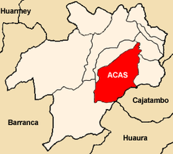
 Location of the district (marked in red) in the province of Ocros |
|
| Basic data | |
| Country | Peru |
| region | Ancash |
| province | Ocros |
| Seat | Acas |
| surface | 255 km² |
| Residents | 703 (2017) |
| density | 2.8 inhabitants per km² |
| founding | January 2, 1857 |
| ISO 3166-2 | PE-ANC |
| politics | |
| Alcalde District | Nectario Espinoza Ramírez (2019-2022) |
Coordinates: 10 ° 27 ′ S , 77 ° 20 ′ W
The Acas district is located in the Ocros province in the Ancash region of western Peru . The district was founded on January 2, 1857. It has an area of 255 km². The 2017 census counted 703 inhabitants. In 1993 the population was 451, in 2007 812. The district administration is located in the 3689 m high village of Acas with 362 inhabitants (as of 2017). Acas is just 10 km southeast of the provincial capital Ocros .
Geographical location
The Acas district is located in the Peruvian Western Cordillera in the central southeast of the Ocros province. The Río Pativilca flows west along the southeast and southern district boundaries. The Quebrada Caurajin and the lower reaches of the Río Ocros form the northern and western district boundaries.
The Acas district is bordered on the southwest by the district Cochas , in the northwest on the district Santiago de Chilcas , in the northeast to the districts of San Cristobal de Rajan and Carhuapampa and on the southeast by the districts Manas ( province Cajatambo ) and Ambar ( province Huaura ).
Web links
- Peru: Region Ancash (provinces and districts) at www.citypopulation.de