Accomarca district
| Accomarca district | |
|---|---|
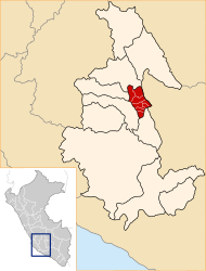
 The Accomarca district is the second southernmost in the Vilcas Huamán Province (marked in red) |
|
| Basic data | |
| Country | Peru |
| region | Ayacucho |
| province | Vilcas Huamán |
| Seat | Accomarca |
| surface | 86.5 km² |
| Residents | 936 (2017) |
| density | 11 inhabitants per km² |
| founding | January 29, 1965 |
| ISO 3166-2 | PE-AYA |
| politics | |
| Alcalde District | Fernando Ochoa Pomasoncco (2019-2022) |
| Political party | El Frente Amplio por Justicia, Vida y Libertad |
Coordinates: 13 ° 48 ′ 2 ″ S , 73 ° 54 ′ 15 ″ W.
The Accomarca district is located in the Vilcas Huamán Province in the Ayacucho region in south-central Peru . The district was established on January 29, 1965. It has an area of 86.5 km². The 2017 census counted 1430 inhabitants. In 1993 the population was 2083, in 2007 it was 2212. The district administration is located in the 3351 m high village of Accomarca with 440 inhabitants (as of 2017). Accomarca is 17 km south-southeast of the provincial capital Vilcas Huamán .
On August 14, 1985, 69 people were murdered by members of the army in the Accomarca massacre.
Geographical location
The Accomarca district is located in the Andean highlands in the south of the Vilcas Huamán province. The longitudinal extension in east-west direction is 14.5 km, the maximum width is about 7.5 km. The district is bounded by the Río Pampas to the east and west .
The district of Accomarca borders in the south with the district Independencia , in the west with the district Hualla ( province Víctor Fajardo ), in the north with the district Huambalpa and in the east with the districts Belén and Chalcos (both in the province Sucre ).
Localities
In addition to the main town, there are the following larger towns in the district:
- Arapacancha
- Huarcas (or San Gabriel de Huarcas)
- Pítec Portobelo
- Pongo Cocha
- Punturco
Web links
- Peru: Ayacucho region (provinces and districts) at www.citypopulation.de
- INEI Perú