Hualla District
| Hualla District | |||
|---|---|---|---|
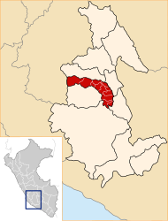
 The district of Hualla is located in the north-east of the province of Víctor Fajardo (marked in red) |
|||
| Symbols | |||
|
|||
| Basic data | |||
| Country | Peru | ||
| region | Ayacucho | ||
| province | Víctor Fajardo | ||
| Seat | San Pedro de Hualla | ||
| surface | 157 km² | ||
| Residents | 2189 (2017) | ||
| density | 14 inhabitants per km² | ||
| founding | April 16, 1828 | ||
| ISO 3166-2 | PE-AYA | ||
| politics | |||
| Alcalde District | Edgar Ipurre Uscata (2019-2022) |
||
| Political party | Musuq ñan | ||
| Plaza de Armas in San Pedro de Hualla (2018) | |||
Coordinates: 13 ° 51 ′ S , 73 ° 57 ′ W
The Hualla District , alternative spelling: Huaya District , is located in the Víctor Fajardo Province in the Ayacucho region in south-central Peru . The district was founded on April 16, 1828. It has an area of 157 km². The 2017 census counted 2189 inhabitants. In 1993 the population was 2732, in 2007 it was 3188. The seat of the district administration is the 3341 m high village of San Pedro de Hualla (or Hualla for short) with 1420 inhabitants (as of 2017). San Pedro de Hualla is located about 16 km southeast of the provincial capital Huancapi .
Geographical location
The Hualla district is located in the Andean highlands in the north-east of the Víctor Fajardo province. The Río Pampas flows along the eastern district boundary towards the south-southeast.
The district of Hualla borders in the south on the district Canaria , in the northwest on the district Huancapi , in the north on the district Cayara and in the east on the districts Accomarca and Independencia (both in the province Vilcas Huamán ).
Localities
In addition to the main town, there are the following larger towns in the district:
- Tiquihua (533 inhabitants)
Web links
- Peru: Ayacucho region (provinces and districts) at www.citypopulation.de
- INEI Perú


