Vilcanchos district
| Vilcanchos district | |
|---|---|
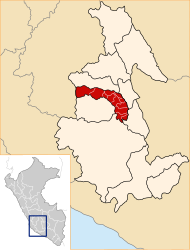
 The district of Vilcanchos is located in the far west of the province of Víctor Fajardo (marked in red) |
|
| Basic data | |
| Country | Peru |
| region | Ayacucho |
| province | Víctor Fajardo |
| Seat | Vilcanchos |
| surface | 500 km² |
| Residents | 2497 (2017) |
| density | 5 inhabitants per km² |
| founding | November 14, 1910 |
| ISO 3166-2 | PE-AYA |
| politics | |
| Alcalde District | Elmer Godoy Vila (2019-2022) |
| Political party | Qatun Tarpuy |
Coordinates: 13 ° 37 ′ S , 74 ° 32 ′ W
The district of Vilcanchos is located in the province of Víctor Fajardo in the Ayacucho region in south-central Peru . The district was founded on November 14, 1910. It has an area of about 500 km². The 2017 census counted 2,497 inhabitants. In 1993 the population was 2950, in 2007 it was 2906. The district administration is located in the 2982 m high village of Vilcanchos with 415 inhabitants (as of 2017). Vilcanchos is just 53 km west-northwest of the provincial capital Huancapi .
Geographical location
The Vilcanchos district is located in the Andean highlands in the far west of the Víctor Fajardo province. The district is bounded in the north by the Río Pampas flowing to the east . This drains the area.
The Vilcanchos district is bordered by the Pilpichaca district ( Huaytará province ) to the west, the Paras and Totos districts (both in the Cangallo province ) to the north, the Sarhua district to the east, and the Santiago de Lucanamarca district ( Huanca Sancos province ) to the south ).
Localities
In addition to the main town, there are the following larger towns in the district:
- Antacocha (258 inhabitants)
- Cocas (390 inhabitants)
- Espite
- San Jacinto (262 inhabitants)
Web links
- Peru: Ayacucho region (provinces and districts) at www.citypopulation.de
- INEI Perú