Acworth (Georgia)
| Acworth | |
|---|---|
| Nickname : The Lake City | |
 Downtown Acworth |
|
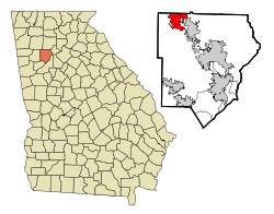
| Location in Georgia | |
| Basic data | |
| Foundation : | 1840 |
| State : | United States |
| State : | Georgia |
| County : | Cobb County |
| Coordinates : | 34 ° 4 ′ N , 84 ° 40 ′ W |
| Time zone : | Eastern ( UTC − 5 / −4 ) |
| Residents : | 20,425 (as of 2010) |
| Population density : | 1,116.1 inhabitants per km 2 |
| Area : | 19.7 km 2 (approx. 8 mi 2 ) of which 18.3 km 2 (approx. 7 mi 2 ) is land |
| Height : | 277 m |
| Postcodes : | 30101, 30102 |
| Area code : | +1 770, 678 |
| FIPS : | 13-00408 |
| GNIS ID : | 354258 |
| Website : | www.acworth.org |
| Mayor : | Tommy Allegood |
Acworth is a city in Cobb County in the US state of Georgia with 20,425 inhabitants (as of 2010).
geography
Acworth is bordered by Cartersville ( Bartow County ) to the northwest and Kennesaw to the southeast . The city is about 15 km northwest of Marietta and about 40 km northwest of Atlanta . Near the town popularly known as "The Lake City" are the man-made lakes, Lake Allatoona and Lake Acworth , created in the late 1940s .
history
From 1845, the Western and Atlantic Railroad began building a railway line from Atlanta northwards towards Chattanooga . Over the years, a settlement developed on the route, which finally ended on December 1, 1860 in the establishment of the City of Acworth.
During the Civil War , the city was burned down by General William T. Sherman in November 1864 , only a few houses escaped the flames. Parts of the feature film Footloose were shot here.
Demographic data
According to the 2010 census, the then 20,425 inhabitants were distributed among 7,656 inhabited households, which results in an average of 2.67 people per household. There are a total of 8,360 households.
68.4% of the households were family households (consisting of married couples with or without offspring or one parent with offspring) with an average size of 3.21 persons. There were children under the age of 18 in 40.8% of all households and persons aged 65 and over in 16.8% of all households.
30.6% of the population were younger than 20 years, 31.1% were 20 to 39 years old, 26.2% were 40 to 59 years old, and 11.9% were at least 60 years old. The mean age was 33 years. 47.6% of the population were male and 52.4% were female.
62.5% of the population identified themselves as whites , 25.6% as African-Americans , 0.3% as Indians and 3.5% as Asian Americans . 5.1% said they belonged to another ethnic group and 3.1% to several ethnic groups. 12.4% of the population was made up of Hispanics or Latinos .
The average annual income per household was 55,226 USD , while 10.7% of the population lived below the poverty line.
Attractions
The following properties are listed on the National Register of Historic Places :
- Acworth Downtown Historic District
- Bethel AME Church
- Collins Avenue Historic District
- Cowen, Stephen D., House
- Lake Acworth Beach and Bathhouse
- Moore, Tarleton, House
traffic
Acworth is affected by Interstate 75 and crossed by US Highway 41 and Georgia State Route 92 . Passenger traffic on the Atlanta – Chattanooga line was discontinued on April 30, 1970. Today the route is used by CSX for freight traffic. The nearest airport is Atlanta Airport (around 60 km south).
crime
The crime rate in 2010 was 112 points (US average: 266 points) in the low range. There were five robberies, nine assaults, 35 break-ins, 366 thefts and 25 car thefts.
Web links
- Website of the city (Engl.)
Individual evidence
- ^ History. Retrieved February 27, 2018 .
- ^ Profile of General Population and Housing Characteristics: 2010 . United States Census Bureau . Retrieved February 27, 2018.
- ↑ GEORGIA - Cobb County. National Register of Historic Places , accessed February 27, 2018 .
- ↑ http://www.city-data.com/crime/crime-Acworth-Georgia.html

