Altenseelbach
|
Altenseelbach
Neunkirchen municipality
Coordinates: 50 ° 46 ′ 44 ″ N , 7 ° 59 ′ 42 ″ E
|
|
|---|---|
| Height : | 289 (280-300) m |
| Area : | 6.16 km² |
| Residents : | 1380 (December 31, 2014) |
| Population density : | 224 inhabitants / km² |
| Incorporation : | 1st January 1969 |
| Postal code : | 57290 |
| Area code : | 02735 |
|
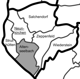
Location of Altenseelbach within the municipality of Neunkirchen.
|
|
Altenseelbach is a district of the municipality of Neunkirchen in the Siegen-Wittgenstein district in North Rhine-Westphalia with 1,380 inhabitants (as of December 31, 2014).
geography
location
Altenseelbach is the second smallest part of Neunkirchen and is located in the southern Siegerland near the border with Rhineland-Palatinate . Through the streams flow Daadenbach in the West and in the village the Lützelbach receiving Seelbach in the east; both flow into the Heller . The highest elevation near the to about 280 to 300 m above sea level. NHN located village is the Hohenseelbachskopf (Köppel) with 517.5 m ; northeast of the village is the Hellerberg ( 366.9 m ).
Neighboring places
Neunkirchen in the north and northeast, Zeppenfeld and Wiederstein in the east, Wahlbach in the southeast, Emmerzhausen in the south, Daaden and Biersdorf in the southwest and Herdorf and Struthütten in the west are neighboring towns of Altenseelbach .
history
In 1270 a knight family von Seelbach was mentioned, on August 23, 1288 the noble family von Seelbach and the place were first mentioned in a document. In 1350 it built a large ring-shaped castle on the basalt knoll of the Hohenseelbachskopf, which was destroyed again by the Archbishop of Trier in 1352. On March 4, 1739, with the death of Johann Konrad Wilhelm von Seelbach-Reuss in Zeppenfeld, the lineage of the Lords of Seelbach went out.
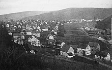
The first fire in the village probably took place before 1750. There is no more information on this. In the summer of 1757 it burned for the second time in Altenseelbach. On September 29, 1783, a lightning bolt triggered another major fire, in which 57 houses and 49 barns burned down. Four houses were spared because they were on the eastern edge of the village. As early as 1788 there were 61 houses in the village again. Due to the rebuilding of Altenseelbach and the resulting parallel streets, the nickname "Reihendorf" was created.
A school was built in 1905 after the first building was demolished in 1878. On July 25, 1920, the war memorial was inaugurated in the village. In 1931 the Altenseelbach community lived from ore mining. Of the 1230 inhabitants, 1,055 were Protestant, 19 Catholic and 156 of other denominations. Facilities were, for example, a primary school and a sports field.
Until the municipal reorganization on January 1, 1969, the place belonged to the office of Burbach .
Mining
In the Altenseelbach area there were three large pits (marked in bold) and a few other small ones:
- Alte Burg was in operation from 1880.
- Opportunity was closed in the late 1870s. A machine shaft went down to a depth of 60 m . A total of 5,187 t of iron stone, 54 t of copper ore and 3 t of lead ore were mined.
- Gleiskaute from 1736, later called Wilhelmsgruss .
- Great Castle Pit : TheGreat Castlemergerwas created from several small pits on August 29, 1838. The mine had its heyday in the 1940s. Theman soap shafthad a depth of 419 m, the total depth of the pit was 895 m. 576,483 t of iron ore were extracted from the mine. In 1959 it was shut down.
- Gustavszeche
- Good hope , there was a tunnel with a length of 1008 m and a machine shaft. Around 1920 there was a consolidation with Lohmannsfeld, Silberart and Alte Burg to form the Great Castle pit. There was a wet mechanical treatment on the mine dump. Lead sheen and zinc blende were dismantled .
- Lohmannsfeld : In theLohmannsfeldarea, 223,486 tons of ore were mined from the 18th century to 1948 at a depth of up to 780 m.
- Silberart was active from the mid-1850s through 1880. There was a deep tunnel in the Seelbachtal, which was created in the 1850s and was 380 m long. Around 1920 the consolidation withLohmannsfeld,Gute HopeandAlte Burgto the GrubeGroße Burgtook place. Zinc blende, galena andcopper pebbleswere mined using silver.
- Veteran . The veteran tunnel was built in 1877, closed in the 1880s and was 82 m long. Eisenstein and galena were mined. In 1954, the Erzbergbau Siegerland AG carried out investigations on the Carlshoffnung gear medium .
Population numbers
Population of the place:
|
|
|
Note: Population figures from 1994 on December 31; 2000 in October
House numbers
| year | 1600 | 1698 | 1700 | 1704 | 1706 | 1725 | 1730 | 1739 | 1788 | 1810 | 1846 | 1850 | 1867 | 1913 |
|---|---|---|---|---|---|---|---|---|---|---|---|---|---|---|
| Houses | 27 | 33 | 39 | 39 | 40 | 49 | 49 | 61 | 61 | 61 | 67 | 74 | 90 | 184 |
Infrastructure and transport links
traffic
Altenseelbach has a stop on the Betzdorf – Haiger railway line . Altenseelbach is connected to the A 45 via Neunkirchen, Salchendorf and Wilden . There is a traffic training area in the village.
Business
The Daadenbach industrial park is located near the Daadenbach . This was in the interest of the local media in 2008 and 2009, as an old stone crusher plant in the immediate vicinity of a residential area is to be fully used again.
Attractions
The Hohenseelbachskopf is one of the large basalt domes that were created here around 7 million years ago through volcanic activity. Basalt mining for road construction led to the removal of the dome between 1900 and 1925, but not as much as in neighboring Mahlscheid . The area on the Hohenseelbachskopf has been a nature reserve since 1990. Today there is a restaurant on the mountain. the Köppel is a popular destination. In 1350, the noble family von Seelbach built a large ring-shaped castle fortress on the basalt knoll, which was destroyed two years later by the Archbishop of Trier because their owners were alleged robber barons .
School and free time
The place had a primary school , which was closed after the end of the 2007/08 school year due to a lack of students . After that, some of the rooms were used by the IG Modellbahn Dielfen association and TV Neunkirchen . In 2015, the building was converted into refugee accommodation and has since been home to several asylum seekers.
The former school building ("old school", until the end of the 1930s) and today's village community center in Breitelbachstrasse has a kitchen and, until 2010, a 150 m² hall with a stage. Up to 150 people found seats here. From 2010 to 2013, the large hall of the village community center was converted into a training and community room for the local fire brigade train with funds from economic stimulus package 2 , the Neunkirchen community and the Altenseelbach fire-fighting train association. In the course of this renovation, part of the hall was separated and the resulting room was equipped with a kitchenette. The large hall now offers seats for up to 100 people on an area of approx. 130 m² as well as multimedia equipment with projector, screen and audio system for training courses and courses. The Altenseelbach fire fighting train carried out a large part of the work on its own.
While the small hall on the upper floor is still used by the Heimatverein, the rooms of the former caretaker's apartment were made available to the "Photo Friends Neunkirchen" association.
societies
The local homeland association has existed since 1933 and has around 300 active members. He takes care of monuments and village care, and cultural evenings , excursions and Backes festivals. There are also several other associations and institutions.
One of the clubs is the SV 2010 Altenseelbach eV This club was founded in 2010 with the aim of bringing a little past football tradition of SV 1910 Altenseelbach back to the district. The venue is a tennis court on Waldstrasse.
literature
- 700 years of Neunkirchen , Otto Braun Verlag, Neunkirchen 1988.
Individual evidence
- ↑ Siegener Urkundenbuch Volume I, Siegen , 1887, pp. 34–35, no. 55.
- ^ A b 700 years Neunkirchen , Otto Braun Verlag, Neunkirchen 1988; P. 159/160
- ↑ Article The Worst Day in Village History in the Siegener Zeitung of July 29, 2008, page 8
- ↑ Otto Braun: Neunkirchen in old pictures , Neunkirchen 1980
- ↑ a b genealogy.net: Office Burbach
- ↑ Martin Bünermann: The communities of the first reorganization program in North Rhine-Westphalia . Deutscher Gemeindeverlag, Cologne 1970, p. 72 .
- ↑ 700 years of Neunkirchen , Otto Braun Verlag, Neunkirchen 1988
- ^ Otto Schaefer: The district of Siegen , Siegen 1968
- ↑ a b c d e f g h i j k E. Weidenbach: History of the county of Sayn and the components of the same , print E. Weidenbach, Dillenburg 1874, p. 287.
- ↑ Westfälisches Gemeindelexikon 1887, pp. 108/109
- ↑ Westfälisches Gemeindelexikon 1897, pp. 110/111
- ↑ gemeindeververzeichnis.de: District of Siegen
- ↑ a b Heinrich Gamann: history of free reason , printing of the West German Publishing Company, Neunkirchen 1925, p. 6
- ↑ a b Michael Rademacher: German administrative history from the unification of the empire in 1871 to the reunification in 1990. City and district of Siegen. (Online material for the dissertation, Osnabrück 2006).
- ↑ Martin Bünermann, Heinz Köstering: The communities and districts after the municipal territorial reform in North Rhine-Westphalia . Deutscher Gemeindeverlag, Cologne 1975, ISBN 3-555-30092-X , p. 157 .
- ^ Rolf Betz: Neunkirchen. (PDF) Retrieved July 4, 2019 . (PDF; 7.3 MB) , approx. 1995
- ^ Community information Neunkirchen ( Memento from March 6, 2001 in the Internet Archive )
- ^ Community Neunkirchen in Siegerland: Citizens' Information Figures / Data / Facts ( Memento from April 2, 2015 in the Internet Archive )
- ↑ neunkirchen-siegerland.de: population data ( Memento of 31 August 2007 at the Internet Archive )
- ↑ a b neunkirchen-siegerland.de: facts and figures


