
Arnspitz group
| Arnspitz group | ||
|---|---|---|
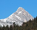
 The Große Arnspitze is the main summit of the Arnspitz group |
||
| Highest peak | Great Arnspitze ( 2196 m above sea level ) | |
| location | Innsbruck-Land district , Tyrol ; Garmisch-Partenkirchen district , Bavaria | |
| part of | Wetterstein Mountains ; North Tyrolean Limestone Alps | |
|
||
| Coordinates | 47 ° 23 '50 " N , 11 ° 13' 21" E | |
| particularities | Nature reserve | |
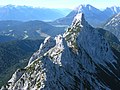
 Arnspitz group from the south |
||

The Arnspitz group is a subgroup of the Wetterstein Mountains and lies between Seefeld in Tyrol and Mittenwald in Bavaria or between the Leutasch Valley in the west and the Isar Valley near Scharnitz in the east. The greater part belongs to Tyrol, its northeast part to Bavaria. The border between Bavaria and Tyrol leads over the summit of the Großer Arnspitze .
summit
- Schartenkopf ( 1616 m above sea level )
- Great Arnspitze ( 2196 m above sea level )
- Mittlere Arnspitze ( 2091 m above sea level )
- Arnplattenspitze (Hintere Arnspitze) ( 2171 m above sea level )
- Weißlehnkopf ( 2002 m above sea level )
- Arnkopf ( 1934 m above sea level )
- Zwirchkopf ( 1773 m above sea level )
(along the main chain, from the northeast)
A spur to the east forms from the Großer Arnspitze, the summit of which is Arntalköpfle ( 1529 m above sea level ) on the west side of the valley narrowing of the Scharnitz pass .
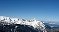
View from the Großer Arnspitze over the double-peaked Mittlere Arnspitze to the Arnplattenspitze

The Arnplattenspitze (left) and Mittlere Arnspitze (right) from the Wildsee
Arnplattenspitze from the south
Arnspitze group of southeast with Arntalköpfle bottom right, left behind Wettersteinspitzen and wall

Arnspitz Group and Northern Karwendel Range from the south

Summit of the Arnspitz group from the east: Arnplattenspitze, Mittlere Arnspitze, Große Arnspitze

Arnspitze group of Seefeld seen from


Streets and paths
There is no public road into the area, just a very steep forest road from the Leutasch district of Ahrn to the Hohe Sattel . From the hamlet of Ahrn and from the Hoher Sattel hunting lodge, trails lead to the individual peaks. While the Große Arnspitze and the Arnplattenspitze can be reached either from Mittenwald via the Riedberg or from Scharnitz as a partially exposed mountain tour, crossing the ridge of the three peaks requires climbing skills of the third degree (if bypassing the Mittleren Arnspitze the second degree). The most scenic ascent to the Große Arnspitze leads from the Leutasch over the Riedbergscharte and the Achterköpfe . Below the summit is the unmanaged Arnspitzhütte at 1930 m .
geology
The arnspitze group is part of the Northern Limestone Alps , is tectonically largely to Inntal ceiling , only the northernmost part from the Riedenberg Charter is one of the Lechtal on. The Arnspitz group is mainly built up from rocks of the Wetterstein Limestone, which falls to the southeast . In the area of the Hohe Sattels a band of Raibler strata moves from west to east, while the Zunteregg , which lies in front of the Arnspitzen to the south, 1682 m above sea level. A. is made up of rocks from the main dolomite . Lead used to be mined at the foot of the Großer Arnspitze. The mine was located on Bavarian territory just north of the Austrian border in the Isar Valley, at the southwestern end of the Riedboden.
Arnspitze nature reserve
The Arnspitz group is a nature reserve . The Arnspitze nature reserve was established on November 19, 1942. Today's Austrian part, in the area of the municipalities of Leutasch and Scharnitz , Innsbruck-Land district, is a nature reserve after Tir. Nature Conservation Act , covers 10.8 km² and is the oldest nature reserve in the state of Tyrol . The Bavarian part covers 1.7 km².
Others
At the end of August 1947, a devastating fire broke out on the southeast side of the Arnspitze due to the extreme drought, in which thousands of firefighters from Upper Bavaria and Tyrol worked for weeks. The mountain flank has been bare since that time.
The first documented ski run of the Arnplattenspitze took place on January 2nd, 2018 by David Sikan.
literature
- W. Oberhuber: Nature reserve Arnspitze nature inventory. On behalf of the Environmental Protection Department, Office of the Tyrolean Provincial Government. 1995
Web links
Individual evidence
- ^ Geological map of the Republic of Austria 1: 50,000 , sheet 117 Zirl, Geologische Bundesanstalt Wien 1992.
- ↑ Karwendel Mountains Alpine Club Map , Western Journal , No. 5/1
- ↑ tiris gives 11,659.22 ha
- ↑ Arnspitze. In: tiroler-schutzgebiete.at. Office of the Tyrolean Provincial Government, Department of Environmental Protection, archived from the original on May 30, 2016 ; accessed on May 30, 2016 .
- ↑ Alpenpark Karwendel Magazin 2006/06, p. 13 f ( Memento from May 17, 2008 in the Internet Archive )
- ↑ 7SummitCrew (@ 7summitcrew) • Instagram photos and videos. Retrieved February 3, 2018 .

Altenauer Moor | Ammer Mountains | Ammerschlucht at the Echelsbacher Bridge | Ammer Gorge in the Scheibum area | Arnspitze | Humpback meadows on the goat skull | Humpback meadows on the Plattele | Ettaler Weidmoos | Froschhauser See | Karwendel and Karwendel foothills | Kochelfilz near Unterammergau | Murnauer Moos | Powder moss | Riedboden | Schachen and Reintal | Western Staffelsee with adjacent moors