
Meadow (hunte)
|
Aue also called Visbeker Aue - a section southeast of Ahlhorn is as Engelmannsbäke and Small Bäke known |
||
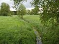
_-_01.JPG) The floodplain |
||
| Data | ||
| location | District of Vechta , District of Cloppenburg and District of Oldenburg , Lower Saxony | |
| River system | Weser | |
| Drain over | Hunte → Weser → North Sea | |
| source | northwest of Halter , Visbek municipality 52 ° 50 ′ 11 ″ N , 8 ° 14 ′ 35 ″ E |
|
| Source height | 49 m | |
| muzzle | south of Dötlingen in the Hunte coordinates: 52 ° 55 ′ 29 " N , 8 ° 22 ′ 49" E 52 ° 55 ′ 29 " N , 8 ° 22 ′ 49" E |
|
| Mouth height | 16 m | |
| Height difference | 33 m | |
| Bottom slope | about 1.5 ‰ | |
| length | about 22.1 km | |
| Catchment area | 95 km² | |
| Left tributaries | Landwehrbäke | |
| Right tributaries | Meyerhöfener Wasserzug , Twillbäke , Varnhorn Wasserzug, Holzhauser Bäke | |
| Communities | Visbek , Emstek , Großenkneten , Wildeshausen and Dötlingen | |
The Aue ( ) - a sand-shaped lowland stream - is an approximately 22-kilometer-long left tributary of the Hunte in the Lower Saxony districts of Vechta and Oldenburg . The Aue touches the district of Cloppenburg as the border river to the district of Vechta. A second river called Aue also forms the border between the districts of Cloppenburg and Vechta, between the municipality of Essen / Oldenburg and the city of Dinklage .
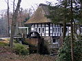
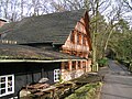
The floodplain has - directly on the Weser-Ems watershed - two source streams northwest of Halter , a farming community in the Visbek community . After taking up the Meyerhöfen watercourse , it flows over the mill ponds of the Endel watermills Stüvenmühle , Neumühle and Kokenmühle in a northerly direction parallel to Kreisstraße 235 and then crosses under Landesstraße 880. Below the Kokenmühle, the floodplain changes its course to the east and takes the Landwehrbäke from the left and im further on from the right the Twillbäke and the Varnhorn watercourse . The confluence of the Landwehrbäke with the Aue marks the border point between the three districts of Oldenburg in the north, Vechta in the southeast and Cloppenburg in the southwest. The floodplain then passes under the federal highway 213 and then the federal highway 1 . Between these two highways in Aumühle it takes the Holzhauser Bäke from the right coming from the south . From the headwaters to the crossing under the B 213, the floodplain flows through the “ Bäken der Endeler und Holzhauser Heide ” nature reserve . Finally it flows between the nature reserve “ Glaner Heide ” and the area of the golf club “Wildeshauser Geest e. V. “and flows into the Hunte south of Dötlingen .
A section of the floodplain in the area southeast of Ahlhorn , which here represents the border between the districts of Vechta and Oldenburg, is also known as "Engelmannsbäke" and - to the east of it - as "Kleine Bäke". In the immediate vicinity are the megalithic large stone graves of the Visbeker groom and the heathen sacrificial table from the Neolithic funnel cup culture . From the level of Gut Stüvenmühle there are numerous other Neolithic large stone graves to the left and right of the floodplain.
The Meyerhöfener Wasserzug

The Stüvenmühle in Endel
The Neumühle in Endel
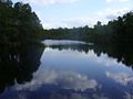
Mill pond at the Neumühle
The coke mill in Endel

Sawmill of Kokenmühle
Bridge at the weir of the Kokenmühle

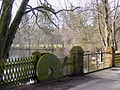
Mill pond at the coke mill

The heathen sacrificial table at Engelmannsbäke

Floodplain I

Floodplain II

Auebrücke between Thölstedt and Steinloge
_-_01.JPG)


_-_01.JPG)


_-_01.JPG)


Web links
- Nature reserve "Bäken der Endeler und Holzhauser Heide" at the Lower Saxony State Office for Water Management, Coastal Protection and Nature Conservation
- Navigator focused on the floodplain, interactive. Official map service of the LGLN
Individual evidence
- ↑ NLWKN state database. WK25055 Aue + tributaries . Retrieved September 1, 2015.
- ↑ Lower Saxony Mühlenstrasse: Neumühle Visbek
- ↑ Lower Saxony Mill Road: Kokenmühle Visbek