
Barmsteine
| Barmsteine | ||
|---|---|---|
 Großer (left) and Kleiner Barmstein (840 m, right) from Bad Dürrnberg . |
||
| height | 851 m above sea level A. | |
| location | Bavaria , Germany and Salzburg , Austria | |
| Mountains | Berchtesgaden Alps | |
| Dominance | 0.8 km → Hoher Götschen | |
| Notch height | 71 m ↓ Luegbichl | |
| Coordinates | 47 ° 41 '23 " N , 13 ° 4' 35" E | |
|
||
| rock | Barmstein lime | |

The Barmsteine ( Bavarian : Bamstoana ) are two rock towers with a height of 841 m and 851 m on the northeastern edge of the Berchtesgaden Alps , and on the west side of the Salzach Valley . They stand above the Austrian city of Hallein , on the steeply sloping flank of the Tuval, and over them the border between the district of Berchtesgadener Land and the state of Salzburg and between Germany and Austria runs.


geology
In geology , they are known as the namesake of the so-called Barmstein Limestone , a part of the Oberalm Formation of the higher Jura that is interpreted as turbidite .
Geotope
Großer and Kleiner Barmstein have been designated by the Bavarian State Office for the Environment as particularly valuable geotopes (geotope number: 172R036).

The great Barmstein, on the right the Salzburger, on the left the Berchtesgadener Land
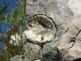
A rock deposit on the small Barmstein


history

In the Middle Ages, these two rock formations were called “Pürkstein” and “Pöberstein”, the gap between them was called “Marchscharte”. In the treatise by Franz Valentin Zillner (1816–1896) about the salt system in Salzburg, the “Pabensteinen” are repeatedly written as striking rock spikes on the steeply sloping areas of the Tuval .
So-called wind tunnels (wind holes) run through the Barmsteine to the Hallein district of Kaltenhausen , which were used from the 15th century to cool the beer from the nearby Hofbräu Kaltenhausen brewery . The alpine club path on the small Barmstein was laid out in 1885 and renewed in 1926 by the Hallein ÖAV section (with steps and wire ropes).
Even during the time of National Socialism, the Barmsteine were used in a visible and invisible way: in addition to the use of tunnels as a location for the armaments industry, a large swastika was affixed in white before Austria was annexed to Germany so that it was clearly visible in the direction of Austria. It was removed after the war and is hardly recognizable today.
A maypole has been erected on the Kleiner Barmstein since 1815. Transporting it by hand is difficult due to the exposed location, so the tree is not replaced every year, but only when it breaks or is getting old. The tradition demands that the freshly decorated tree stands at the 12 o'clock ring of the parish and pilgrimage church Dürrnberg . As a reward, those involved receive the so-called Moabambier ( "maypole beer" ), a barrel of beer from the Hofbräu Kaltenhausen . This right has been documented since 1841.
legend
The people of Hallein call the Barmsteine the “Halleiner Ohrwaschln” as a symbol of the city. According to legend, the Marchscharte was bitten out between the rocks by the devil when he looked over from Bavaria and saw a church procession in Kaltenhausen.
Climbing and hiking
The rock towers are a popular destination, especially with climbers , as they are lit by the sun until late in the evening and are easy to reach. The difficulty level of the small Barmstein is II to III-, the large Barmstein, on the other hand, is much more demanding in terms of climbing. In addition to the two large barmstones, there are also the Katzenbarmsteine , which extend along the south ridge of the small barmstein. There is also a bouldering park there .

The Barmsteine can also be easily climbed via paths with steps carved into the rock with handrails and some places with wire rope insurance. This approach is on the south side of the Kleiner Barmstein. Nevertheless, you should be free from giddiness and sure-footed for these climbs. The Thürndl ruins , which are only a little to the east, are also worth seeing for hikers .
In front of the Barmsteinen there are the forest and meadow slopes of the Gnotschaft Mehlweg , over which you can hike via the Köppelschneid to Schellenberg.
In January 2008, the property owner closed the south side of the Kleiner Barmstein to climbers with the help of a fence after several violations of the climbing rules.

The climbing ordinance on the Barmstein

Fence to lock the Kleiner Barmstein for climbers


literature
- Karl Zinnburg, Franz Kurz: Bad Dürrnberg . Spa administration, Bad Dürrnberg 1980, OBV .
- Benno Plöchinger: For evidence of Jurassic-Cretan discharges of Hallstatt rock masses on both sides of the Salzach-Quertal (Salzburg) . In: Geologische Vereinigung (Ed.): Geologische Rundschau . Volume 73.1984. Springer, Berlin / Heidelberg, pp. 293-304, DNB , OBV .
- Gero Moosleitner: Collecting fossils in the Salzburg region. A guide to classic and new sources . 1st edition. Edition Goldschneck, Wiebelsheim 2004, ISBN 3-494-01374-8 (therein p. 29 and 149 on the two stones and the Barmstein limes).
Remarks
- ^ Bavarian State Office for the Environment, Geotop Großer and Kleiner Barmstein (accessed on October 19, 2017).
- ^ Franz Valentin Zillner : On the history of the Salzburg salt system . Salzburg 1879, p. 24 f. ( Digitized version )
- ↑ Stefan Herbke: Mountain tour on the Barmsteine. Pair of rocks over Hallein . In: sueddeutsche.de , May 29, 2012, accessed on August 16, 2013.
- ^ Section Hallein . In: Hanns Barth (Red.): Communications from the German and Austrian Alpine Club . No. 14/1926, Volume LII, Munich 1926, p. 163, top right. (Online at ALO ).
- ↑ Hallein's spectacular Barmsteine , broadcast on November 17, 2016 in the series “119 Places, 119 Treasures” by Radio Salzburg , on the swastika on the Barmstein with illus. See section Nazis use borders for propaganda , online at salzburg.orf.at
- ↑ The maypole, traditionally set up on the Bavarian side, is pulled up on the rock face. - In: Zinnburg: Bad Dürrnberg , p. 40.
- ↑ Die Barmsteine - Großer and Kleiner Barmstein , with the section The Maypole on the Kleiner Barmstein , online at berchtesgaden.de
- ↑ Maypole at lofty heights on the Barmstein , broadcast on May 1, 2018 on Radio Salzburg, online at salzburg.orf.at
- ↑ How the Barmsteine got their shape , Sage about the Barmsteine, named source: Josef Brettenthaler: Das Großes Salzburger Sagenbuch . Krispl 1994, p. 111; online at haben.at
- ↑ Stefan Herbke: The most beautiful panorama tours between Berchtesgaden and Oberstdorf. Path length, difficulty, refreshment stops, detailed maps and overview map . J. Berg, Munich 2005, ISBN 3-7658-4097-1 , p. 8.
- ↑ Website alpintouren.com about mountain hikes on the Barmsteine
- ↑ Hellmut Schöner : Berchtesgaden Alps. Area guide for hikers and mountaineers . 7th edition. Rother, Munich 1995, p. 76. ( Online ).
- ↑ Gerald Lehner : Barmstein is blocked because of hooligans . In: salzburg.orf.at , January 27, 2008, accessed on December 12, 2010.