
Göttelborn mine
| Göttelborn mine | |||
|---|---|---|---|
| General information about the mine | |||
 |
|||
| Mining technology | Longwall mining | ||
| Information about the mining company | |||
| Operating company | Ruhrkohle AG | ||
| Start of operation | 1446 | ||
| End of operation | 2000 | ||
| Successor use | Industrial park, solar power plant | ||
| Funded raw materials | |||
| Degradation of | Hard coal | ||
| Geographical location | |||
| Coordinates | 49 ° 20 '37 " N , 7 ° 2' 18" E | ||
|
|||
| Location | Gottelborn | ||
| local community | Quiver | ||
| Regional Association ( NUTS3 ) | Saarbrücken | ||
| country | State of Saarland | ||
| Country | Germany | ||
| District | Saar district | ||

The Göttelborn mine was one of the most important Saarland hard coal mines operated by Saarbergwerke AG , later by Ruhrkohle AG (RAG) . It is located in the district of Göttelborn in the municipality of Quiigart , around 12 kilometers north of Saarbrücken .
history
The coal extraction in the Göttelborn field about 400 years ago is documented in the "Quierschieder Jahrgeding" from 1446. There the term "Kollwald" refers to coal graves in the Kohlbachtal. 18 coal graves are mentioned in 1730, some of which were employed in the Fischbachtal (presumably in the Quiigart area).
The mine
With the closure of the plant in 2000, the hopes of many miners, but also some of the credibility of politics were lost. In the end, until the end it was said: "The coal on the Saar is safe."
Today the Göttelborn mine is a symbol of the failed coal policy, as the new, promising new times Shaft IV was only used for six years.
In 1988 Saarbergwerke AG decided on its three-pit concept, which envisaged the economic and logistical merging of the three previously independent mines Ensdorf, Reden / Göttelborn and Warndt / Luisenthal. This included a high-performance conveyor system at the central location in Göttelborn. This was to ensure more efficient coal extraction. The coal yields were to be used to supply the Saarland and some other southwest German coal-fired power plants. The maximum conveying capacity was designed for 1,050 tons of raw coal per hour or 2.5 million tons per year .
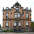
Mountain preschool , built in 1887
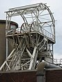
Headframe shaft 3

Headframe shaft 2


Existing facilities of the mine
Shaft 2
The shaft 2 was in 1920 sunk . The 5.10 m diameter shaft has a 23.62 m high solid wall headframe designed for a rope breaking load of 3,500 kN and a rope pulley diameter of 6,000 mm.
Shaft 3
The headframe of shaft 3 was erected between 1925 and 1926, it is a German strut frame from the B. Seibert company. Due to the technical and architectural quality, this headframe was placed under monument protection. The headframe of the shaft has a height of 13.45 m. The shaft has a diameter of 6.00 m. The winding tower was built for a rope breaking load of 2,250 kN, it has a pulley diameter of 5,500 mm and is smaller than the winding tower of shaft 2.
Shaft 4
In January 1990, work began on the 90 m high headframe. The conveyor system installed in the 1160 meter deep shaft ( depth in December 1992) with a diameter of nine meters (8.3 meters of which can be used) could carry up to 34 tons of payload at a speed of 65 km / h or up to 93 miners at 43 km / h. h move , their output was 7.5 megawatts (approx. 10,000 hp).
When it was built, the headframe was considered the highest headframe in the world. The rope sheaves with a diameter of 7.5 meters were mounted at a height of 74 meters and provided with 6.8 cm thick steel cables . The investments in the construction of the headframe and shaft system amounted to around 200 million euros. The Göttelborn population calls it the white giant because of its size and color . Today the shaft is closed with a 70 meter thick concrete plug .
Social building
The mine’s social building was built in 1976. It consists of the black and white kaue with 3000 clothes lifts, the reading room, the lamp room and the crew corridor .
Route network
The underground route network of the Göttelborn-Reden composite mine was over 100 kilometers long at peak times.
Partial mines of the Göttelborn-Reden composite mine
At peak times, the Göttelborn-Reden composite mine consisted of the “Peter” shaft and the Göttelborn, Landsweiler-Reden , Fischbach-Camphausen and Heusweiler -Holz mines . Furthermore, the pits Heusweiler-Lummigart, Quiigart and Maybach were part of the composite mine.
Reasons for closure
The mine, with 220 million tons of buildable reserves and 137 kilometers of mine space, turned out to be out of date: in November 1997 the plan was abandoned to make the Göttelborn / Reden network into one of the most efficient conveyor systems in European mining with the help of a major investment. Declining coal subsidies had made extensive adjustment measures necessary in the Ruhr and Saar mining sectors. Compared to other energy sources, coal from Germany was no longer competitive. When the Göttelborn IV headframe was completed in 1994, the original expenditure of the equivalent of 200 million euros was described as an “investment for the future”.
Forced labor camp of the Göttelborn mine / Der Russenstollen
During the Second World War, there was a forced labor camp at the Göttelborn mine ; it was located at the exit of Göttelborn, on the right of the road to Merchweiler . At the end of August 1944, more than 258 Eastern workers were forced to do labor there. When more forced laborers were relocated from the Elm camp to Göttelborner, 44 of them managed to escape. Her further fate is unknown. Between October 3 and November 5, 1944, the mine had to release 359 forced laborers for excavation work, and another 60 people managed to escape. Numerous inmates of the camp were killed in fighter-bomber raids by the Allies on February 14 and 23, 1945.
Most of the prisoners in the camp, especially Soviet prisoners of war from a nearby prison camp , came through the so-called Russenstollen , the entrance of which was formerly behind the old storage building of the Göttelborn mine, to do forced labor. In 2005 the entrance was closed and the tunnel was filled.
A report on Germany by SoPaDe from July 1938 mentions the establishment of a large labor camp in Quiiev , this was the Reichsarbeitsdienstlager (RAD-Abt. 6/322 "Jakob Johannes" Qui Various (11.1943-02.1944)) at the Quierschieder cemetery. The RAD members came mainly from Northern Germany , especially from East Friesland , the island of Rügen and Holstein (conversely, workers from Saarland were employed in fortification work on the North Sea islands). In the morning they were brought to their place of work by truck, and in the evening they were driven back to the camp.
Art on the mine site
In addition to the industrial monuments, the following art objects are particularly worth seeing:


- the relief The life of the miner by Werner Busche
- the tunnel mouth hole with basket arch, cornices, battlements, as well as the mining emblem with mallets and iron , which commemorates the opening of the mine in 1887
- the portal of the former colliery house, above which there is a rare variation of the mining emblem: mallets and irons are underlaid with a stylized eagle with widely spread wings, which is a symbol of the economic power and the good prospects of mining at the time the building was built .
Trivia
In 2016, the site of the pit was the location for the crime scene broadcast on January 1, 2018 : Murder ex Machina with the investigator duo Stellbrink and Marx .
Industriekultur Saar GmbH (IKS)
The Saarland Industrial Culture Society (IKS) was founded in July 2001 by the Saarland state government. The task of the ICS is to promote and support structural change in Saarland. To this end, new impulses in the areas of economy, work, environment and culture are set at locations of high industrial value, such as the former mining site in Göttelborn and Landsweiler-Reden or the Völklinger Hütte World Heritage Site .
Future location Göttelborn - Cité of industrial culture
In the future, instead of coal, knowledge, ideas and creativity will be promoted on the former mine site in Göttelborn. In order to achieve this goal, the conversion and development of the buildings and areas is planned in great detail by the IKS. In this way, the Cité of the Saar industrial culture is to be built within an urban planning framework .
Industrial culture network
The IKS has made it one of its main tasks to develop a network that culturally and economically spans the borders of the Saarland to France and Luxembourg and links the industrial and cultural evidence of the region with one another. For this purpose, the IKS creates the framework planning for the network and, as a source of inspiration, supports the development of the various plans and projects. The individual network elements are to be merged into a primarily tourism project. The historical roots of the region should be presented and linked to the current development of the state, which promotes the attractiveness of the Saarland as a whole. The network is intended to make an important contribution to profiling the region internally and externally. Furthermore, the identification of the citizens with their country, its history and its future should be strengthened.
guides
To make the structural change clear, the IKS regularly offers guided tours of the site as part of the Network of Industrial Culture project .
The main person responsible for these tours is Delf Slotta , who was born in Göttingen in 1958 and is head of the Institute for Regional Studies in Saarland .
Solar power plant Göttelborn

The photovoltaic power plant currently consists of 23,500 solar modules. The power plant is operated by City Solar AG .
- Data
- Peak power: 8.2 MW
- Electricity production: 8,000 megawatt hours / year, this corresponds to an average output of 0.9 MW and the average requirement of 3,500 households.
- The modules will be installed on an area of 165,000 square meters, which corresponds to the size of 20 soccer fields.
- The efficiency of the solar modules used is 14%.
The sky arrow

The Himmelspfeil is a long and inclined asphalt ramp between the mining dump and the solar system on the Göttelborn mine area, at the top of which there is a viewing platform that offers a good view over the Kohlbachtalweiher , the so-called old mud pond . As part of the Saarland Home Day, on September 16, 2006, the sky arrow was inaugurated by the Saarland Environment Minister Stefan Mörsdorf . At a height of 384 meters, a vantage point is also to be created from which, in good weather, one can overlook the Saarkohlenwald and even see the Vosges , the Palatinate Forest and the Hunsrück .
literature
- Delf Slotta: The Saarland coal mining industry . Ed .: RAG Aktiengesellschaft, Institute for Regional Studies in Saarland eV Krüger Printing and Publishing GmbH & Co. KG, Dillingen 2011, ISBN 978-3-00-035206-5 .
- Literature on Grube Göttelborn in the Saarland Bibliography
Web links
Individual evidence
- ↑ 90 years of Göttelborn . Saarberg reprint, 1977.