
Bobritzsch (river)
| Bobritzsch | ||
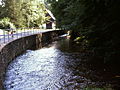
 The Bobritzsch with salt bridge between Falkenberg and Krummenhennersdorf |
||
| Data | ||
| Water code | EN : 5422 | |
| location | Saxony , Germany | |
| River system | Elbe | |
| Drain over | Freiberger Mulde → Mulde → Elbe → North Sea | |
| source | At Reichenau 50 ° 46 ′ 56 ″ N , 13 ° 35 ′ 59 ″ E |
|
| Source height | approx. 674 m above sea level NHN | |
| muzzle | At Reinsberg in the Freiberger Mulde Coordinates: 51 ° 1 '14 " N , 13 ° 20' 22" E 51 ° 1 '14 " N , 13 ° 20' 22" E |
|
| Mouth height | approx. 235 m above sea level NHN | |
| Height difference | approx. 439 m | |
| Bottom slope | approx. 12 ‰ | |
| length | 38 km | |
| Discharge at the Krummenhennersdorf gauge 1 A Eo : 130.89 km² Location: 7.1 km above the mouth |
NNQ (08/16/2000) MQ Mq MHQ HHQ (08/13/2002) |
66 l / s 1.53 m³ / s 11.7 l / (s km²) 18.9 m³ / s 160 m³ / s |
The Bobritzsch is an approximately 38 km long right tributary of the Freiberg Mulde .
course
It rises in the Osterzgebirge 5 km southeast of Frauenstein and above Reichenau on the edge of the Kreuzwald and only 600 m away from the Weicheltmühle on the Gimmlitz .
It continues through Reichenau, Kleinbobritzsch , Hartmannsdorf , Friedersdorf , Ober- and Niederbobritzsch , Naundorf , Falkenberg , Krummenhennersdorf , Reinsberg and Bieberstein .
A well-known hiking trail along the Bobritzsch between Krummenhennersdorf and Reinsberg is called the Grave Tour . Above the river there are Reinsberg Castle on the right and Bieberstein Castle on the left .
Between Reinsberg and Siebenlehn , 1 km north of Schloss Bieberstein, the river flows into the Freiberg Mulde .
Origin and meaning of the name
The name comes from the Old Sorbian Bobrica , to bobr ( beaver ) and describes a body of water in which beavers lived.
Between Ober- and Niederbobritzsch

Bridge of the B 173 in Naundorf

Arch bridge in Falkenberg built in 1567

Former Erblehnmühle at the arch bridge

Sheep bridge near Oberschaar

High water level in August 2002 at the Schafbrücke

Bridge from 1806 in Krummenhennersdorf

Reinsberg Castle in the 19th century


See also
Web links
Individual evidence
- ↑ Hydrological Handbook. (PDF; 637 kB) Part 3 - Main aquatic values. Free State of Saxony - State Office for Environment and Geology, p. 86 , accessed on December 25, 2017 .
- ↑ Flood protection in 2002 in the Mulde area, Saxon State Office for Environment, Agriculture and Geology; 2009 (PDF; 5.4)