Bockert
|
Bockert
City of Viersen
Coordinates: 51 ° 14 ′ 15 ″ N , 6 ° 22 ′ 45 ″ E
|
||
|---|---|---|
| Height : | 61–70 m above sea level NN | |
| Incorporated into: | Viersen | |
| Postal code : | 41748 | |
| Area code : | 02162 | |
|
Location of Bockert in Viersen |
||
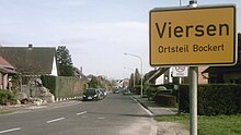
Bockert is a district of the North Rhine-Westphalian district town of Viersen .
Geography and history
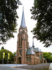
The village of Bockert is located in the Viersen urban area in the southwest of the Alt-Viersen district . Unlike the district of Hoser , which is a little further north , Bockert is no longer included in the Viersen city center, but in the southern and eastern outer areas of Alt-Viersen and therefore has the postcode 41748 (and not 41747). Earlier names for the village were Boekholt or Boukholt , which means beech wood in High German and indicates a beech forest that used to exist here . The peculiar way of speaking the Bockert or in the Bockert still reminds of this today . As far as it has been handed down, Bockert has been part of Viersen since the Middle Ages , nothing is known of any kind of communal independence. In terms of the church, however, the situation is different: Bockert is a parish village with the Catholic parish church " St. Peter " , and the neighboring Altviersen districts of Hoser and Oberbeberich also belong to the Bockert parish .


traffic
The closest passenger train stations to Bockert are Viersen and Dülken .
Road traffic
- Bockert is crossed in a north-south direction by the two-lane state road L 39 (" Hardter Straße "). The L 39 runs from downtown Altviersen via Hoser to Bockert and on via Rasseln to Mönchengladbach-Hardt .
- In a west-east direction, Hardter Straße is crossed by Kreisstraße 8 (" Bockerter Straße "), which leads from Schwalmtal - Waldniel via Mackenstein and the autobahn connection of the same name to the A 61 to Bockert and on via Beberich to Gladbacher Straße ( L 71 ).
- The closest motorway connection is the "Mackenstein" motorway junction on the A 61.
Bus transport
As a district of Viersen, Bockert is part of the tariff area of the Rhein-Ruhr transport association . The Viersener Niederrheinwerke serve the district of Bockert with a total of two bus routes:
| Type | line | route | Hints |
|---|---|---|---|
| 081 | Bockert, Kreuz ↔ Hoser ↔ Viersen, Gereonsplatz ↔ Viersen, bus station. ↔ Krefelder Str. ↔ Robend ↔ Düpp, Im Wolfhahn | Niederrheinwerke Viersen | |
| 082 | Bockert, Kreuz ↔ Hoser ↔ Viersen, Busbf. ↔ Viersen, Gereonsplatz ↔ Viersen, station ↔ Robend ↔ Düpp, Im Wolfhahn |
Niederrheinwerke Viersen , in Hoser the stop "Eigenheim" is also used. |
|
| (As of April 2011) |
Bike trails
The village of Bockert is crossed or touched by several cycle paths - partly on the same road - a total of three officially designated cycle paths lead through the village:
- The German Football Route NRW , here especially between the adventure cities of Krefeld and Mönchengladbach . Coming from Krefeld , the football route leads through the Altviersen city center and past the Viersener main cemetery, then runs west of Hoser through the fields (" Buyterste Feld ") to Bockert, further towards Bockerter Heide and then via Mönchengladbach-Rasseln finally towards Borussia -Park .
- The medlar route is a circular route around Alt-Viersen. The medlar route runs roughly from Buytersten Feld on a common road with the German Football Route NRW through Bockert to the junction towards Haus Waldfrieden in the Bockerter Heide. While the soccer route initially continues straight ahead towards Mönchengladbach, the medlar route branches off to the right and runs past Haus Waldfrieden via Bötzlöh to Helenabrunn and on towards Niers .
- The Irmgardispfad , an inner-city hiking trail for pedestrians and cyclists, on the other hand, runs independently of the two first-mentioned cycle routes on its own road over Zweorstrasse on the eastern edge of Bockert. The Irmgardis path leads from the Irmgardiskapelle in the Süchtelner heights on the western outskirts of Alt-Viersen past Hoser and the Jubilee Garden to Bockert and on via Oberbeberich , Ompert and Ummer to Helenabrunn .
Association and social life
- Protect : St. Peter and Paul Brotherhood Viersen-Bockert 1763 eV
- St.Martin : St.Martinsverein Viersen-Bockert 1891
Attractions
- Crossroads Hardter Strasse / Kreuzstrasse : The crossroads on the corner of Hardter Strasse and Kreuzstrasse is roughly in the historic center of Bockert. A chapel used to stand here, which was demolished in 1886. As an alternative, a wooden cross was erected there, but it had to be restored several times. Finally, the wooden cross was replaced in 1927 by a stone cross made of shell limestone. The cross is embedded in a small green area and has been a listed building since 2002.
- Hötte und Pötte soil monument : A short distance to the Hardter Straße / Kreuzstraße crossroads is the Hötte und Pötte soil monument, which was laid out in 1992 in a westerly direction . The name goes back to the phrase Bockert hätt fiev Hötte on si'eve Pötte , which means that there used to be five farms (Hötte) and seven wells (Pötte) in Bockert. The names of the farms and fountains are symbolized with colored floor tiles. The existence of the wells made the development of the district possible in the first place, because unlike in all other Viersen districts, there was never any flowing water here.
- Viersen Jubilee Garden : The so-called Jubilee Garden is located between Bockert and Hoser . This is a small park in which interested and inclined citizens can plant or have a tree planted on the occasion of their personal anniversaries (birthdays, wedding anniversaries, etc.). In addition, a number of interesting play equipment for children has been set up in the anniversary garden.
The closer environment
| Dulken | Panties | Sub-division |
| Bergerstrasse |

|
Oberbeberich |
| MG rattles | Bockerter Heide Bötzlöh | Ompert |
Web links
- Official website of the city of Viersen
- Official website of the district of Viersen
- Association for Home Care eV Viersen
Individual evidence
-
↑ Topographic map 1: 25000, sheet 4704 (Viersen) (published by the state of North Rhine-Westphalia, accessed on March 23, 2019)
-
↑ Ferdinand Dohr: Die Viersener Landwehr , published in the Heimatbuch des Kreis Kempen-Krefeld 1972
(now: Heimatbuch des Kreis Viersen , ISSN 0948-6631 , accessed on October 29, 2013) -
↑ Excerpt from the club chronicle - prehistory of the community
(website of the St.Petri Schützenbruderschaft von 1753 Viersen-Hoser eV, accessed on April 8, 2011) - ↑ Irmgardispfad - Lie'nepäsch (Helenenpfad) (official website of the city of Viersen, accessed on April 15, 2011)
- ↑ Homepage of the St. Peter and Paul Brotherhood Viersen-Bockert 1763 eV (accessed on April 8, 2011)
- ↑ Internet site of the St.Martinsverein Viersen-Bockert 1891 (accessed on April 8, 2011)
- ↑ Monuments: Wegekreuz Hardter Straße / Kreuzstraße (official website of the city of Viersen, accessed on April 8, 2011)
- ↑ City gardens: Viersen's gardens ( Memento of the original from April 29, 2011 in the Internet Archive ) Info: The archive link was inserted automatically and has not yet been checked. Please check the original and archive link according to the instructions and then remove this notice. (official website of the city of Viersen, accessed on April 9, 2011)


