Robend
|
Robend
City of Viersen
Coordinates: 51 ° 15 ′ 25 ″ N , 6 ° 24 ′ 50 ″ E
|
||
|---|---|---|
| Height : | 34–38 m above sea level NHN | |
| Incorporated into: | Viersen | |
| Postal code : | 41748 | |
| Area code : | 02162 | |
|
Location of Robend in Viersen |
||
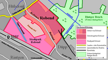
Robend (actually: the Robend , occasionally also the Robend ) is a district of the North Rhine-Westphalian district town of Viersen . Within the Viersen urban area, the district of Robend belongs to the district of Alt-Viersen and is located approx. 1.5–2 km east of the Altviersen city center. Within North Rhine-Westphalia, Robend also belongs to the Lower Rhine region and, as a district of Viersen, also belongs to the Rhine-Ruhr metropolitan region .
Earlier names for the area were alde Benden , alde finishing , in high German translation also old Benden , also Rabenden or Rabend . As far as it is known, the area of Robend was part of the Altviersener Honnschaft Rintgen since the Middle Ages , nothing is known of any local political independence.
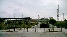
Since 2001, the district of Robend has been considerably enlarged in a south-westerly direction by the new development area Stadtpark Robend , so that the development now almost extends as far as the Viersen train station .
Etymology and history

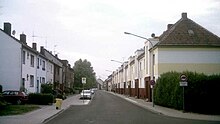
The area of the Robend was once called " the old Benden " in different variations ( see above! ) . Here designated Bend originally a temporarily locked against grazing hay meadow. A few larger farms had been located there since at least the 16th century . At the beginning of the 19th century , a street village called " Rabenden " had already developed along today's street Robend . It is assumed that the name Rabenden originated from Rath - Benden , and developed through " Rabend " to today's Robend . In the course of the 20th century the development of the Robend became more and more dense, so that finally the almost complete, predominantly multi-family houses along the street " Robend " emerged as we know it today.
Robend City Park
Beyond the Robender Feld , an agricultural open space in the southwest of Robend, the originally quite extensive loading area of the Viersen freight yard was built in the 20th century . After the end of World War II , Viersen became part of the British occupation zone and the British Rhine Army , whose headquarters were in nearby Mönchengladbach , set up a military depot area between the Viersen freight yard and Robender Feld with a connection to the German railway network . This depot was finally abandoned after the end of the Cold War in 1995. The loading and maintenance facilities of the Viersen freight station were also shut down and demolished in the following years , creating a large open space between Robender Feld and the railway embankment with the remaining railway line including the passenger station at the end of the 1990s . The new urban park Robend district has gradually been built on this open space since 2001 .
As an urban highlight, a section of the former north canal was restored. The Hageau Promenade , named after the chief engineer of the historic North Canal project, Aimable Hageau, extends along this restored canal section as one of two main axes of this traffic-calmed new development area . In memory of the original plans for the north canal (a route to Antwerp was actually intended ), a number of other streets in the area were named after today's Belgian or Dutch cities and areas, such as B. Bruxelles Allee , Flämische Allee or Limburgweg .
As part of the construction work, a tunnel was also built under the adjacent railway embankment in the Viersen station building; Since then, the Viersen train station can also be entered from the east (from the direction of Robend City Park).


traffic
Road traffic
The area of Robend is touched on the northern edge of the North Rhine-Westphalian state road L29, this is the former federal road 7 , which is also called " Krefelder Straße " here . The L29 connects Robend to the west with the Alt-Viersen city center, to the east with the Willich district of Neersen , where there is also a connection to the A44 .
Rail transport
passenger traffic
The railway lines from Mönchengladbach to Duisburg and from Mönchengladbach to Venlo run on a joint embankment on the southern edge of the new urban park Robend . A newly built pedestrian tunnel leads from the Robend city park directly to Viersen station , where you can board a regional train and two regional express lines:RE 11, RE 13 or. RB 33.
Freight transport
From a junkyard on the eastern edge of Robend, a freight track also leads at ground level to the southeast , where it branches off from the embankment of the main railway line beyond the neighboring district of Düpp .
Bus transport
As a district of Viersen, the area Robend / Stadtpark Robend belongs to the tariff area of the Verkehrsverbund Rhein-Ruhr . The BVR bus Rheinland GmbH and the low Viersen serve the area with a total of six bus lines. This means that Robend / Stadtpark Robend has direct connections with most of Viersen. The two BVR lines also link the area with all four districts of the neighboring city of Willich as well as with the Düsseldorf suburbs of Meerbusch and Kaarst , where there is a connection to the light rail or S-Bahn network:
| Type | line | route | Hints |
|---|---|---|---|
| 071 |
Viersen, bus station. - Viersen, Gereonsplatz - Krefelder Str./Kanalstr. - Krefelder Str./Robend - Anrath - Willich - Meerbusch , Haus Meer |
Bus traffic in Rhineland , stops in the Robend area: Krefelder Str./Kanalstr. , Krefelder Str./Robend . At Haus Meer there is a connection to the Düsseldorf light rail . | |
| 081 | Düpp, Im Wolfhahn - Robend - Krefelder Str./Kanalstr. - Viersen, bus terminal. - Viersen, Gereonsplatz - Hoser - Bockert, Kreuz | Niederrheinwerke Viersen , stops in the Robend area: Krefelder Str./Kanalstr. , Krefelder Str./Robend , Elkanweg , Robend Mitte , Stadtwaldallee . | |
| 082 | Düpp, Im Wolfhahn - Robend, Stadtwaldallee - Viersen, train station - Viersen, Gereonsplatz - Viersen, bus station. - Hoser - Bockert, cross | Niederrheinwerke Viersen , stops in the Robend area: Stadtwaldallee . | |
| 083 | Dülken, Am Drouvenhof - Viersen, bus station. - Viersen, Gereonsplatz - Viersen, train station - Krefelder Str./Kanalstr. - Rahser - Sittard - addicts , adolescent psychiatry | Niederrheinwerke Viersen , stops in the Robend area: Krefelder Str./Kanalstr. | |
| 087 | Beberich, Berliner Höhe - Viersen, Gereonsplatz - Viersen, bus station. - Krefelder Str./Kanalstr. - Rahser, Notburgastr. | Niederrheinwerke Viersen , stops in the Robend area: Krefelder Str./Kanalstr. | |
| 094 |
Viersen, bus station. - Krefelder Str./Gillessen - Krefelder Str./Kanalstr. - Krefelder Str./Robend - Neersen - Schiefbahn - Kaarster See |
Bus traffic in Rhineland , stops in the Robend area: Krefelder Str./Kanalstr. , Krefelder Str./Robend . At Kaarster See there is a connection to the S28 S-Bahn line (" Regiobahn "). | |
| Status: October 2011 | |||
Bike trails
In the original Robend (essentially the street of the same name) there are no official cycle paths, but three themed routes of the North Rhine-Westphalian cycle path network run through the new urban park Robend :
- The international cycling route Fietsallee on the North Canal on the way from Donk towards Süchteln .
- The German Football Route NRW , here especially between the adventure cities of Krefeld and Mönchengladbach .
- In addition , a section of the Euroga cycle path system runs here between Neuwerk-Donk and Süchteln on a common road with Fietsallee on the north canal .
For the Fietsallee on the north canal (or the Euroga cycle route), the section on the Hageau promenade along the north canal, which has been reconstructed here, is naturally one of the highlights of this themed route. In the area of the menhir facility " Anatol's Stone Circle ", which is located directly on the canal , there is also an information point and a small rest area for cyclists.
sport and freetime
- Soccer : Germaniastadion on Krefelder Strasse
- The youth teams of the district actually Rahser -based SC Viersen Rahser held here from their home games.
Attractions
Anatol's stone circle
As part of Euroga 2002/2003, a North Rhine-Westphalian state horticultural show organized in a decentralized manner at the time , the sculptor Anatol Herzfeld erected a stone circle of ten large boulders with a circumference of approx. 400 m on the north canal reconstructed in the Robend city park. The boulders came from the vicinity of Viersen's Brandenburg twin town Calau . On the edge of the stone circle there is also the information point " bridge keeper's house " to Fietsallee on the north canal , although the bridge keeper's house is approx. 150 m further north.
Bridge keeper's house
The former bridge keeper's house of the North Canal project is located at Antwerp Square No. 1. The building, which was erected in 1810, has been a listed building under the list number 366 since 1998.
The closer environment
| Rakers | Clörath |
Anrath Vennheide |
| Hülsdonk |

|
Neersen |
| Rintgen |
Hamm Ummer |
Duff Donk |
Web links
- Official website of the city of Viersen
- Official website of the district of Viersen
- Association for home care e. V. Viersen
- Stadtpark Robend - Living on the Nordkanal (official website of the development company of the city of Viersen mbH )
Individual evidence
-
↑ a b c d e f g h i Peter Norrenberg : From the Viersener Bannbuch, Viersen 1886
(online presentation of the university library of the Heinrich Heine University Düsseldorf , accessed on October 31, 2011) - ↑ strassenkatalog.de: Robend in 41748 Viersen (accessed on October 31, 2011)
-
↑ City of Viersen: Minutes No. 3/2010 on the meeting of the regulatory and road traffic committee on Monday, July 12, 2010 (PDF; 26 kB)
(official website of the city of Viersen, accessed on October 31, 2011) -
↑ a b topographic map 1: 25000, sheet 4704 (Viersen)
(published by the state of North Rhine-Westphalia, accessed on March 23, 2019) -
↑ Topographic map 1: 100000, sheet C4702 (Krefeld) ( Memento of the original from October 29, 2013 in the Internet Archive ) Info: The archive link was inserted automatically and has not yet been checked. Please check the original and archive link according to the instructions and then remove this notice. (4th edition, published in 1989, published in 1981 by the Land Survey Office of North Rhine-Westphalia (now: Cologne District Government), accessed on October 30, 2013)
- ↑ Online world map of the OpenStreetMap Foundation (accessed on October 31, 2011)
-
↑ Ferdinand Dohr: Die Viersener Landwehr , published in the Heimatbuch des Kreis Kempen-Krefeld 1972
(now: Heimatbuch des Kreis Viersen , ISSN 0948-6631 , accessed on October 29, 2013) -
↑ a b c Map of the Rhineland 1: 25000 by Tranchot and v. Müffling (1803–1820), sheet 42 (Viersen) ( Memento of the original from October 29, 2013 in the Internet Archive ) Info: The archive link was inserted automatically and has not yet been checked. Please check the original and archive link according to the instructions and then remove this notice. (Reprinted in 1966 by the Land Surveying Office of North Rhine-Westphalia, Bonn-Bad Godesberg (now: Cologne District Government), accessed on October 30, 2013)
- ↑ a b Davids | Ter Frucht + Partner: Transformation + Industrielandschaft, Stadtgarten Robend Viersen (accessed on October 31, 2011)
- ↑ a b Stadtpark Robend - Wohnen am Nordkanal (official website of the development company of the city of Viersen mbH , accessed on October 31, 2011)
- ↑ Werner Grasediek: Desolations in the area of Steffeln. In: Heimatjahrbuch 1987. Landkreis Vulkaneifel, accessed on April 8, 2019 .
-
↑ Prussian map recording 1: 25000 - first recording (1844) -, sheet 4704 (Viersen)
(reprint, published in 1991 by the state survey office of North Rhine-Westphalia, Bonn-Bad Godesberg (now: Cologne district government), accessed on March 23, 2019) -
↑ German basic map map 1: 5000, sheets 4704/08 (Viersen, Hülsdonk) and 4704/13 (Viersen, Hamm) ( Memento of the original from November 3, 2013 in the Internet Archive ) Info: The archive link was inserted automatically and has not yet been checked . Please check the original and archive link according to the instructions and then remove this notice. (Published 2011 by the State of North Rhine-Westphalia, accessed on October 30, 2013)
-
↑ Development plan No. 187 "Südlich des Steinkreises / Flämische Allee / Hageau-Promenade" / Explanation (PDF; 7.6 MB)
(official online presentation of the city of Viersen, accessed on October 31, 2011) - ^ Mining and railways in the Aachen-Düren-Heinsberg region : Mönchengladbach - Viersen - Venlo (accessed on October 31, 2011)
- ↑ Farewell to the B 7 ( page no longer available , search in web archives ) Info: The link was automatically marked as defective. Please check the link according to the instructions and then remove this notice. (Rheinische Post from August 2, 2010, page C1 (" Grenzland-Kurier "), accessed on October 30, 2011)
-
↑ a b Radwandern im Kreis Viersen , Radwanderung 1: 50,000, 4th edition 2009
(published by Bielefelder Verlag GmbH & Co. KG; Bielefeld and Wirtschaftsförderungsgesellschaft für der Kreis Viersen mbH, Viersen , ISBN 978-3-87073-122-9 ) - ↑ a b ADFC regional map: Niederrhein-Süd , 1: 75,000, Bielefelder Verlag, ISBN 978-3-87073-318-6
- ↑ About us ( Memento of the original from January 3, 2013 in the Internet Archive ) Info: The archive link was inserted automatically and has not yet been checked. Please check the original and archive link according to the instructions and then remove this notice. (Internet presence of SC Viersen Rahser 1954 eV , accessed on October 31, 2011)
- ↑ Euroga projects: Steinkreis (official website of the city of Viersen, accessed on November 1, 2011)
- ↑ Monuments: Bridge Keeper's House Nordkanal (official website of the city of Viersen, accessed on November 1, 2011)


