Braunsdorf (Niederwiesa)
|
Braunsdorf
Niederwiesa municipality
Coordinates: 50 ° 52 ′ 47 " N , 13 ° 0 ′ 41" E
|
||
|---|---|---|
| Height : | 280 m | |
| Area : | 1.93 km² | |
| Residents : | 700 | |
| Population density : | 363 inhabitants / km² | |
| Incorporation : | July 1, 1995 | |
| Postal code : | 09577 | |
| Area code : | 037206 | |
|
Location of Braunsdorf in Saxony |
||
Braunsdorf is a part of the municipality Niederwiesa in the district of central Saxony . It was incorporated on July 1, 1995. The landmark of the place is the water tower built in 1910 .
geography
Geographical location and traffic
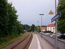
The Zschopau encloses the place in the west in an arch, at the beginning and end of which there is a weir . The river separates the corridors of Braunsdorf and Lichtenwalde. Braunsdorf is on the Roßwein – Niederwiesa railway line , which was reopened in December 2004 by the Chemnitz City Railway as a pre- runway for the Chemnitz Stadtbahn to Hainichen . The "Braunsdorf-Lichtenwalde" stop and the Harrasfelsen with the Harra tunnel are located in the local area .
Neighboring places
| Lichtenwalde | Niederlichtenau | Altenhain |
| Lichtenwalde |

|
Altenhain |
| Niederwiesa | Flea |
history
Braunsdorf was founded around 1330 as a single row forest hoof village as the last place downstream of the Zschopau from the old Schellenburg / Augustusburg . After 1474 Braunsdorf was temporarily under the lordship of the Lichtenwalde manor or, as an administrative village, directly to the Electoral Saxon Office of Lichtenwalde , which was administered from 1696 by the Electoral Saxon Office of Frankenberg-Sachsenburg and from 1783 by the Electoral Saxon or later Royal Saxon Office of Augustusburg . After the end of the Saxon constitution of offices in 1856, Braunsdorf was under the jurisdiction of the Frankenberg court office and, from 1875, of the Flöha administration . As early as 1480, a mill on the upper weir was handed down, which is known today as the weaver mill. Today it is the largest employer in town. Not far from the weaver mill, a spinning factory was established around 1800, which was later used as a felt factory and after 1910 as an upholstery weaving mill. The Braunsdorf-Lichtenwalde stop was opened on March 1, 1869 with the Niederwiesa– Hainichen section of the Roßwein – Niederwiesa railway line. The Harra tunnel , located in the nearby Haustein, called Harrasfelsen , became famous after a serious railway accident on December 14, 1913.
In 1912 the first villas and the water tower were built in the colony, today's Harrasallee.
As a result of the second district reform in the GDR , the community of Braunsdorf became part of the Flöha district in the Chemnitz district (renamed the Karl-Marx-Stadt district in 1953 ), which was continued as the Saxon district of Flöha from 1990 and in 1994 in the Freiberg district or in the year In 2008 in the district of Central Saxony. On July 1, 1995 Braunsdorf was incorporated into Niederwiesa. The place is always affected at high water levels. During the flood of the century in 2002 , Saxony's first helicopter rescue took place in Braunsdorf on August 12th. The regionally famous five-man bridge leads over the Zschopau to Lichtenwalde . It got its name from the toll of 5 pfennigs that was once payable and is reminiscent of the customs duties that were often required on bridges in the past. The bridge was severely damaged in the flood of the century in 2002 and had to give way to a new building, which was inaugurated in December 2006.
Development of the population
|
|
|
Attractions
Braunsdorf is best known for its numerous restaurants and good hiking opportunities. Also worth seeing is the nearby Lichtenwalde Castle with its park, the weaving museum in the old Tannenhauerfabrik and the Harras rock downriver, made famous by the Harrassage ( jump saga ).
The largest employer in town is the traditional Webermühle. The Hohenstein-Ernstthal- based Cammann Gobelin Manufactory also produces here .
literature
- The middle Zschopau area (= values of our homeland . Volume 28). 1st edition. Akademie Verlag, Berlin 1977, pp. 39-40.
Individual evidence
- ↑ Braunsdorf's private website
- ↑ StBA: Changes in the municipalities of Germany, see 1995
- ^ Karlheinz Blaschke , Uwe Ulrich Jäschke : Kursächsischer Ämteratlas. Leipzig 2009, ISBN 978-3-937386-14-0 ; P. 70 f.
- ^ The Flöha district administration in the municipal register 1900
- ^ Braunsdorf on gov.genealogy.net
- ↑ See Braunsdorf in the Digital Historical Directory of Saxony
- ↑ Company information ( memento of the original from August 18, 2016 in the Internet Archive ) Info: The archive link was automatically inserted and not yet checked. Please check the original and archive link according to the instructions and then remove this notice.
Web links
- Braunsdorf in the Digital Historical Directory of Saxony
- Braunsdorf on the website of the Niederwiesa municipality
- Friends of Braunsdorf im Zschopautal e. V.


