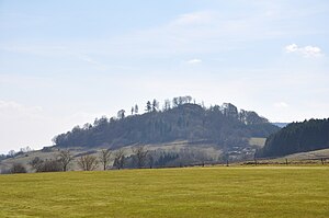
Burgberg (Schauenburg)
| Castle Hill | ||
|---|---|---|
|
View from the north, past the wood of the |
||
| height | 499.9 m above sea level NHN | |
| location | District of Kassel , Hesse , Germany | |
| Mountains |
Hoofer Pforte , Habichtswälder Bergland |
|
| Coordinates | 51 ° 17 ′ 3 ″ N , 9 ° 20 ′ 0 ″ E | |
|
|
||
| particularities | Schauenburg castle ruins | |
The castle hill in the Habichtswälder Bergland is 499.9 m above sea level. NHN high mountain of the Hoofer Pforte in the north Hessian district of Kassel .
geography
location
The castle hill is located in the southern center of the Habichtswälder Bergland between the Langenberge in the south and the Hohen Habichtswald in the north. It is located in the Habichtswald Nature Park between the Schauenburg districts of Breitenbach in the west and the Hoof at the foot of the mountain in the east. The partially forested mountain represents a northern branch of the Langenberge. The Fulda- tributary Bauna passes it northeast.
Natural allocation
The castle hill belongs to the natural spatial main unit group West Hessisches Berg- und Senkenland (No. 34) or in the main unit Habichtswälder Bergland (342) to the natural area Hoofer Pforte (342.01), which extends from north of the hilltop as a valley basin along the upper reaches of the Bauna Southeast pulls. The landscape leads south into the natural area Langenberg (342.02). It falls to the west into the natural area of Breitenbacher Mulde (342.10) and to the north-west into the natural area of Zierenberger Grund (342.11). To the north, the landscape turns into the natural area High Habichtswald (342.00).
Schauenburg castle ruins
On the top of the castle hill are the restored remains of the Schauenburg, which was built between 600 and 800 AD . The castle has been in ruins since around 1543, making it uninhabitable and subsequently used as a quarry.
Possibility of viewing
The view from the steep castle hill extends to the north only to the nearby Hohen Habichtswald and to the south only to the Langenberge, to the east, however, over Hoof, among other things, to the Kaufunger Wald and Hohen Meißner , and to the west, with Breitenbach in the foreground, is behind the Hinterhabichtswälder peaks south of the Wattenberg, with good visibility, even the distant Rothaargebirge as well as the Kellerwald in the southwest .
Traffic and walking
To the northeast, east and south the castle hill is passed by the Kassel – Naumburg railway line , on which the Hessencourrier runs and which is accompanied by the Hessencourrier cycle path . State road 3215 (former federal road 520 ) runs past to the south . The Habichtswaldsteig , Kassel-Steig and Märchenlandweg lead over the castle hill, to the east the Herkulesweg runs past .
Individual evidence
- ↑ Map services of the Federal Agency for Nature Conservation ( information )
- ↑ Martin Bürgener: Geographical Land Survey: The natural spatial units on sheet 111 Arolsen. Federal Institute for Regional Studies, Bad Godesberg 1963. → Online map (PDF; 4.1 MB)
- ^ Hans-Jürgen Klink: Geographical land survey: The natural space units on sheet 112 Kassel. Federal Institute for Regional Studies, Bad Godesberg 1969. → Online map (PDF; 6.9 MB)

