
Chabes
Aul
|
||||||||||||||||||||||||||||||||
|
||||||||||||||||||||||||||||||||
|
||||||||||||||||||||||||||||||||
.svg)

Chabes ( Russian Хабе́з , Kabardian Хьэбэз ) is an Aul in the Republic of Karachay-Cherkessia ( Russia ) with 6240 inhabitants (as of October 14, 2010).
geography
The place is located on the northern edge of the Greater Caucasus , the ridges of which there reach about 1300 m above sea level, about 30 km as the crow flies southwest of the republic capital Cherkessk on the left bank of the Little Selentschuk (Maly Selentschuk), a left tributary of the Kuban .
Chabes is the administrative center of the Rajons Chabesski and seat and only town in the rural community Chabesskoje selskoje posselenije. Almost all residents of the place are Circassians .

General view of the place
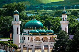
Main mosque

Hotel complex on the southern outskirts

Adijuch tower on a rock not far from the village


history
The founding year of the place is 1833, when Circassians from the Kabardine tribe finally settled there, who had been resettled several times from the area of today's Baksanjonok - east of today's city of Baksan in Kabardino-Balkaria - during the Caucasus War . The settlement was united with the already existing Aul Kirmisei of the Beslenejer tribe and as a result, like the place of origin after Prince Kassai (Kassajew) officially (Russified) called Kassajewski , Kabardian Kassai-Chabl. From 1869 the place belonged to Ujesd (from 1888 department, otdel ) Batalpaschinsk of the Oblast Kuban .
As part of the abolition of "Kabardian feudal names" after the October Revolution , the name was changed to Chabes in 1920, after a locality whose name in Kabardian-Circassian means something like "a lot of barley ". After various administrative changes, on January 23, 1935, Chabes became the seat of a Rajons named after him in the Circassian Autonomous Oblast.
During the Second World War , Chabes was occupied by the German Wehrmacht from August 1942 to January 1943 .
From May 8, 1956 until the formation of the Karachay-Cherkess Autonomous Oblast on January 9, 1957, the Chabesski rajon was temporarily dissolved.
Population development
| year | Residents |
|---|---|
| 1897 | 1543 |
| 1939 | 2603 |
| 1959 | 3353 |
| 1970 | 4479 |
| 1979 | 4770 |
| 1989 | 5308 |
| 2002 | 5781 |
| 2010 | 6240 |
Note: census data
traffic
Chabes is due to the coming of Cherkessk and Little Selentschuk up following regional road 91N-052, which is about 20 kilometers south between Kardonikskaja and Zelenchukskaya reached the 91K-006, part of the connection Maikop - Karachayevsk (previously R256).
The nearest train station by road is in Cherkessk on the Nevinnomyssk - Ust-Dscheguta branch line .
Web links
Individual evidence
- ↑ a b Itogi Vserossijskoj perepisi naselenija 2010 goda. Tom 1. Čislennostʹ i razmeščenie naselenija (Results of the All-Russian Census 2010. Volume 1. Number and distribution of the population). Tables 5 , pp. 12-209; 11 , pp. 312–979 (download from the website of the Federal Service for State Statistics of the Russian Federation)
| Cities |
Karachayevsk S / R | Teberda | Cherkessk S | Ust-Dscheguta R |
|
| Urban-type settlements |
Dombai | Elbrusski | Mednogorski | Novy Karachay | Ordzhonikidsevsky | Prawokubanski | Udarny |
|
| Other Rajon centers |
Adyge-Chabl | Chabes | Erken-Chachar | Inschitsch-Chukun | Kawkasski | Pregradnaja | Zelenchukskaya | Utschkeken |