Erken chachar
| settlement
Erken-Schachar
Эркен-Шахар ( Russian ) Эркин-Шахар ( Nogai ) Эркен-Шахер, Эркен-Щыхьэр ( Kabardian )
|
||||||||||||||||||||||||||||||||
|
||||||||||||||||||||||||||||||||
|
||||||||||||||||||||||||||||||||
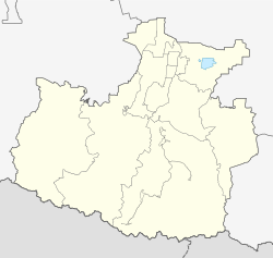
Erken-Shachar ( Russian Эркен-Шахар ; Nogai Эркин-Шахар ; Kabardian Эркен-Шахер, Эркен-Щыхьэр ) is a settlement (possjolok) in the Republic of Karachay-Cherkessia ( Russia ) with 4184 inhabitants (as of October 14, 2010).
geography
The place is located on the northern edge of the Greater Caucasus about 20 km as the crow flies northwest of the republic capital Cherkessk . It is located between the Kuban , which flows a good kilometer northeast and marks the border with the Stavropol region , and its left tributary, the Kleiner Selentschuk (Maly Selentschuk), which flows about three kilometers to the northwest.
Erken-Shachar is the administrative center Rajons Nogaiski and seat of the rural community posselenije Erken-Schacharskoje selskoje, also to the north of the immediately subsequent Aul belongs Kuban Chalk. Almost half of the population are Nogai , a good quarter are ethnic Russians , while Circassians and Abasins predominate among the rest .
history
The history of the place begins with the construction of the railway line from Nevinnomyssk to Batalpashinsk, today's Cherkessk, in 1925 (later extended to Ust-Dscheguta ). In 1928, not far from Auls Erken-Chalk , which is just under two kilometers to the west, the construction of the Erken-Schachar train station (Russified from Nogai for "Free City") began and an initially temporary workers' settlement was established. In 1929 the Aul Kuban-Chalk, now part of the municipality, was built east of the railway line and was founded by resettlers from Erken-Chalk. In the 1930s, the first businesses and infrastructure facilities came into being at the station settlement. From January 23, 1935, the settlement belonged to the Ikon-Chalkski rajon, which had been expelled in the northern part of the then Circassian Autonomous Oblast, which was predominantly populated by Nogai people, initially in Ikon-Chalk 8 km to the south-west, and from November 1936 in the nearby Adyge-Chabl .
On May 8, 1956, the Rajon was dissolved and its localities initially placed directly under the Autonomous Oblast; on January 15, 1957 they came to the newly expelled Adyge-Chablski rajon. The settlement Erken-Shachar belonged to the Adyge-Khabl village soviet . By decision of the Council of Ministers of the USSR in 1959, the construction of one of the largest sugar factories in the country and, from March 1961, an associated housing estate began at the train station . This received the status of an urban-type settlement on May 8, 1962 , which was thus separated from the village soviet. The year the factory and the settlement were completed, 1964, is now celebrated as the year the town was founded. Up until the 1970s, other businesses emerged, in particular factories for yeast and animal feed .
In 1992 the place was converted into a rural settlement. Since October 12, 2007 it has been the administrative seat of the Nogaiski rajon, which has been separated from the Adyge-Chablski rajon within the new borders.
Population development
| year | Residents |
|---|---|
| 1970 | 4840 |
| 1979 | 5067 |
| 1989 | 4974 |
| 2002 | 4152 |
| 2010 | 4184 |
Note: census data
traffic
The Kotschubejewskoje - Cherkessk branch of the R217 Kawkas federal highway runs southwest of Erken-Shachar . In a southerly direction, the regional road 91N-008 branches off to the neighboring district center of Adyge-Chabl, only five kilometers away.
In the village there is a train station at kilometer 31 of the branch line Nevinnomyssk - Ust-Dscheguta.
Web links
Individual evidence
- ↑ a b Itogi Vserossijskoj perepisi naselenija 2010 goda. Tom 1. Čislennostʹ i razmeščenie naselenija (Results of the All-Russian Census 2010. Volume 1. Number and distribution of the population). Tables 5 , pp. 12-209; 11 , pp. 312–979 (download from the website of the Federal Service for State Statistics of the Russian Federation)

