
Khomutovka (Kursk)
| Urban-type settlement
Khomutovka
Хомутовка
|
||||||||||||||||||||||||||||||||
|
||||||||||||||||||||||||||||||||
|
||||||||||||||||||||||||||||||||
.svg)

Chomutowka ( Russian Хомутовка ) is an urban-type settlement in the Kursk Oblast in Russia with 4230 inhabitants (as of October 14, 2010).
geography
The place is a good 110 km as the crow flies west-northwest of the Kursk Oblast Administrative Center , 8 km from the border with Bryansk Oblast and just under 15 km from the state border with Ukraine . It is located on the Chatuscha, which joins 8 km north with the Romanowski brook to Sew , a left tributary of the Nerussa .
Khomutovka is the administrative center Rajons Chomutowski and seat of the municipality (gorodskoje posselenije) Possjolok Khomutovka, which also includes the 3 km south location Weiler (Khutor) belongs Jelisawetinski.

Levschin manor from the 18th century
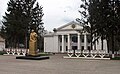
House of Culture and Lenin Monument

school
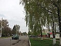
Street in Khomutovka


history
The place was founded in 1686 as Sloboda Komarizki Cholm . Later it was called Sokolje or Sokolowka until the current name came into use in the first half of the 18th century. As a result, the place belonged to Ujesd Dmitrijew and after its dissolution in 1924 briefly to Ujesd Rylsk of the Kursk Governorate until it became the administrative seat of a newly created Rajon named after him on July 30, 1928.
During the Second World War , Chomutowka was occupied by the German Wehrmacht in mid-October 1941 . In the run-up to the Battle of Kursk in July 1943, the place was a few months near the front, a little west of the line to which the Red Army was able to advance in the spring of 1943 after the reconquest of Kursk. Khomutovka was finally liberated on August 26, 1943 in the early stages of the Battle of the Dnieper .
In 1967 the place received the status of an urban-type settlement.
Population development
| year | Residents |
|---|---|
| 1939 | 2182 |
| 1959 | 2647 |
| 1970 | 3990 |
| 1979 | 4953 |
| 1989 | 5578 |
| 2002 | 5050 |
| 2010 | 4230 |
Note: census data
traffic
About five kilometers west of Chomutowo, the A142 branches off the federal trunk road M3 Moscow - Bryansk - Ukrainian border (further in the direction of Kiev ) , a cross connection to the M2 at Trosna . In a southerly direction the regional road 38K-040 branches off to the neighboring district center of Rylsk.
The nearest train station can be reached via the A142 in Dmitrijew-Lgowski , which is 40 km away, to the northeast, on the Bryansk - Lgov - Kharkiv route (Ukraine).
Web links
Individual evidence
- ↑ a b Itogi Vserossijskoj perepisi naselenija 2010 goda. Tom 1. Čislennostʹ i razmeščenie naselenija (Results of the All-Russian Census 2010. Volume 1. Number and distribution of the population). Tables 5 , pp. 12-209; 11 , pp. 312–979 (download from the website of the Federal Service for State Statistics of the Russian Federation)
| Cities |
Dmitriev-Lgovsky R | Fatesch R | Kursk S / R | Kurchatov S / R | Lgow S / R | Obojan R | Rylsk R | Zheleznogorsk S / R | Shchigry S / R | Sudscha R |
|
| Urban-type settlements |
Khomutowka R | Glushkovo R | Gorschechnoye R | in the. Karla Libknechta | Ivanino | Kastornoje R | Kirowski | Konyschowka R | Korenewo R | Kschensky R | Magnitny | Medvenka R | Novokastornoe | Olymski | Ponyri R | Pristen R | Prjamitsyno R | Solnzewo R | Solotuchino R | Tim R | Tjotkino | Cheremissinovo R |
|
| Other Rajon centers |