Concepción District (Vilcas Huamán)
| Concepción District | |
|---|---|
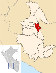
 The district of Concepción is located in the northeast of the province of Vilcas Huamán (marked in red) |
|
| Basic data | |
| Country | Peru |
| region | Ayacucho |
| province | Vilcas Huamán |
| Seat | Concepción |
| surface | 229 km² |
| Residents | 1766 (2017) |
| density | 7.7 inhabitants per km² |
| founding | November 19, 1954 |
| ISO 3166-2 | PE-AYA |
| politics | |
| Alcalde District | Heráclides Vásquez Góme (2019-2022) |
| Political party | Movimiento Regional Gana Ayacucho |
Coordinates: 13 ° 32 ′ S , 73 ° 52 ′ W
The Concepción district is located in the Vilcas Huamán province in the Ayacucho region in south-central Peru . The district was established on November 19, 1954. It has an area of 229 km². The 2017 census counted 1766 inhabitants. In 1993 the population was 2262, in 2007 2885. The seat of the district administration is the 3050 m high village of Concepción with 279 inhabitants (as of 2017). Concepción is located 16 km northeast of the provincial capital Vilcas Huamán .
Geographical location
The district of Concepción is located in the Andean highlands in the northeast of the province of Vilcas Huamán. The Río Pampas flows north along the eastern district boundary.
The district of Concepción borders in the south with the district Vilcas Huamán , in the west with the district Vischongo , in the north with the district Ocros ( province Huamanga ) and in the east with the districts Huaccana , Chincheros and Cocharcas (all three in the province Chincheros ).
Localities
In addition to the main town, there are the following larger towns in the district:
- Astanya
- Chacari
- Collaspampa
- Huaracayoq
- San Antonio de Pirhuabamba
- San Pedro de Tantar
- Santa Rosa de Qochamarca
- Virgen del Carmen de Pacomarca
Web links
- Peru: Ayacucho region (provinces and districts) at www.citypopulation.de
- INEI Perú