Cornwallis Island (Canada)
| Cornwallis Island Cornwallis Island |
|
|---|---|
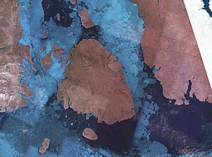
| Cornwallis Island satellite image | |
| Waters | Arctic Ocean |
| Archipelago | Queen Elizabeth Islands |
| Geographical location | 75 ° 6 ′ N , 94 ° 53 ′ W |
| length | 115 km |
| width | 100 km |
| surface | 6th 995 km² |
| Highest elevation | (unnamed) 359 m |
| Residents | 299 (2006) <1 inh / km² |
| main place | Resolute Bay |
| Map of the island | |
The Cornwallis Island ( English Cornwallis Island ) is one of the Queen Elizabeth Islands in the Canadian territory of Nunavut .
It is north of Somerset Island , between Devon Island in the east and Bathurst Island in the west. It has a size of 6995 km² and a coastline of about 636 km, it is about 115 km long and between 50 and 100 km wide. The island is relatively flat. The terrain rises slowly from northwest to southeast and reaches a maximum height of 359 m above sea level ten kilometers west of Depot Point .
The island was visited in 1819 by William Edward Parry , who named it after William Cornwallis , a British admiral . In 1850/51 William Penny and John Ross spent the winter in Assistance Bay on the southern tip of the island in search of the missing Franklin expedition . The following spring, most of the coastline was mapped. Nevertheless, the Cornwallis Island was still considered the Bathurst Island peninsula until 1859.
The settlement Resolute ( Inuktitut : Qausuittuq ) is located on the south coast at 74 ° 42 'north latitude and 94 ° 34' west longitude, has an airfield and acts as a hub for the central Arctic islands of Nunavut. The place has about 200 inhabitants and is the second northernmost permanent settlement in Canada. It was founded in 1947 as a Canadian-American weather station . In 1954, Inuit were resettled by the government from other areas to Resolute because there was more game here. The place is named after the ship HMS Resolute , one of the ships that searched for the missing expedition of John Franklin in the middle of the 19th century .
Web links
- Cornwallis Island ( English, French ) In: The Canadian Encyclopedia .
Individual evidence
- ↑ The Atlas of Canada - Sea Islands ( Memento from October 6, 2012 in the Internet Archive ) (English)
- ^ Resolute Community Profile. Census 2016. In: Statistics Canada . June 21, 2019, accessed on July 27, 2020 .


