
Creuzburger Werra breakthrough
| Creuzburger Werra breakthrough | ||
|---|---|---|
 The Werra breakthrough between Creuzburg and Buchenau |
||
| location | Thuringia , Germany | |
| Waters | Werra | |
| Geographical location | 51 ° 3 '34 " N , 10 ° 15' 56" E | |
|
||
| rock | Shell limestone | |

The Creuzburger Werra Gorge is a breakthrough valley of the Werra near Creuzburg in the Wartburg district in Thuringia .
location
The Werra breakthrough in the broader sense begins at the western Thuringian Gate near Hörschel between the Zickelsberg , a branch of the Kielforst in the west and the Hörschelberg in the east. Then the valley widens and forms a small basin near Wilhelmsglücksbrunn .
From Creuzburg in the direction of Mihla , the actual narrow valley route begins with its steep slopes, which are strongly structured by small side valleys. The valley is initially flanked to the northwest by the Ebenau Heads and to the southeast by the Nordmannssteins as the northwest pillar of the Mihlberg , and the Werra flows through it from southwest to northeast. At Mihla the Werra changes direction with a sharp bend and continues to flow in a north-westerly direction until shortly before Treffurt , where the Lower Werra Valley begins. The Iberg and the Kahn near Falken form the end .
In the valley next to the Werra, the state road 1017 runs from Creuzburg to Mihla and the route of the former Schwebda – Wartha railway line , which today carries the Werra valley cycle path . In the valley are the towns of Ebenau , Buchenau , Freitagszella and Ebenshausen , which belong to the town of Amt Creuzburg , and the community of Frankenroda .
Natural structure
The Creuzburg Werra breakthrough divided as part of the eastern continuation of Ringgau natural area as follows:
- for 47/48 Thuringian basins (with edge plates)
The Werra breakthrough separates the Ringgau in the narrower sense in the west from the Creuzburg – Eisenacher Graben in the southeast, which is also included in the West Thuringian mountain and hill country and the Falkener Platte in the northeast.
The Thuringian State Institute for Environment and Geology (TLUG) has a somewhat coarser natural system, according to which the Creuzburg Werra breakthrough lies in the unit Werrabergland-Hörselberge .
Geology and conservation
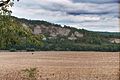
The entire valley section is part of the Eichsfeld-Hainich-Werratal Nature Park . The surrounding mountains consist of shell limestone , through which the Werra broke its course and created the prominent rock projections ("heads") that exist today. The northern Nordmannsteine in the Buchenau district have been used for limestone mining since the 1920s. The Nordmannsteine are part of the Klosterholz-Nordmannsteine nature reserve .
The following nature reserves exist in this area of the Werra Valley:
- NSG Klosterholz and Nordmannssteine , 139 hectares (1961)
- NSG Ebenauer Köpf und Wisch , 45 ha (1996)
- NSG Probsteizella , 25 ha (1961)
- NSG Lienig , 22 ha (1961)
- NSG Wilhelmsglücksbrunn , 77 ha (2000)
gallery
The Ebenau heads
Werra breakthrough with Nordmann stones

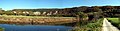
The Werra above the Werra bridge at Creuzburg


Individual evidence
- ↑ H.-J. Klink: Geographical survey: The natural units on sheet 112 Kassel - Federal Institute for Regional Studies, Bad Godesberg 1969 → online map
-
^ Walter Hiekel, Frank Fritzlar, Andreas Nöllert and Werner Westhus: The natural spaces of Thuringia . Ed .: Thuringian State Institute for Environment and Geology (TLUG), Thuringian Ministry for Agriculture, Nature Conservation and Environment . 2004, ISSN 0863-2448 . → Natural area map of Thuringia (TLUG) - PDF; 260 kB → Maps by district (TLUG)
- ↑ Map services of the Federal Agency for Nature Conservation ( information )