Klosterholz and Nordmannssteine
|
Klosterholz and Nordmannssteine
|
||
|
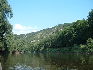
View from the Werra to the Klosterholz and Nordmannssteine nature reserve |
||
| location | Thuringia , Germany | |
| surface | 139.1 ha | |
| Identifier | 24 | |
| WDPA ID | 164150 | |
| Geographical location | 51 ° 3 ' N , 10 ° 16' E | |
|
|
||
| Setup date | 1961 | |
The nature reserve Klosterholz and Nordmannssteine is located in the Wartburg district in Thuringia . It extends north, east and south of Ebenau , a district of the city of Amt Creuzburg . The Werra flows on the western edge of the area in the area of the Creuzburg Werra Gorge , the state road L 1017 runs to the west and the B 7 runs to the southwest .
In the nature reserve, the Ebenau cliffs rise up from the valley floor as a striking rock face. A quarry has been operating on its northern edge since the 1920s. This was closed and renatured in 2013. The complete renaturation was completed by the end of 2014, including a near-natural lake.
Legal status
The 139.1 ha area with the NSG no. 24 was placed under nature protection in 1961. The Protected Area Ordinance was revised in November 2017 and the layout of the area was slightly changed. Among other things, the route of the Werra Valley cycle path , which ran on the former Schwebda – Wartha railway line, was removed from the area.
See also
Web links
- World Database on Protected Areas - Klosterholz und Nordmannssteine (English)
- Nature reserves (status: 03/2018) (including core and maintenance zones of the "Rhön" biosphere reserve) on tlug-jena.de, accessed on February 13, 2019
Individual evidence
- ^ Renaturation in the Buchenau quarry rated as successful , Thüringer Allgemeine, December 10, 2014
- ↑ Thuringian Ordinance on the "Klosterholz und Nordmannssteine" nature reserve of November 13, 2017. Thuringian State Gazette, page 357


