
Werraaue Treffurt
|
Werraaue Treffurt
|
||
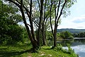
 View from the Heldrastein over the meadow between Treffurt (right in the picture) and Heldra (left). |
||
| location | Southwest of Treffurt in the Wartburg district in Thuringia | |
| surface | 68.5 hectares | |
| Identifier | 208 | |
| WDPA ID | 166254 | |
| Geographical location | 51 ° 8 ' N , 10 ° 13' E | |
|
||
| Sea level | from 171 m to 180 m | |
| Setup date | 1995 | |
| particularities | Special protection as a nature reserve and part of a flora-fauna-habitat area as well as the “ Green Belt ”. | |

The Werraaue Treffurt stretches across the bottom of the Werra Valley , directly on the Thuringian - Hessian border. It contains water-filled former gravel pits with extensive reed beds and large sedge beds that have become habitats for birds and amphibians . The biotopes and species that the floodplain are home to are considered to be worthy of protection because of their special nature. In order to preserve them and to keep disturbances away from them, the Thuringian state administration office , as the higher nature conservation authority , declared the area a nature reserve in June 1996 . The Werra was included in the protected area with a length of around one kilometer, in its entire width. As one of the “pearls” of the “ Green Belt ”, the Treffurter Aue is seen as an important stepping stone in the biotope network along the Werra. The protected floodplain area continues on the Hessian side with the nature reserve " Frankenloch bei Heldra ".
location
The floodplain is located southwest of Treffurt in the Wartburg district in western Thuringia . At the time of the division of Germany, the area was in the restricted military area of the GDR and was able to develop largely undisturbed into a natural part of the landscape.
In the west, the nature reserve is bounded by the state border with Hesse. To the north it extends to two railway embankments, the trees of which act as a shield against the nearby federal highway 250 . The embankments are relics of the “ Vogteier Bimmelbahn ” that ran between Treffurt and Mühlhausen and the “ Werra Valley Railway ” that ran between Schwebda and Wartha via Treffurt. To the south, the floodplain merges into the mountainous area around the Heldrastein .
The floodplain area, which extends here to a width of over a kilometer, is considered to be the beginning of the Lower Werra Valley , where the river enters the Buntsandsteinbucht after breaking through the limestone rim plates of the Thuringian Basin . It is a larger basin area created by clearing out the layers of red sandstone and Zechstein as well as underground leaching of Zechstein salts .
According to the state's internal natural space map of Thuringia by the State Institute for Environment and Geology , the floodplain is located in the " Werrabergland-Hörselberge " unit of the "Muschelkalk-Platten und -Bergländer" landscape. The natural structure according to Otto Klausing assigns the area to the sub-unit “ Treffurt-Wanfrieder Werratal ” in the “ Lower Werraland ” of the “ East Hessian Mountains ”.
The floodplain is part of the Eichsfeld-Hainich-Werratal Nature Park .
ground
In the post-ice age , up to six meters thick sediments from the materials brought in from the Thuringian Forest and the Triassic landscapes traversed by the Werra were deposited in the floodplain area . This gravel was a long time ago from some areas ausgekiest in the abandoned mines in the northeast of the protected area three smaller ponds were developed. Another pond joins a gravel pit that was exploited in the 1980s to the south. The water level of the quarry ponds corresponds to the Werra via the groundwater. As a rule, the water level is up to two meters below the level of the floodplain.
Protected area
.jpg)
On the banks of the Werra and around the three older small gravel pits, multi-layered strips of wood , dominated by willows and black alder , have formed. The siltation zones in the shallow water areas of the waters merge into extensive reed beds and large sedge beds . Tall herbaceous corridors are present in damp locations . The sections between the waters, some of which are in strong succession, consist of flowering ruderal meadows interspersed with numerous bushes , from whose large supply of flowers, seeds and fruits numerous insects benefit.
The area offers adequate habitats for water birds and reed dwellers . The mapping of the meadow breeding areas in Thuringia in 2000 and for the Thuringian breeding bird atlas in 2006 brought "considerable" breeding evidence for the area, including those of particularly protected species. To the occurring water fowl are Goosander , Bless Rail , grebes , herons , Tableware , Krick- , Knäk- , spoon and Gadwall , grebes , humps and whooper swans , cormorants and gray and egrets . Also, Kingfisher , Reed Bunting , Bluethroat and black , green , gray and spotted woodpecker were seen in the reserve. The rare bag tit finds ideal breeding conditions in the former drainage ditches.
Several amphibian and reptile species have their characteristic habitat in the floodplain. Crested newts , natterjack toads , tree frogs and sea frogs as well as sand lizards and grass snakes have been identified in the protected area . The ruderal and perennial corridors are of particular importance for insects such as butterflies and grasshoppers with their range of flowers, which are available throughout the vegetation period.
Dragonflies are at home on the banks of the water, which are rich in shrubs and rushes , including the great pitch dragonfly , blue-green damsel and common winter dragonfly . The area is of national importance for ground beetles because of the species of gravelly river banks that occur here. In the first half of the 1990s, more than seventy species were identified by scientists.
In the 1950s, the GDR leadership sealed off their country with the expansion of the border facilities with a five-kilometer-wide restricted area from the Federal Republic of Germany. In the restricted area, along the border, ran a five hundred meter wide protective strip , in which the floodplain with the ponds lay. The dredging ponds, as the most important fishing waters for the Treffurt anglers, were closed to the general public. It was not until the reunification that fishing was allowed again after almost forty years. The establishment of the nature reserve and the implementation of the measures of the Protected Area Ordinance in the first half of the 1990s caused conflicts between nature conservation and anglers who feared that they would again be denied fishing there. After public disputes, there was later a juxtaposition of water strips with angling ban, which should remain largely undisturbed, and areas where fishing is allowed.
- Waters in the nature reserve

Lake in the northeast of the floodplain with the limestone ridge of the Adolfsburg in the background.

One of the smaller bodies of water in the north-eastern part of the north-eastern part of the island that was cut more than sixty years ago.
Motif on the east side of the gravel pit that was exploited in the 1980s.
.jpg)
.jpg)
.jpg)
Protected position
With an ordinance of June 1, 1995 of the Thuringian State Administration Office in Weimar, as the higher nature conservation authority, the Werraaue near Treffurt was declared a nature reserve. The protected area with the Thuringia internal identifier 218 has a size of 68.5 hectares and has the WDPA code 166254. The protection goal was to preserve this section of the Werraaue with its gravel pits , reed beds and reed areas and to use it as a habitat especially for birds and amphibians to back up.
The Werra, which flows through the floodplain, also belongs to the flora-fauna habitat area "Werra to Treffurt with tributaries". However, only the river as such, without the adjacent biotopes, such as the embankments. You haven't been involved. In the Natura 2000 protected area system , which is networked in Europe , the 2,260 hectare FFH area has the number 5328-305 and national code 111. With many partial areas, it extends from the source areas to the national border at Treffurt.
On the western side, the Hessian nature reserve " Frankenloch bei Heldra " borders directly on the Treffurter Aue. It also serves to protect water and floodplains. Both areas form a spatial and functional unit that can provide the species living in the river valley with a sufficiently large area. They are considered an important part of the “Corridor of Biodiversity” of the “Green Belt” along the former inner-German border. The major nature conservation project, which was declared a national natural monument by the decision of the Thuringian state parliament on November 9, 2018 , is intended to contribute to the preservation of biological diversity in Germany. In today's cultural landscape , many animal and plant species are considered to be threatened by the "islanding" of their habitat. Their populations can no longer exchange, in many cases they are locally dying out because they have become too small and it is not possible to colonize more distant habitats. The creation of biotope network systems such as the “Green Belt”, as “stepping stones” for the necessary exchange, was therefore seen as an important step on the way to the long-term protection of species.
Tourist development

- The protected areas of Werraaue and Frankenloch can be accessed via a circular route between Treffurt and Heldra.
- A relic from the Cold War era is the blue steel bridge that crosses the Werra in the protected area. After the opening of the border, the barriers and grates were removed from the former river barrier in the GDR border system , which was supposed to prevent people from fleeing across the Werra . The active members of the Heldrastein interest group succeeded in getting the dismantled rusting back and relocating them. This made it possible to create another hiking route to the Heldrastein .
- The premium hiking trail P6, which has been awarded the German hiking seal, runs in the border area between Thuringia and Hesse. The twelve-kilometer, “sporty” tour leads over the “Barbarossa stairway” to the shell limestone plateau of the Heldrastein and down a serpentine path back down into the floodplain.
- The approximately twenty-five kilometer route of the “Green Belt - Werratal bei Treffurt” hiking trail is intended for nature lovers who are interested in the “Green Belt” and the course of the former inner-German border. It follows the former Kolonnenweg in a region where the course of the state border Hesse-Thuringia is particularly winding and winding.
- The Werratal cycle path runs past the northern and western sides of the protected area .
literature
- Holm Wenzel, Werner Westhus, Frank Fritzlar, Rainer Haupt and Walter Hiekel: The nature reserves of Thuringia . Weissdorn-Verlag, Jena 2012, ISBN 978-3-936055-66-5 .
Web links
- Nature guide Lively Werra. Traveling by canoe between Meiningen and Treffurt. Publisher: Federation for Environment and Nature Conservation Germany, Landesverband Thüringen eV
- Kai Frobel, Uwe Friedel and Georg Baumert: Searching for clues on the Green Belt. Publisher: BUND Germany and BUND project office Green Belt.
Individual evidence
- ↑ a b c d e Holm Wenzel, Werner Westhus, Frank Fritzlar, Rainer Haupt and Walter Hiekel: The nature reserves of Thuringia. P. 456 f.
- ↑ Landscape profile of the Lower Werra Valley. In: Website of the Federal Agency for Nature Conservation (BfN) ; accessed on May 24, 2020.
- ↑ The natural areas of Thuringia. In: Website of the Thuringian State Institute for Environment and Geology ; accessed on May 15, 2020.
- ↑ Classification of natural areas according to Otto Klausing. In: Environmental Atlas Hessen; accessed on May 23, 2020.
- ↑ Werraaue Treffurt and Frankenloch. In: Naturführer Lebendige Werra. Traveling by canoe between Meiningen and Treffurt. Published by: Bund für Umwelt- und Naturschutz Deutschland, Landesverband Thüringen eV (BUND Thuringia) p. 42 f .; accessed on May 23, 2020.
- ^ Association history In: Internet site of the Angelsportverein Treffurt 1934 eV ; accessed on May 24, 2020.
- ↑ Thuringian Ordinance on the “Werraaue Treffurt” nature reserve of June 1, 1995. In: Thüringer Staatsanzeiger , edition: No. 25/1995 of June 26, 1995, pp. 981–984.
- ↑ "Werraaue Treffurt". In: World Database on Protected Areas ; accessed on May 22, 2020.
- ↑ Profile of the FFH area 5328-305 “Werra to Treffurt with tributaries”. In: Website of the Federal Agency for Nature Conservation (BfN) ; accessed on May 22, 2020.
- ↑ "Werra to Treffurt with tributaries". In: World Database on Protected Areas ; accessed on May 22, 2020.
- ↑ "The Green Belt Thuringia - National Natural Monument". On the website of the Thuringian Ministry for the Environment, Energy and Nature Conservation ; accessed on March 24, 2020.
- ^ Website of the Heldrastein eV interest group ; accessed on May 24, 2020.
- ↑ Flyer for the premium hiking trail P6. In: werratal-tourismus.de; accessed on May 24, 2020.
- ↑ Green Belt - Werra Valley near Treffurt. In: Website of the Regional Association Thuringian Forest e. V.; accessed on May 24, 2020.

Arzberg | Old Warth | Old Werra | Alluvial forest | Baier | Bernshausen cowl | Brühl von Merkers | Buchenberg | Dankmarshäuser Rhäden | Sinkholes | Ebenauer heads | Ebertsberge | Erlensee - Maiwiesen | Forstloch - Riedwiesen | Grossenbehringer wood | High Blade - Thorn Enclosure | Horbel - Hoflar - Birkenberg | Horn with bald head | Ibengarten | Low-limestone bog | Cart meadows | Klosterholz and Nordmannssteine | Cow head | Lienig | Mertelstal - Heldrastein | Shell limestone slopes on the Emberg | Öchsenberg | Probsteizella | Rasdorferberg | Pipe pool between Dippach and Dankmarshausen | Roßberg-Kohlbach-Hochrain | Rößberg | Scharfenberg ruins | Sachsenburg | Schergesbachaue | Summer valley | Standorfsberg | Tannenberg - Seelesberg | Teufelsberg - Pietzelstein | Ulster | Juniper heather near forest fish | Werraaue near Berka and Untersuhl | Werraaue with oxbow lakes near Unterrohn | Werraaue Treffurt | Wiesenthaler Switzerland | Salt marshes near Wilhelmsglücksbrunn