Cruzeiro (Federal District)
| Região Administrativa de Cruzeiro Cruzeiro |
||
|---|---|---|
|
|
||
| Coordinates | 15 ° 47 ′ 27 ″ S , 47 ° 56 ′ 14 ″ W | |
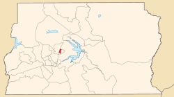
 Cruzeiro (incl. Sueoeste / Octagonal) on the map of the Federal District Cruzeiro (incl. Sueoeste / Octagonal) on the map of the Federal District
|
||
| Symbols | ||
|
||
| Basic data | ||
| Country | Brazil | |
| Federal District | Federal District | |
| Administrative region | RA XI | |
| ISO 3166-2 | BR-DF | |
| surface | 8.9 km² | |
| Residents | 63,883 | |
| density | 7,177.9 Ew. / km² | |
| Telephone code | (+55) 61 | |
| Time zone | UTC −3 | |
| Website | www.cruzeiro.df.gov.br (Brazilian Portuguese) | |
| politics | ||
| Regional administrator | Paulo Henrique Ramos Feitosa | |
| HDI | 0.928 | |
Cruzeiro , officially Portuguese Região Administrativa de Cruzeiro ( RA XI ), is an administrative region of the federal capital Brasília with 63,883 inhabitants 7 km west of the city center in the Brazilian federal district . The administrative region borders on SIA , Brasília and Sudoeste / Octogonal . The administrative region includes Cruzeiro Velho, the development of which began in 1958 and where civil servants from the old capital Rio de Janeiro settled, and Cruzeiro Novo which was built in the 1970s. In 2003 Sudoeste and Octogonal were separated as a separate administrative region Sudoeste / Octogonal.
administration
The administrator of the administrative region is Paulo Henrique Ramos Feitosa .
Web links
Commons : Cruzeiro - collection of images, videos and audio files
- Cruzeiro Administrative Region website (Portuguese)

