Paranoá
| Região Administrativa de Paranoá Paranoá |
||
|---|---|---|
|
Main street of Paranoá
|
||
|
|
||
| Coordinates | 15 ° 46 ′ S , 47 ° 47 ′ W | |
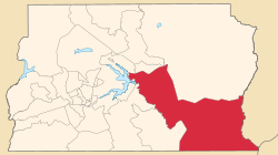
 Paranoá on the Federal District map Paranoá on the Federal District map
|
||
| Symbols | ||
|
||
| founding | December 10, 1964 | |
| Basic data | ||
| Country | Brazil | |
| Federal District | Federal District | |
| Administrative region | RA VII | |
| ISO 3166-2 | BR-DF | |
| surface | 853.3 km² | |
| Residents | 46,527 (PDAD / 2011) | |
| density | 54.5 Ew. / km² | |
| Telephone code | (+55) 61 | |
| Time zone | UTC −3 | |
| Website | www.paranoa.df.gov.br (Brazilian Portuguese) | |
| politics | ||
| Regional administrator | Waldir Soares Cordeiro (2016) | |
|
View of Brasília from Parque Vivencial of Paranoá
|
||
Paranoá , officially Portuguese Região Administrativa de Paranoá , is the administrative region RA VII with 46,527 inhabitants east of the center of Brasília in the Brazilian federal district . The administrative region borders on São Sebastião , Lago Sul , Brasília , Lago Norte , Itapoã , Sobradinho , Planaltina , Formosa (Goiás) , Cabeceira Grande ( Minas Gerais ) and Cristalina (Goias). The city goes back to the Vila Paranoá settlement for the workers at the dam of Lake Paranoá .
administration
Waldir Soares Cordeiro has been the administrator of the administrative region since 2016 .
Web links
Commons : Paranoá - collection of images, videos and audio files
- Paranoá Administrative Region website (Portuguese)
Individual evidence
- ↑ Brief profile on the website of the administrative region ( memento of the original from April 2, 2016 in the Internet Archive ) Info: The archive link has been inserted automatically and has not yet been checked. Please check the original and archive link according to the instructions and then remove this notice. , accessed on May 26, 2017 (Portuguese).


