
Taguatinga (Federal District)
| Região Administrativa de Taguatinga Taguatinga |
|||
|---|---|---|---|
 View of the center
|
|||
|
|||
| Coordinates | 15 ° 50 ′ S , 48 ° 3 ′ W | ||

|
|||
| Symbols | |||
|
|||
| founding | 5th June 1958 | ||
| Basic data | |||
| Country | Brazil | ||
| Federal District | Federal District | ||
| Administrative region | RA III | ||
| ISO 3166-2 | BR-DF | ||
| structure | 3 main sectors, 10 sub-sectors | ||
| height | 1200 m | ||
| Waters | Catchment areas: Lago Paranoá , Rio Descoberto | ||
| surface | 121.3 km² | ||
| Residents | 221,909 (2010) | ||
| density | 1,828.8 Ew. / km² | ||
| estimate | 300,000 (2015) | ||
| Post Code | 71900-100 to 72162-331 | ||
| Telephone code | (+55) 61 | ||
| Time zone | UTC −3 | ||
| Website | taguatinga.df (Brazilian Portuguese) | ||
| politics | |||
| Regional administrator | Geraldo César de Araújo (2019 - incumbent) | ||
| Culture | |||
| Patron saint | Our Lady of Perpetual Help , feast June 27th | ||
| HDI | 0.836 (high) (2010) | ||

.svg)
Taguatinga is an administrative district in the Federal District in Brazil . It is located about 20 km west of the capital Brasília .
history
Taguatinga was founded as a satellite city for Brasília on June 5, 1958 on the site of the former Fazenda Taguatinga in order to prevent immigrants from other regions from building favelas around Brasília . Initially the city was called "Vila Sarah Kubitschek ", later it was renamed "Santa Cruz de Taguatinga", of which only "Taguatinga" remains today.
administration
The administrator of the administrative region was Karolyne Guimarães dos Santos until 2019, who was replaced by the entrepreneur Geraldo César de Araújo in 2019.
Taguatinga is divided into three sectors: Taguatinga Norte, Taguatinga Centro and Taguatinga Sul. According to the 2010 census, urban and rural areas had around 222,000 inhabitants, which grew to an estimated 300,000 inhabitants in 2015.
traffic
Taguatinga is connected to the Linha Verde , German Green Line , by three metro stations of the Federal District Metro to Brasília:
- Praça do Relógio
- Taguatinga Sul
- Centro Metropolitano
The DF-085 (Estrada Parque Taguatinga - EPTG, or "Linha Verde"), DF-095 (Estrada Parque Ceilândia - EPCL) and the DF-075 (Estrada Parque Núcleo Bandeirante - EPNB) run within the federal district.
The BR-070 federal road connects Taguatinga with the Goian cities of Águas Lindas de Goiás and Pirenópolis .
education

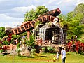
The Praça do Relógio (Clock Square) in the city center
Taguaparque

Córrego Cortado, source stream of Lago do Cortado in the Parque Ecológico do Cortado


Sports
The place is the seat of two football clubs, the Taguatinga Esporte Clube founded in 1964 and the Brasiliense Futebol Clube de Taguatinga founded in 2000 . The home stadium for both is the Estádio Elmo Serejo Faria , or Serejão or Boca do Jacaré for short .
sons and daughters of the town
- Joaquim Cruz (* 1963), middle distance runner
- Hugo Parisi (* 1984), water diver
literature
- Ronaldo Alves Mousinho: Taguatinga. História e cultura . Edições Academia Taguatinguense de Letras, Taguatinga DF 2005, ISBN 85-99109-01-4 .
- José da Silva Brandão: Taguatinga. Ensaio histórico e cultural, 1752–1958 . Edições Academia Taguatinguense de Letras, Brasília 2006, ISBN 85-7238-218-6 .
Web links
- Taguatinga Regional Administration website (Brazilian Portuguese)
- Federal District Government website (Brazilian Portuguese)
Individual evidence
- ↑ Códigos Postais de Taguatinga. In: brasilao.com. Brasilão, Retrieved October 20, 2019 (Brazilian Portuguese).
- ↑ a b Perfil do administrador ( Memento of October 20, 2019 in the Internet Archive ) Administração Regional de Taguatinga, accessed on October 20, 2019 (Brazilian Portuguese).
- ↑ Atlas do Desenvolvimento Humano no Brasil , database (Brazilian Portuguese)
- ↑ Perfil da administradora ( Memento of March 27, 2019 in the Internet Archive ) Administração Regional de Taguatinga, accessed on October 20, 2019 (Brazilian Portuguese).
Plano Piloto | Gama | Taguatinga | Brazlândia | Sobradinho | Planaltina | Paranoá | Núcleo Bandeirante | Ceilândia | Guará | Cruzeiro | Samambaia | Santa Maria | São Sebastião | Recanto das Emas | Lago Sul | Riacho Fundo | Lago Norte | Candangolândia | Águas Claras | Riacho Fundo II | Sudoeste / Octogonal | Varjão | Park Way | SCIA | Sobradinho II | Jardim Botânico | Itapoã | SIA | Vicente Pires | Fercal