
Cwm Ivy Marsh
.jpg)
The Cwm Ivy Marsh ( ˈkum aivi mɑːʃ ) is a salt marsh that was renatured in the 2010s in the northwest of the Gower Peninsula in South Wales . The protected area was separated from the sea by a dam for several centuries and was used as pastureland . In the early 2010s, the owner, the National Trust , decided to give the area back to nature, especially against the backdrop of rising sea levels and threats to similar ecosystemsin the neighborhood. The renaturation began in 2013/2014 with the tolerated breakage of the dam and within a few months created the basis for a salt marsh biotope .
geography
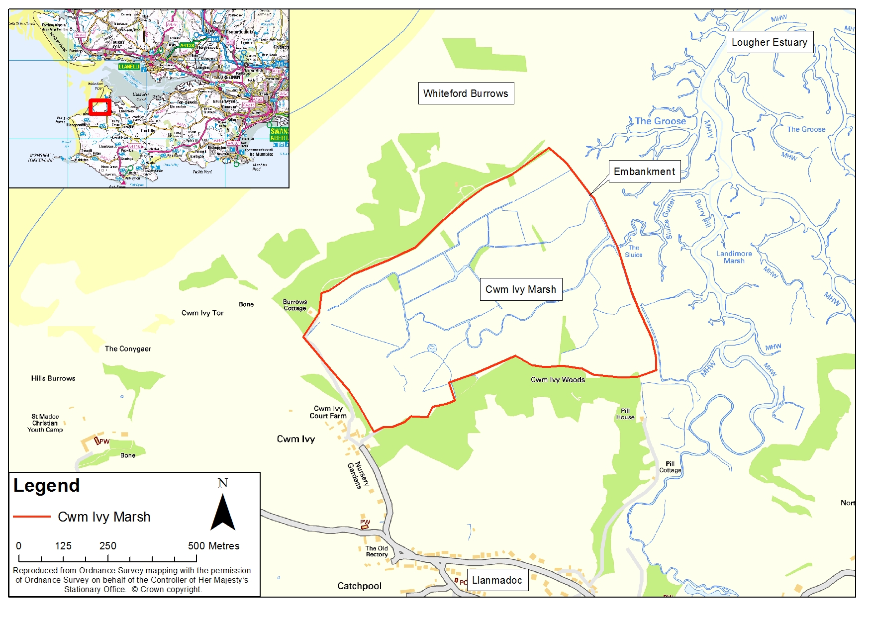
The Cwm Ivy Marsh is a piece of land that lies on the northwest coast of the Gower Peninsula near Swansea in South Wales . Not far east of today's salt marsh area is the natural salt marsh Llanrhidian Marsh . The Cwm Ivy Marsh itself borders to the east on an area called The Groose , which belongs to the estuary of the River Loughor . There is also a march there called Landimore Marsh , which is directly adjacent to the Cwm Ivy Marsh. To the south, the wet meadow borders a wooded area called Cwm Ivy Woods . The eponymous hamlet of Cwm Ivy is located on the southwest corner of the Cwm Ivy Marsh, and on the northeast corner is Burrows Cottage , which is owned by the National Trust . Not far north of the Cwm Ivy Marsh is the wide sandy beach Whiteford Sands . With the Cwm Ivy Woods , this sandy beach, the Cwm Ivy Marsh as a meadow habitat and a rock formation a little further away called the Cwm Ivy Tor , the north-western tip of Gower encompasses a wide variety of coastal biotopes, which makes it almost unique. The Wales Coast Path runs along the edge of the wet meadow . The Cwm Ivy Marsh covers a good 39 acres .
story

Today's Cwm Ivy Marsh was formerly part of the estuary of the River Loughor and formed a bay-like area that was flooded or dry depending on the tide. As early as the late Middle Ages and early modern times , the drainage of the area began in order to gain land. This process was finalized in the 17th century with the construction of a dam, which finally left the area of today's Cwm Ivy Marsh dry. The Cwm Ivy Marsh was henceforth used as pastureland , especially for sheep . In the decades and centuries that followed, the dam was regularly expanded, upgraded, and repaired to prevent seawater from entering the Cwm Ivy Marsh. Nevertheless, the area developed into a wet meadow, although primarily fresh water contributed to this development. For drainage was towards the sea, a contactor built that could be flow out when needed at low tide fresh water into the Wadden ( location ).
From the mid-2000s, government organizations looked for areas that could possibly be renatured or redesigned as salt marshes . The main reason was the rising sea level due to climate change . With an increase of around one meter, various salt marsh biotopes in the Loughor estuary as well as in the more defined Carmarthen Bay are likely to disappear. This would also destroy the unique ecosystems there. The nearby Llanrhidian Marsh is also in danger in the long term. In order to be able to compensate for a possible loss of this biotope, regional environmental authorities looked around for replacement areas. This replacement area was found with the Cwm Ivy Marsh, which was favored by the fact that the land was already owned by the National Trust . The final decision for the Cwm Ivy Marsh was made in 2012. However, the marsh was still protected by its dam. According to the National Trust's plan, if the dam breaks, the Cwm Ivy Marsh will be flooded at high tide . As a result, it should slowly develop into a salt marsh, which would create an additional salt marsh biotope in the area. Such a new biotope would also function as another good carbon dioxide store.
At this point the authorities were lucky. Over time, the dam had gradually become a little less efficient due to rising sea levels. In November 2013 there was constant heavy rain in the region and high water levels within the march, which could no longer be drained by the contactor. The excessively high water pressure caused a hole to form near the gate in the area of the dam close to the ground, which was enlarged by further winter storms. As a result, salt water soon flowed onto the wet meadow, albeit to a very limited extent. Repairing the dam would have been possible, but in line with their strategy, the National Trust decided not to repair the dam anymore and instead let it break naturally. The renaturation of the Cwm Ivy Marsh, which was to be reintegrated into the natural ecosystem of the estuary, was also started passively .
There were different plans for the exact implementation of the renaturation. The existing leak in the dam was the starting point, but there were suggestions, for example, to artificially widen the leak or to bring about further dam breaks. For an interim period, however, a decision was made against these plans: the leak should break the dam without any further artificial influences, and the renaturation should also largely take place without human intervention. According to this plan, additional dam breaks are desired, but are also not actively brought about. This strategy was later officially confirmed after consultations with the City and County of Swansea . The government organization Natural Resources Wales was in charge of the project and the National Trust coordinated the undertaking. The undertaking in itself was the first of its kind in Wales and, right from the start, aimed to serve as a case study and model for future projects.
.jpg)
During a summer storm in August 2014, the dam in the area of the Schütz broke for good. This marked the beginning of the actual transformation of the area, which was not influenced by the National Trust . Rather, the Cwm Ivy Marsh became part of the Shifting Shores program of the National Trust, with which the renaturation of coastal areas is supported and promoted. In fact, the area is now inundated at high tide and developed into a salt marsh with a corresponding ecosystem in the course of the following months . In addition, small remnants of the freshwater wet meadows remained. The dam itself did not break in other places, but the existing dam breach expanded to several meters in length by 2015. The dam breach also had an impact on the Wales Coast Path . This had previously led over the dam and further along the southern and western borders of the Cwm Ivy Marsh, but this route was no longer accessible due to the dam breach. A replacement route was created along the northern border of what is now the salt marsh. Two bird watching towers were built to observe the new ecosystem. During the renaturation process, various stakeholders were heard and public presentations and discussions were held. Studies have also been carried out on the likely effects. Nevertheless, the project met with some criticism from the population, in particular because of the destruction of the former cultural landscape and the disruption of the Wales Coast Path .
The Cwm Ivy Marsh is part of the Area of Outstanding Natural Beauty of the Gower Peninsula. It is also part of the Gower Heritage Coast and is a Landscape of Outstanding Historic Interest . It forms its own landscape character area . It is also part of the Site of Special Scientific Interest Cwm Ivy Marsh and Tor .
Flora and fauna
Before the area was flooded, the Cwm Ivy Marsh consisted of extensive grassland with scattered trees. The grass in particular died within a few days after the flooding. Over the following months, the trees, most of which were already dead wood in the spring of 2015, also died . These trees were mostly black pines and willows . Four months after the dam broke, the Cwm Ivy Marsh was gradually overgrown by typical salt marsh plants, which were able to benefit from the nutritious, washed-up mud with its microfauna . These plants that belonged Genuine spoon herb , several species of the genus of samphire , the beach-Sode , the beach Thrift , spergularia and species of the genus Derbesia , but also the Common Darmtang the beach aster , the beach trident , the beach Lilac and the species Sesuvium portulacastrum . A larger colony of reeds developed in the southern part of the Cwm Ivy Marsh . In total, more than 150 plant species settled after the renaturation. The flora transformation process was largely completed around June 2015. Since then, the salt marsh flora has provided a reservoir for a wide variety of insect species .
Various marine animals come along with the floods and look for food there. Examples of this are crabs and the great mullet . The same applies, for example, to the nudibranch , the mud shrimp and at least one species of the genus Nereids . In addition, the very rare and very small narrow diaper snail also settled . The bird fauna is also represented on the Cwm Ivy Marsh after the renaturation: Some songbirds and waterfowl have settled there , for example lapwing , heron , kingfishers , woodpeckers , swallows , skylarks and curlews . In addition, reptiles such as grass snakes , blindworms and forest lizards , amphibians such as the common toad , mammals such as badgers , red foxes and otters and dragonflies became indigenous. In addition, there have been sightings of a polecat , hen harriers and ospreys . Attempts have been made to actively establish the latter since 2015, in particular by means of nesting facilities provided. It is hoped that further animal species will settle here, including bitterns , bearded tits and voles . In the long term, the Cwm Ivy Marsh is intended to serve various animal species as an “important new feeding and resting place” and provide a shelter for the “special” ecosystem of Carmarthen Bay .
Web links
Individual evidence
- ↑ a b c d e f g h i j k l m n o p q r Cwm Ivy: Where the sea comes in. National Trust , accessed on September 1, 2021 (English).
- ↑ a b c Cwm Ivy Habitat Creation Project - Coastal Embankment Access. (PDF) Natural Resources Wales, accessed September 2, 2021 (Welsh, English).
- ^ Map of the Cwm Ivy Marsh. Natural Resources Wales, accessed September 2, 2021 .
- ↑ a b c d e Prosiect Creu Cynefin Cwm Ivy / Cwm Ivy Habitat Creation Project. (PDF) Natural Resources Wales, accessed September 3, 2021 (Welsh, English).
- ↑ a b c d e Judith Doyle: Cwm Ivy . In: The Archaelogist . No. 108 , 2019, p. 10 f .
- ↑ a b c d e f g Steven Morris: 'It wasn't pretty at first': the Welsh wildlife haven born out of disaster. The Guardian , May 10, 2021, accessed September 3, 2021 .
- ↑ a b c d e f Cwm Ivy Marsh Habitat Creation Project. Natural Resources Wales, accessed September 2, 2021 .
- ↑ Cwm Ivy Habitat Creation Project Project Factsheet. (PDF) Natural Resources Wales, accessed September 2, 2021 (English, Welsh).
- ^ Cwm Ivy Marsh, Gower. Archaelogy Wales, accessed September 3, 2021 .
-
^ Neil Wilson, Bob Denley, Guto ap Gwent: Letters: Welsh salt marsh blocks much-prized coastal path. The Guardian , July 1, 2021, accessed September 3, 2021 . Richard Youle: The stunning centuries-old marshland walk in Gower no-one can use. Wales Online, February 7, 2018, accessed September 3, 2021 .
- ↑ Gower Nature Reserves and SSSIs. Gower Holidays, October 6, 2017, accessed September 3, 2021 .
- ↑ Explore Cwm Ivy. National Trust , accessed September 3, 2021 .
Coordinates: 51 ° 37'26 " N , 4 ° 15'7" W.