Dellwig (Fröndenberg)
|
Dellwig
City of Fröndenberg / Ruhr
Coordinates: 51 ° 28 ′ 44 " N , 7 ° 41 ′ 29" E
|
|
|---|---|
| Area : | 2.64 km² |
| Residents : | 1599 (Dec. 31, 2013) |
| Population density : | 606 inhabitants / km² |
| Incorporation : | August 1, 1964 |
| Incorporated into: | Langschede |
| Postal code : | 58730 |
| Area code : | 02378 |
|
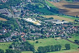
View of the district of Dellwig
|
|
Dellwig is a district of the Westphalian town of Fröndenberg / Ruhr , district of Unna , with around 1,600 inhabitants.
geography
location
Dellwig is in the west of the city. The Ruhr forms the southern border of the place.
Neighboring communities
In 1963, Dellwig bordered in a clockwise direction in the west on the municipalities of Altendorf , Billmerich , Strickherdicke and Langschede (all in the Unna district ) and Halingen and Hennen (both in the Iserlohn district at that time ).
history
Dellwig part in the establishment of offices in the Prussian province of Westphalia to the Office Fröndenberg in district Hamm . On the occasion of the city of Hamm on April 1, 1901, the district became the district of Hamm. After an area expansion in 1929, this was renamed the Unna district in October 1930 . On August 1, 1964, Dellwig was incorporated into the municipality of Langschede together with Ardey . On January 1st, 1968 Altendorf, Bausenhagen, Frohnhausen, Frömern, Langschede, Neimen, Ostbüren, Stentrop, Strickherdicke and Warmen were incorporated into Fröndenberg.
Population development
| year | Residents |
|---|---|
| 1849 | 353 |
| 1910 | 586 |
| 1931 | 670 |
| 1956 | 1048 |
| 1961 | 1337 |
| 1987 | 1453 |
| 2013 | 1599 |
traffic
The state road L 673 connects Dellwig in the west with Altendorf, Geisecke , Schwerte , Westhofen and Garenfeld and in the east with Langschede, Fröndenberg / Ruhr and Wickede (Ruhr) .
Sons and daughters (selection)
- Wilhelm von Bodelschwingh (1869–1921), pastor
Web links
Individual evidence
- ↑ Stephanie Reekers: The regional development of the districts and communities of Westphalia 1817-1967 . Aschendorff, Münster Westfalen 1977, ISBN 3-402-05875-8 , p. 196, 214, 256, 317 .
- ↑ Martin Bünermann: The communities of the first reorganization program in North Rhine-Westphalia . Deutscher Gemeindeverlag, Cologne 1970, p. 63 .
- ^ MF Essellen: Description and brief history of the Hamm district and the individual localities in the same . Verlag Reimann GmbH & Co, Hamm 1985, ISBN 3-923846-07-X , p. 193 .
- ↑ www.gemeindeververzeichnis.de: Population figures 1910
- ↑ Handbook of the offices and rural communities in the Rhine province and in the province of Westphalia , Prussian Landgemeindetag West, Berlin 1931.
- ^ Otto Lucas: Kreis-Atlas Unna . Unna / Münster 1957.
- ↑ Martin Bünermann, Heinz Köstering: The communities and districts after the municipal territorial reform in North Rhine-Westphalia . Deutscher Gemeindeverlag, Cologne 1975, ISBN 3-555-30092-X , p. 175 .
- ^ State Office for Data Processing and Statistics (ed.): Population and private households as well as buildings and apartments. Selected results for parts of the community. Arnsberg administrative district . Düsseldorf 1990, p. 272 .
- ^ Inhabitants in the districts of the towns and municipalities of the Unna district
