Djoma
|
Djoma Дёма, Дим (Dim) |
||
|
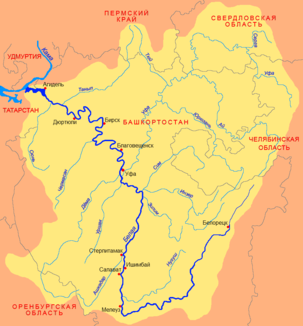
Location of the Djoma (Дёма) in the catchment area of the Belaya |
||
| Data | ||
| Water code | RU : 10010201312111100024137 | |
| location | Bashkortostan , Orenburg Oblast ( Russia ) | |
| River system | Volga | |
| Drain over | Belaya → Kama → Volga → Caspian Sea | |
| source |
Obschtschi Syrt northwest of Meleus 53 ° 10 ′ 43 ″ N , 55 ° 2 ′ 54 ″ E |
|
| Source height | approx. 390 m | |
| muzzle | in the Belaja in Ufa coordinates: 54 ° 42 ′ 50 ″ N , 55 ° 54 ′ 48 ″ E 54 ° 42 ′ 50 ″ N , 55 ° 54 ′ 48 ″ E |
|
| Mouth height | 83 m | |
| Height difference | approx. 307 m | |
| Bottom slope | approx. 0.57 ‰ | |
| length | 535 km | |
| Catchment area | 12,800 km² | |
| Outflow at the Ufa (city) gauge at the mouth |
MQ |
35 m³ / s |
| Left tributaries | Sadak, Meneus, Kursak | |
| Right tributaries | Tjater, Ujasy | |
| Big cities | Ufa | |
| Medium-sized cities | Dawlekanowo , Tschischmy | |
| Communities | Rajewski | |
|
The Djoma at Botschkarevka |
||
The Djoma ( Russian Дёма ; Bashkir Дим / Dim ) is a 535 km long left tributary of the Belaja west of the Urals in Russia .
course
The Djoma rises at a height of about 390 m at the northwest end of the Obschtschi Syrt ridge , at its transition to the Bugulma-Belebeier ridge , a good 60 kilometers northwest of the town of Meleus in the southwest of Bashkortostan . It initially flows in a south-westerly direction, reaches Orenburg Oblast and turns in a wide valley to the north-west. After several dozen kilometers, the course of the river takes a north-easterly to north-westerly direction, reaches Bashkortostan again and cuts through the ridge again. Then the river valley widens again. From the middle reaches the river meanders strongly and has left a large number of oxbow lakes.
The Djoma flows into the Kama tributary Belaja (Agidel) on the south-western edge of the republic's capital Ufa . The formerly independent district, a few kilometers away to the left of Belaja and Djoma, bears the name Djoma after the river. Until the construction of the Samara - Ufa - Slatoust - Chelyabinsk railway at the end of the 19th century, which soon became part of the original route and today's southern route of the Trans-Siberian Railway , the Djoma flowed several kilometers below. In order to only have to build a railway bridge over the Belaja, an artificial river section about one kilometer long was created, through which the Djoma flows above the bridge since then.
The Djoma does not have any major tributaries; the most important are Sadak, Meneus and Kursak from the left and Tjater and Ujasy from the right. The large village of Rajewski , the town of Dawlekanowo and, a few kilometers away, the urban-type Chishmy settlement are located on the river next to Ufa .
Hydrography
The catchment area of the Djoma covers 12,800 km². At the lower reaches it is about 70 meters wide and about two meters deep; the flow velocity there is 0.5 m / s. The mean flow rate at the mouth is 35 m³ / s.
Economy and Infrastructure
The Djoma is not navigable. It flows through predominantly agricultural areas.
In the area of Orenburg Oblast, the 1R239 trunk road follows the left side of the river , which connects Kazan to Orenburg via Tschistopol and Bugulma . From the middle course above Rajewski, the Samara - Ufa - Tscheljabinsk railway follows the course of the Djoma, on short sections also directly on the river. The Ufa - Orenburg railway line and the southern bypass around Ufa cross the river near Ufa along the M5 trunk road .

