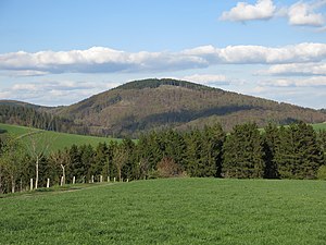
Dommel (mountain)
| Dommel | ||
|---|---|---|
| height | 738 m above sea level NHN | |
| location | at Ottlar ; District of Waldeck-Frankenberg , North Hesse ( Germany ) | |
| Mountains | Upland ( Rothaar Mountains ) | |
| Dominance | 3.8 km → Sähre | |
| Notch height | 143 m ↓ 1.13 km southeast of the summit; to the Emmet | |
| Coordinates | 51 ° 19 '54 " N , 8 ° 40' 11" E | |
|
|
||
| particularities | Lookout tower Dommelturm | |
The Dommel near Ottlar in the north Hessian district of Waldeck-Frankenberg is 738 m above sea level. NHN high mountain of the Upland in the Rothaar Mountains .
geography
location
The Dommel is located in the Upland, the northeast outlet of the Rothaar Mountains, in the Diemelsee Nature Park between Willingen and the Diemelsee reservoir . Its summit rises 2.8 km north-northeast of Rattlar and 2 km (as the crow flies ) west of Ottlar . The mountain is surrounded in the east, south and west by the Dommelbach , which flows not far north-northwest into the Itter , which feeds the western arm of the Diemelsee. A little further east flows through Ottlar the Holzbach, which runs to the northeast and flows into the eastern arm of the same reservoir.
Natural allocation
The Dommel belongs to the natural spatial main unit group Süderbergland (No. 33), in the main unit Rothaargebirge (with Hochsauerland ) (333) and in the subunit Hochsauerländer Schluchtgebirge (333.8) to the natural area Schellhorn and Treiswald (333.82). Its south-eastern foothills Brenschelt (637.3 m; ESE) and Sinzelieth (638.6 m, SSE) beyond the Dommelhof are already part of the Inner Upland (333.90) natural area in the sub-unit Upland (333.9 ). Between deb veiden mentioned peaks located at about 595 m the nick of Dommel to slightly higher Emmet .
Dommelturm
The Dommelturm observation tower is on the summit of the Dommel . A simple wooden scaffolding on the hilltop is documented as early as 1909. According to residents' reports, a successor tower stood until around 1945; it was probably used as a fire watch against air attacks. The tower, which is probably already the third, was built entirely of wood as a lookout tower in 1973 on four concrete foundations (for the wooden posts). Because of its dilapidation, it had to be blocked and demolished in 2006. In September 2007 the new cathedral tower was built as a 14 m high wooden structure with steel stairs.
From the observation deck of the tower an often impressive all-round visibility allows not only to near vision objectives of the Uplands and Diemelsee nature reserve - such as the Ettelsberg with Hochheideturm : To the northwest is Upper Arnsberg Forest to recognize the north of the Teutoburg Forest , in the north-northeast, the Eggegebirge , in In the northeast the Lipper Bergland and the Solling , in the east-northeast the Reinhardswald and the Harz Mountains behind it , in the east the Habichtswälder Bergland and the Hohe Meißner beyond , in the east-southeast the Thuringian Forest , in the southeast the Kellerwald and - in each case behind it - the Knüllgebirge and the Rhön and the Vogelsberg in the south-southeast .
Web links
- 360-degree panorama from the Dommelturm (labeling of visual targets can be activated), on panorama-photo.net
References and comments
- ↑ a b c Map services of the Federal Agency for Nature Conservation ( information )
- ↑ To the Dreiskopf it is only a little further with 3.9 km.
- ↑ Martin Bürgener: Geographical Land Survey: The natural spatial units on sheet 111 Arolsen. Federal Institute for Regional Studies, Bad Godesberg 1963. → Online map (PDF; 4.1 MB)
- ↑ old postcards, school and village chronicle Ottlar
- ^ Dommelturm in: Viewpoints , on naturpark-diemelsee.de


