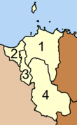
Don Sak district
|
Don Sak ดอนสัก |
|
|---|---|
| Province: | Surat Thani |
| Surface: | 460.9 km² |
| Residents: | 36,594 (2012) |
| Population density : | 77.0 U / km² |
| ZIP : | 84220, 84160, 84340 |
| Geocode : | 8403 |
| map | |

|
|
Amphoe Don Sak ( Thai อำเภอ ดอนสัก ) is a district ( amphoe - administrative district) in the east of Surat Thani Province . The Surat Thani Province is located in the southern region of Thailand .
geography
The ferry port to the tourist island of Koh Samui is in this district.
The neighboring Amphoe are clockwise from the east: the two Amphoe Khanom and Sichon in the province of Nakhon Si Thammarat and Amphoe Kanchanadit in Surat Thani. In the north lies the Gulf of Thailand with islands that belong to the Ko Samui district .
history
The area of today's Don Sak was originally part of the Amphoe Sichon in the province of Nakhon Si Thammarat. In 1929 the two districts Don Sak and Chaiyakhram were assigned to the Amphoe Kanchanadit. On March 24, 1969, the small district ( King Amphoe ) Don Sak was created by separating the two tambon Don Sak and Chon La Kram from the district Amphoe Kanchanadit . The residents of Tambon Chai Ya Kram then asked to be admitted to the new district, which was granted on September 1, 1969. On November 16, 1971, Don Sak received full amphoe status. The fourth Tambon Pak Prak was created on July 14, 1978 from parts of the Tambon Don Sak and Chai Ya Kram.
Attractions
- Wat Khao Suwan Pradit (Thai: วัด เขา สุวรรณ ประดิษฐ์ ) is a Buddhist temple ( Wat ) , which is located on a hill about 1 km from Don Sak. It was founded in 1982 by Luang Pho Choi, a highly revered monk in southern Thailand. At the top of the hill is a 45 m high chedi , which is said to contain a relic of the Buddha from Wat Phra Kiat ( Amphoe Hot , Chiang Mai Province ). The platform around the chedi offers an excellent view of the city and the Gulf of Thailand.
administration
Provincial Administration
The Amphoe Don Sak is divided into four subdistricts ( tambon ) , which in turn have a total of 37 communities ( muban ) .
|
Local administration
Don Sak ( เทศบาล ตำบล ดอนสัก ) is a small town ( Thesaban Tambon ) in the district, it consists of parts of the Tambon Don Sak.
There are also four "Tambon Administrative Organizations " ( องค์การ บริหาร ส่วน ตำบล - Tambon Administrative Organizations, TAO) for the Tambon or the parts of Tambon in the district that do not belong to any city.
Individual evidence
- ↑ แจ้ง ความ กระทรวง มหาดไทย เรื่อง โอน ตำบล . In: Royal Gazette . 46, No. 0 ง , April 14, 1929, p. 149.
- ↑ ประกาศ กระทรวง มหาดไทย เรื่อง แบ่ง ท้องที่ ตั้ง เป็น กิ่ง อำเภอ . In: Royal Gazette . 86, No. 27 ง , April 1, 1969, p. 1206.
- ↑ ประกาศ กระทรวง มหาดไทย เรื่อง เปลี่ยนแปลง เขต กิ่ง อำเภอ ดอนสัก อำเภอ กาญจน ดิ ษ ฐ จังหวัด สุราษฎร์ธานี . In: Royal Gazette . 86, No. 80 ง , September 16, 1969, p. 2851.
- ↑ พระราชกฤษฎีกา ตั้ง อำเภอ ปลาปาก อำเภอ เชียงกลาง อำเภอ ปากชม อำเภอ บ้านม่วง อำเภอ พังโคน อำเภอ ดอนสัก อำเภอ พนม อำเภอ เวียงสระ อำเภอ สังคม และ อำเภอ หัวตะพาน พ.ศ. ๒๕๑๔ . In: Royal Gazette . 88, No. 123 ก , November 16, 1971, pp. 745-748.
- ↑ ประกาศ กระทรวง มหาดไทย เรื่อง ตั้ง และ เปลี่ยนแปลง เขต ตำบล ใน ท้องที่ อำเภอ เวียงสระ และ อำเภอ ดอนสัก จังหวัด สุราษฎร์ธานี . In: Royal Gazette . 95, No. 76 ง , August 1, 1978, pp. 2456-2559.
- ↑ Population statistics 2012 . Department of Provincial Administration. Retrieved July 13, 2014.
Web links
Coordinates: 9 ° 19 ' N , 99 ° 41' E


