Dreikretscham
|
Dreikretscham
Haslow Municipality of Göda
Coordinates: 51 ° 13 ′ 16 ″ N , 14 ° 18 ′ 48 ″ E
|
|
|---|---|
| Height : | 164 m above sea level NHN |
| Residents : | 72 (December 31, 2016) |
| Incorporation : | April 1, 1936 |
| Incorporated into: | Storcha |
| Postal code : | 02633 |
| Area code : | 035937 |
|
The eastern district with the stone cross
|
|
Dreikretscham , Sorbian , is a village in the East Saxon district of Bautzen , which has belonged to the municipality of Göda since 1994 . It is part of the Catholic core of the Sorbian settlement area in Upper Lusatia .
geography
Dreikretscham is one of the northernmost districts of the municipality of Göda and is located on both sides of the black water, which has been straightened in this section, at 164 m above sea level. NHN . The surrounding valley slopes rise about forty meters above the valley floor, where Dreikretscham is located. The neighboring towns are Weidlitz (municipality of Neschwitz ) in the north, Sollschwitz in the south and Storcha in the west. The place is located about nine kilometers northwest of the district town of Bautzen and five kilometers north of the Göda community center. The area is used intensively for agriculture and is hardly forested.
After the settlement, Dreikretscham is a conglomerate of an alley village and three farmer hamlets that mark the location of the three old inns.
history
The place is first recorded in the 14th century as Dryekreczim . In the 15th century names like Dreyen Kreczmarn (1460; Kretschmar = "innkeeper") followed. In 1617 the Sorbian name "Haßlow" is also mentioned as a German form. At that time the place belonged to the manor in neighboring Sollschwitz. In the 18th century the basic division was more complicated: the manors Bolbritz , Loga and Weidlitz shared the manor . Parts of the place also belonged to the city of Bautzen and the Landvogtei. Several granite quarries were in operation around Dreikretscham in the 18th and 19th centuries.
In 1910 the first bridge over the Schwarzwasser was opened. Until then, vehicles had to use the ford . Until 1936 Dreikretscham formed an independent rural community. Then it was incorporated into Storcha. From 1962 to 1994, the two places belonged to the municipality of Prischwitz before they were incorporated into Göda.
The place is traditionally part of the Bautzen district . An exception was the period between July 25 and December 4, 1952, when Dreikretscham was briefly reclassified to the Kamenz district.
Place name
The German place name comes from the word " Kretscham " for "restaurant" (Sorb. Korčma ) and describes the fact that here - at the ford of a branch of the Via Regia through the Schwarzwasser - three innkeepers were waiting for the traveler. The Sorbian name is probably based on the German word " Hasel ". Today, the name "Haslow" for three squares is noticeably widespread among the non-Sorbian population in the area.
population
For his statistics on the Sorbian population in Upper Lusatia, Arnošt Muka determined a population of 72 inhabitants for the place in the 1880s; 71 of them were Sorbs. In 1956 Ernst Tschernik counted a Sorbian-speaking population of 70.9% in the municipality of Storcha, to which Dreikretscham now belonged. Sorbian is spoken in the village to this day.
In 1910 Dreikretscham already had 95 inhabitants, although the number fell slightly in the following years.
religion
Dreikretscham has always been part of the Catholic part of Upper Lusatia. The last figures on the denomination of the inhabitants are from 1925. At that time, 78 out of 87 inhabitants were Catholics (90%). The Catholic portion was parish to Crostwitz until the Herz-Jesu-Kirche was built in Storcha in 1887 ; the Protestant portion since the 16th century first to Göda, then since 1809 to Neschwitz .
Economy and Infrastructure
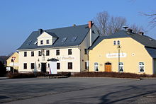
Of the three former "Kretschamen", only one still exists today, the Gasthof Dreikretscham with its dance hall, which is often used for events.
The place is at the intersection of the state road 107 (Göda-Radibor) with the county road to Crostwitz. The next junction of the Autobahn 4 ( Salzenforst ) is five kilometers away.
Attractions
The fisherman's mill was first mentioned as a three-sided farm in 1760. The historic mill building was extended by two floors in 1922. The mill was operated with water power until 1974 when it was converted to electricity. In addition to the actual mill, the listed ensemble also includes a residential building and several farm buildings.
On the east side of the Schwarzwasser Bridge is a 1.50 meter high atonement cross , which originally stood directly at the ford and was implemented in the 1930s. According to legend, it is reminiscent of a French soldier.
On their annual route from Storcha to Radibor and in the opposite direction, the Osterreiter traverse Dreikretscham.
literature
- Cornelius Gurlitt : Dreikretscham. In: Descriptive representation of the older architectural and art monuments of the Kingdom of Saxony. 31. Booklet: Bautzen Official Authority (Part I) . CC Meinhold, Dresden 1908, p. 53.
Web links
- Dreikretscham in the Digital Historical Directory of Saxony
Individual evidence
- ^ Ernst Eichler / Hans Walther : Oberlausitzer Ortnamesbuch. Akademie-Verlag, Berlin 1975
- ↑ Ernst Tschernik: The development of the Sorbian population . Akademie-Verlag, Berlin 1954, p. 52 .
- ^ Ludwig Elle: Language policy in the Lausitz . Domowina-Verlag, Bautzen 1995, p. 246 .
- ^ Free State of Saxony , State Ministry of the Interior : Particularly endangered cultural monuments in the Free State of Saxony: town houses, farmhouses , series of publications for building culture, architecture, monument preservation, series B, Bulletin 2, Dresden 1995, p. 117.


