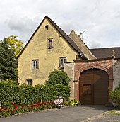
Dromersheim
|
Dromersheim
City of Bingen on the Rhine
|
||
|---|---|---|
| Coordinates: 49 ° 55 ′ 28 " N , 7 ° 57 ′ 45" E | ||
| Height : | 147 m above sea level NHN | |
| Residents : | 1531 (March 1, 2011) | |
| Incorporation : | April 22, 1972 | |
| Postal code : | 55411 | |
| Area code : | 06725 | |
|
Location of Dromersheim in Rhineland-Palatinate |
||

Dromersheim is a district of Bingen am Rhein in Rhineland-Palatinate .
history
The first documentary mention was made by Edling Eggiolt von Worms on June 15, 754 as Truhtmaresheim .
On February 11, 1830, ice wine was first harvested in Germany in the Dromersheim vineyards .
The previously independent municipality of Dromersheim was incorporated into Bingen on April 22, 1972 with a population of 1,221 at that time.
coat of arms
The coat of arms of the former municipality of Dromersheim is quartered. In fields one and four each a silver Mainz wheel on a red background. In the second field on a blue background a golden crown, framed by seven silver stars and a silver crescent moon (reference to the Madonna known as the “beautiful Dromersheimerin”). In the third field, also on a blue background, two crossed golden keys. The keys symbolize Saint Peter, one of the church patrons of the village.
Culture and sights
In the list of cultural monuments in Bingen am Rhein , 13 individual monuments and one monument zone are listed for Dromersheim .
music
- Catholic church music Bingen-Dromersheim
- Männgergesangsverein Bingen-Dromersheim 1872
Buildings
- Dromersheim parish church
Sports
- Gymnastics and sports club 1899 Bingen-Dromersheim
Other clubs
- Farmers' Association Bingen-Dromersheim
- Catholic young community Dromersheim
- Rural women's association Bingen-Dromersheim
- Local association Bingen-Dromersheim e. V.
- Carneval Club Ledekepp e.V. V.
Economy and Infrastructure
traffic
Dromersheim is at the intersection of Landstrasse 414 and Bundesstrasse 41 , motorways 60 and 61 are a maximum of 10 km away.
The district is connected to Bingen by city buses every half hour. There is a bus connection to Bad Kreuznach three times a day . The next train stations are on the left bank of the Rhine in Bingen, as well as the Rheinhessenbahn and Nahetalbahn in Gensingen - Horrweiler , Ockenheim or Gau-Algesheim .
education
There is a primary school in the village itself. The Realschule Plus is in the Büdesheim district. Secondary schools ( Stefan-George-Gymnasium and Hildegardisschule) are in Bingen and in Büdesheim the Rochus-Realschule. There is a vocational school (secondary level I and technical diploma) in Bingen. There is an integrated comprehensive school in Ingelheim am Rhein with the option of secondary school leaving certificate or Abitur .
Personalities
Sons and daughters of the district
- Richard Faust (1927–2000), director of the Frankfurt Zoological Garden
- Peter Tischleder (1891–1947), Roman Catholic priest and professor of theology in Münster and Mainz
- Saskia Tittgen, Rheinhessische Weinprinzessin 2008/2009
Personalities who have worked on site
- Gottfried Mascop (* before 1550; † after 1603), German cartographer of the second half of the 16th century, district plans
- Burkard Zamels (* around 1690; † 1757), sculptor, crucifixion group, around 1750
Web links
- Dromersheim - A portrait of Bernd Schwab on Hierzuland SWR TV from 2004
- The beautiful Dromersheimer parish of St. Peter and Paul, Dromersheim
- Historical information about Dromersheim at regionalgeschichte.net
Individual evidence
- ↑ Official municipality directory 2006 ( Memento from December 22, 2017 in the Internet Archive ) (= State Statistical Office Rhineland-Palatinate [Hrsg.]: Statistical volumes . Volume 393 ). Bad Ems March 2006, p. 171 (PDF; 2.6 MB). Info: An up-to-date directory ( 2016 ) is available, but in the section "Territorial changes - Territorial administrative reform" it does not give any population figures.


