
Leonberg motorway triangle
| Leonberg motorway triangle | |
|---|---|
|
|
|
| map | |
 |
|
| location | |
| Country: | Germany |
| State : | Baden-Württemberg |
| Coordinates: | 48 ° 46 '54 " N , 9 ° 0' 43" E |
| Height: | 370 m above sea level NN |
| Basic data | |
| Design type: | Complete triangle (Full-Y) |
| Bridges: | 4 (motorway) / 5 (other) |
| Construction year: | 1938 |
| Last modification: | 1995-1999 |
,_Richtungstafel.JPG) |
|
| The A 8 at the Leonberg triangle towards Stuttgart | |

The Leonberg motorway triangle (abbreviation: AD Leonberg ; short form: Leonberg triangle ; formerly the Stuttgart motorway triangle ) is a motorway triangle in Baden-Württemberg in the Stuttgart metropolitan region . It connects the federal autobahn 8 ( Saarland - Stuttgart - Munich - Salzburg ) ( Europastraße 52 ) with the federal autobahn 81 ( Würzburg - Stuttgart - Singen (Hohentwiel) ) ( Europastraße 41 ). Both motorways run together on a route as far as the Stuttgart junction , which is accordingly heavily frequented.
geography
The triangle lies in the urban area of Leonberg in the district of Böblingen . It is located about 15 km southwest of Stuttgart, about 50 km east of Karlsruhe and about 11 km north of Böblingen .
The motorway triangle has junction number 49 on the A 8 and number 19 on the A 81.
history
Planning and construction of the Reichsautobahn
Motorway routes between Karlsruhe and Munich and between Würzburg and Stuttgart were already part of the HaFraBa network plan at the end of the 1920s. Based on a planned trunk road from Hamburg via Frankfurt am Main to Basel , plans developed for a nationwide network of expressways that were to be reserved for motorized traffic. The National Socialists, although initially opposed to the plans, took over many of the HaFraBa plans, renamed the association GEZUVOR ("Society for the preparation of the Reichsautobahnen eV") and began building the first in 1933, the year Hitler came to power Route.
On March 21, 1934, as part of the so-called Second Labor Battle , the construction of 22 new sections of the Reichsautobahn began, including at Echterdingen on the Karlsruhe – Munich route. A year later, work began on the Stuttgart – Heilbronn line. As was customary for Reichsautobahn at that time, a route that was closely adapted to the terrain with relatively steep longitudinal inclines and alternating curved and straight sections was intended in order to stage the surrounding landscape as part of Nazi propaganda. During the construction of the Stuttgart – Heilbronn route, the 300 m long Engelberg tunnel was the first longer tunnel in the network of the Reichsautobahn.
The junction between the Karlsruhe – Munich and Stuttgart – Heilbronn lines, which was later to be continued in the direction of Würzburg and Bad Hersfeld , was opened on November 5, 1938 together with the first section of this line to the Ludwigsburg- North junction and the Pforzheim - Stuttgart section -Vaihingen on the Karlsruhe – Munich route completed. This makes it one of the oldest motorway triangles in Germany. The Stuttgart autobahn triangle was designed in the form of a left-hand trumpet , which means that traffic coming from Karlsruhe and traveling towards Heilbronn makes a 270 ° curve. By 1940 the Karlsruhe – Munich line was completed in the last section near Pforzheim and the line to Heilbronn was extended from Ludwigsburg to Weinsberg .
During the Second World War , the route to Heilbronn north of the triangle was closed to general traffic as the tubes of the Engelberg tunnel served as the assembly hall for aircraft wings for Messerschmitt AG . Were used forced laborers from the Natzweiler-Struthof that were housed in a nearby outer bearing.
After the war
A tube of the Engelberg tunnel was restored in the immediate post-war period from 1946 to 1950 and opened to traffic, making the motorway triangle passable again. The second tunnel tube followed in the years 1960 to 1961. East of the Heilbronn – Stuttgart autobahn, a new district arose in the 1960s with the Ramtel , so that the autobahn route to Engelberg from then on ran alongside densely populated residential areas.
Planned southern extension and redesign
In the 1960s and 1970s, plans were made to continue the motorway coming from Heilbronn south of the motorway triangle to Gärtringen . An initial plan was drawn up in the Baden-Württemberg General Transport Plan in 1965, and this route was listed as a requirement the following year . Several variants including the existing motorway triangle or the construction of a new motorway junction were designed in the following years for the continuation to Gärtringen. The numbering system introduced in 1975 assigned the number BAB 81 to the north-south connection Würzburg – Heilbronn – Stuttgart – Singen . There was a gap in the numbering between Leonberg and the Herrenberg motorway junction near Gärtringen , as the section of the motorway between the Stuttgart-Vaihingen junction and the Herrenberg junction was BAB 831 .
The first plans developed for this section date from 1965. A total of four variants were considered, with the Feinau route having a conversion of the triangle to a motorway junction and then an approx. 500 m long tunnel under the ridge near Warmbronn . The Längenbühl route provided for a second motorway triangle west of the existing one and a route over the ridge between Silberberg and Warmbronn. The Silberberg route essentially consisted of a western bypass of Leonberg on a freeway route laid to the west and the Höfinger route on a bypass that ran even further west than the Silberberg route.
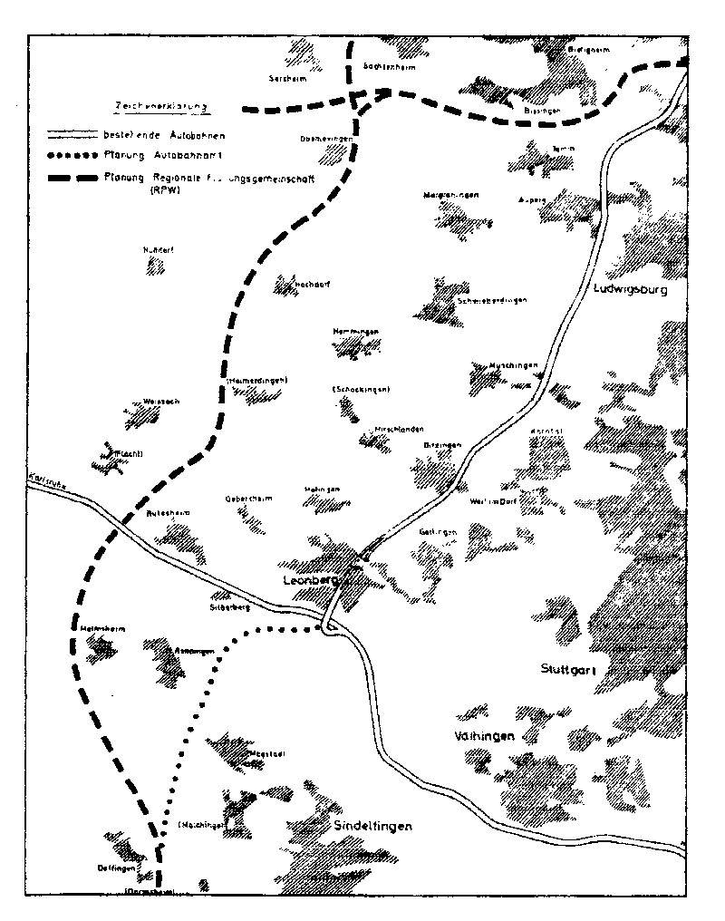
The Regional Planning Authority Württemberg Center (RPW) designed in 1969 a plan that should run a second parallel motorway between Heilbronn and Stuttgart, in which the at Pleidelsheim branches from the stock street, about Markgröningen , Hemmingen and Rutesheim motorway Karlsruhe-Munich leads and then in runs in a curve via Renningen to Sindelfingen . There it should meet a continuation of the existing route coming from the Stuttgart motorway triangle and then continue as a single route towards Singen.
A plan study by Karl Schaechterle comes from the same year , who envisaged a route east of Leonberg in the form of a modified Feinau route . The existing route on Engelberg was to be stepped down to the B 295, which would have created both a motorway passing Leonberg to the east and a bypass road to the east. The newly planned Stuttgart motorway junction was initially planned as a turbine design, later as a clover-leaf cross with tangent solutions.
A plan from 1970 envisaged deviating from the existing road south of the Stuttgart-Zuffenhausen junction and leading the motorway past Leonberg to the west. Accordingly, a new motorway junction with the Karlsruhe – Munich motorway (since 1975 BAB 8 ) would also have been created west of Leonberg . This western bypass Leonberg , like the Silberberg route on which it is based, was essentially based on an earlier plan to lead the B 295 out of the Leonberg urban area as a western bypass.
Since no agreement could be reached on the exact route during the 1970s, the project was postponed until 1985, in favor of a six-lane expansion of the Stuttgart-Vaihingen-Gärtringen line, the section was finally abandoned. As a result, the BAB 831 between the former Stuttgart-Vaihingen interchange and the Herrenberg interchange was rededicated as BAB 81. Furthermore, all junctions were given new names: the Herrenberg junction became the Gärtringen junction, the Stuttgart-Vaihingen junction became the Stuttgart junction and the Stuttgart triangle became the Leonberg triangle.
Junction points to Leonberg
Immediately north of the motorway triangle there was a junction on the route to Heilbronn, which was called Stuttgart-West / Leonberg and primarily served as a motorway connection to the city of Leonberg. The sequence between the junction of the ramps of the motorway triangle and the branching off of the ramps at the junction has always been unusually short, which is why conflicts arose over a very short stretch regarding lane changes and turning. In the beginning, as usual on the Reichsautobahn, there were no acceleration or deceleration lanes, but these were retrofitted in the 1960s by completely changing the lane relationships. Instead of merging the two ramps, each with one lane, to form a two-lane carriageway, all the ramps in the triangle have now been expanded with two lanes. The Munich – Heilbronn routes and vice versa were designed as continuous main lanes, so that for motorists driving from Karlsruhe in the direction of Heilbronn, a situation arose that corresponded to a driveway without an acceleration lane from the left. The traffic actually driving straight ahead had to give right of way to traffic coming from the right, which is why this driveway was also known as “Germany's only motorway stop” and the Leonberg motorway triangle was considered the most dangerous motorway junction in Germany. It was an additional problem for drivers coming from Karlsruhe to use the junction to Leonberg. For this purpose, the lane had to be changed twice within a very short distance, as the deceleration lane for the junction already began on the Munich – Heilbronn ramp.
In the 1980s, this dangerous traffic route disappeared when the Stuttgart-West / Leonberg junction was abandoned and a new junction in the form of a right-hand trumpet was created east of the triangle. Between the triangle and this new junction (called Leonberg , since 2008 Leonberg-Ost ), parallel lanes have been built so that long-distance and turning traffic do not get in each other's way. In addition, the Munich – Heilbronn ramp was rebuilt with a wider radius.
modification
Together with the six-lane expansion of the BAB 81 between the Stuttgart-Feuerbach junction and the Leonberg triangle, a complete reconstruction of the motorway triangle, which also included a change in design, was carried out. At the same time, the old uphill section including the old Engelberg tunnel was given up and replaced by a lower, six-lane route that leads through the new 2.5 km long Engelberg base tunnel. This expansion and reconstruction took place from July 1995 to August 1999, with the first tunnel tube already being put into operation in September 1998, initially for both directions of travel.
The Leonberg junction on the BAB 8 was also redesigned. The L 1187 (formerly Glemseckstraße) was relocated to the south, closer to the autobahn, and led to the extended Südrandstraße, so that the ramps of the junction no longer meet a common feeder road. Immediately to the east of the autobahn triangle, the Neue Ramtelstrasse industrial estate was built between Südrandstrasse and the old Glemseckstrasse .
The motorway triangle in its current design no longer has indirect ramps; all connections are designed as two-lane direct ramps. Although the traffic jams in the area of the motorway triangle have decreased significantly since the renovation, the section from the Leonberg triangle to the Stuttgart junction is still the busiest in Baden-Württemberg. The east direction of travel has been here since 2000 and the west direction since 2017 with four lanes in each direction.
In the course of the six-lane expansion of the BAB 8 between Karlsruhe and Stuttgart, a new Leonberg-West junction was built to the west of the triangle by 2008 , which leads from the motorway directly onto the B 295 in the direction of Calw / Renningen . The previous detour through the triangle, the Leonberg junction and the Südrandstrasse were no longer necessary. The previous Leonberg junction was renamed Leonberg-Ost .
Traffic volume
The triangle is used by around 186,000 vehicles every day, making it one of the busiest in Baden-Württemberg.
| From | To | Average daily traffic volume |
Share of heavy goods traffic |
||||
|---|---|---|---|---|---|---|---|
| 2005 | 2010 | 2015 | 2005 | 2010 | 2015 | ||
| AS Leonberg-West (A 8) | AD Leonberg | 71,100 | 84,700 | 117,500 | 13.2% | 15.3% | 14.6% |
| AD Leonberg | AS Leonberg-Ost (A 8 / A 81) | 133,000 | 147,600 | 140,500 | 13.5% | 12.6% | 13.4% |
| AS Stuttgart-Feuerbach (A 81) | AD Leonberg | 92,300 | 95,600 | 114,000 | 13.7% | 14.8% | 10.3% |
Web links
Individual evidence
- ^ AD Leonberg. (No longer available online.) Autobahn intersections & Autobahn triangles in Germany, 2011, formerly in the original ; Retrieved December 3, 2012 . ( Page no longer available , search in web archives ) Info: The link was automatically marked as defective. Please check the link according to the instructions and then remove this notice.
- ↑ RPW planning , autobahn-online.de
- ^ A 81 Leonberg - Gärtringen , autobahn-online.de
- ^ Traffic in AD Leonberg (old) , Baden-Württemberg State Archives
- ↑ Auto Motor und Sport, Issue 15/1980, pages 24–26
- ↑ Route of the A 8 in the direction of Stuttgart. In the background the new building of the AS Stuttgart / Leonberg. In the foreground, the reconstruction of the Leonberg motorway triangle , Baden-Württemberg State Archives
- ↑ Manual road traffic census 2005. (PDF) Results on federal motorways. BASt Statistics, 2007, accessed on August 22, 2018 .
- ↑ Manual road traffic census 2010. (PDF) Results on federal motorways. BASt Statistics, 2011, accessed on August 22, 2018 .
- ↑ Manual road traffic census 2015. (PDF) Results on federal motorways. BASt Statistics, 2017, accessed on August 22, 2018 .