
Egenbüttel

Egenbüttel is a district of the three districts in the Holstein community of Rellingen in the Pinneberg district . The other two districts are Rellingen-Ort and Rellingen- Krupunder . In Rellingen-Ort, the Mühlenau body of water is also known as Rellau; it flows into the Pinnau in Pinneberg and later into the Elbe .
location
Egenbüttel borders in the north and east on the municipality of Ellerbek , in the west on the district Rellingen-Ort and in the south on the districts Rellingen-Ort and Rellingen-Krupunder. The non-navigable Mühlenau (Rellau) forms - coming from Ellerbek - the natural municipal border to Ellerbek and Rellingen-Ort for a good two kilometers.
Geographical location
Egenbüttel is one of the older permanent settlements in the Rellingen parish. Its location alone gives clear indications. It rises on a ridge around which the Mühlenau (Rellau) lowland winds, structured several times. The Land Surveying Office Schleswig-Holstein in Kiel determined the following elevations around Egenbüttel: at the Rellau (Mühlenau) in Rellingen-Ort near the fork in Stawedder / Mühlenstraße 6.6 m, on the Rellinger side at the Jebbenberg upstream 6.4 m, at the Mühlenau between Egenbüttel and Ellerbek 7.6 m, on the ridge near Keller 12.8 m, on the Hempberg of the Egenbüttel ridge even 13.8 m. The ascent to Egenbüttel from Rellingen on Hamburger Straße and on Halstenbeker Weg from Mühlenstraße is striking.
history
The place is mentioned in documents in the 14th century through the appearance of a Fridrich Edinckbuttell (also: Fredrich Eidenbuttell ) in Rellingen in 1564, as well as when the chapter village Rellingen was sold in 1564 through the mention of Heinrich Hatken, Claus Warneke, Hartich Hartken, as well as those liable to pay interest in Egenbüttel also the mention of Carsten Edenbüttel in 1590 in and near Wedel as a family name. The oldest written mention of Egenbüttel and the origin of the name kept research busy for a long time.
Based on the resolutions of the municipal council of Rellingen on September 25, 1973 and the council of Egenbüttel on September 20, 1973, a boundary change agreement was agreed on October 5, 1973. Egenbüttel has been part of the municipality of Rellingen since January 1st, 1974.
Hallway names
When the official street names were introduced, the municipality of Egenbüttel used the old field names exactly or in slightly amended or modified form. The following old field names have been preserved in the street names until 2007: Am Hasloegen, Bitzkamp, Bosselwisch, Hempberg, Heidkoppel, Im Dorfe, Kellerstraße, Kurtenkamp, Pütjenweg, Redwisch.
The five land maps of the Egenbüttel district issued by the Pinneberg land registry office also contain the land names mentioned in addition to the land dimensions. The following list contains all the field names drawn. It can be assumed, however, that the field names on the maps with new building areas disappeared with the entries for new buildings, especially for the Rechterallee, Moorweg, Hans-Reuman-Straße and Hermann-Löns-Weg area.
- District Egenbüttel No. 17; Corridor 1: Bosselwisch, Gaselwisch, Mühlenhoffwisch, Grotwisch, Egenbüttelerwisch, Heidhorst, Isch, Ubhoff, Ohlenbossel, Bosselwiek, Surbrock, Diekreyn, Kattenkeil, Hasreyn, Weide
- District Egenbüttel No. 17; Corridor 2: In the village
- District Egenbüttel No. 17; Corridor 3: Redwisch, Welchkamp, Stinop, Melandswisch, Groten Stücken, Bitzkamp, Karberg, Unfeld, Unfelds Heide, Heidkoppel
- District Egenbüttel No. 17; Hallway 4: Billors Bruch, Nettelkrog, Ruhwisch, Alt Egenbütteler Gehege, Schulkoppel, Horstkoppel, Keller, Hasfeld, Harstenberg, Kurtenkamp, In der Heide, Poggenpulwisch, Tröntmoor, Hembergs Wischen, Kamp, Kamp, Ohl-Moor, Ohlen Kamp, Hemberg
- District Egenbüttel No. 17; Corridor 5: Hasreyn, Kohlhof, Hasloegen, Püttgen, Lehmkamp, Lüttwisch, Grotwisch, Dehlwischen, Neuwisch, Egenbütteler Moor
Population development
| year | 1803 | 1890 | 1895 | 1900 | 1905 | 1910 | 1919 | 1925 | 1933 | 1937 | 1939 | 1946 | 1948 | 1950 | 1956 | 1961 | 1970 | 1973 |
|---|---|---|---|---|---|---|---|---|---|---|---|---|---|---|---|---|---|---|
| Number (on December 31st) | 210 | 282 | 294 | 319 | 351 | 413 | 406 | 419 | 546 | 607 | 611 | 1127 | 1211 | 1312 | 1443 | 1577 | 2083 | 2389 |
After the voluntary merger of Egenbüttel and Rellingen on January 1, 1974, the population development of Egenbüttel is managed together with Rellingen .
traffic
Local public transport
Egenbüttel is in the area of the public transport offered by the Hamburger Verkehrsverbund . The VHH bus line 195 leads from the district town of Pinneberg ( S-Bahn station line S3) via Rellingen through Egenbüttel and on via Ellerbek- Süd, the Schnelsen stop on the AKN line A1, the center of Hamburg-Schnelsen to the Niendorf Nord underground station the subway - U2 . Bus route 185 runs from Pinneberg via Rellingen to the Halstenbek S-Bahn station through western Egenbüttel (Halstenbeker Weg). There you can change to bus line 184, should you go to Elbgaustr. want to continue. In the opposite direction from Elbgaustr, you should of course first use bus line 184 then bus line 185.
On school days, bus routes 781 are also operated through Egenbüttel, Ellerbek and Rellingen and 595 from Tangstedt and Rellingen to the school center .
Streets
Egenbüttel is conveniently located to the federal highway 23 and the federal highway 7 , both highways can be reached in just a few kilometers. In town, Egenbüttel is accessed through Pinneberger Strasse and Kellerstrasse. The Pinneberger Straße , which was expanded around 1905, runs from the east of Egenbüttel in (Hamburg-) Schnelsen to Rellingen-Ort in the west.

Pinneberger Strasse 33

Pinneberger Strasse 53 Hof Timm> Hatje> Quast

Pinneberger Strasse 119 Hof Reumann> Nagel

Pinneberger Strasse 121 Hof Reumann


- The back road leading from Ellerbek coming south across the intersection basement / Pinneberger road up to the Federal Highway 23 to the junction Halstenbek / Krupunder .
- In Fasanenstraße , the road signs at the Fasanenstraße 31 junction and Am Moorbad are unusual. As the following photo shows, the entrance to No. 31, the former Egenbüttel mud bath, is marked as a private road. The street sign Am Moorbad, on the other hand, is a normal street sign. Only behind building 31 does a narrow paved path lead to the twelve parcels of the oldest garden settlement in Egenbüttel, which are hidden in the forest. Some of the settlement houses are also unusual.
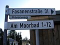
Follow the signs to Fasanenstraße
Am Moorbad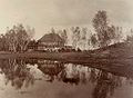
Kurhaus Bad Egenbüttel Bathing establishment
on the right of the Rodelberg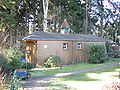
Garden settlement Am Moorbad, former AKN wagon


economy
The agricultural arable land that has been typical of Egenbüttel for centuries has disappeared; with a few exceptions, it has been converted into tree nursery areas.
- A large, modern and flexibly managed farm with dairy farming is located on the Kirchenstieg . The farm shows that a farm can still support a family in the fifth generation. 180 dairy cows form the basis. In addition, 42 white noble goats deliver raw milk, which is processed into fresh milk and cheese products in the company's own dairy . The direct marketing of the milk and cheese products in a family farm shop on Pinneberger Straße supplement sales.

- The nurseries are of very different sizes. It ranges from small family businesses to modern and flexible tree nurseries in the Pinneberg district. The company, which was founded in 1953 on Dorfstraße, produces after its move to Pinneberger Straße in 1999 on 13 hectares of container space according to the new environmentally friendly and technical knowledge. In a closed rainwater recovery system, the resulting water, both irrigation water and rainwater, is collected in a water storage tank and from there trickled onto the cultivated area using watering car technology. The move of the tree nursery from Dorfstrasse to Pinneberger Strasse not only had advantages for the tree nursery business, a new residential area was created on the abandoned production areas on the newly built streets Im Dorfe and Am Dorfteich .
- The Egenbüttel industrial park between Hermann-Löns-Weg and Hans-Reumann-Straße was built on a 30-hectare deforestation site. In the economic hardship of the immediate post-war period, the forest was cut down and burned. The last remains of the forest had already disappeared in 1946 and 50 settler families lived on the site, scattered across the entire area. In 1956, the economic and development company of the Pinneberg district began negotiating with all parties involved, and the development of the settlement area began as early as the summer of 1957.
The factories located in this area made Egenbüttel a partner for the neighboring larger Rellingen. As early as 1967, Egenbüttel had 50% more companies and more than four times as many employees than Rellingen. In 1974 the municipalities of Rellingen and Egenbüttel merged.
Resident companies on Industriestrasse
In 1967, 67 companies from very different trades had already settled in the industrial area on Industriestrasse. Some of the establishments achieved far-reaching importance. The following are listed as an example: Lackfa , Chemische Fabrik; Hoffmann , cardboard factory; Wickersheim , machine factory; Ottleuchten , lighting fixture factory ; Car flight , aviation and auto industry security devices; Hofmann , machine factory; Schulenburg , furniture store.
School system and further education


The Egenbüttel school center on Schulweg is the fourth school location in the history of the Egenbüttel schools. No details are known about the first school. It is known that the residents of Egenbüttel approached the landdrosten Otto Carl von Callenberg (1686–1759) in Pinneberg in 1721 with the request to be able to employ a school owner. Before that there was no school in the village. The second school, also single-class, was still in Hollow Oak No. 7 in 2008. It was built in 1882 using materials from the older school building. In the following years this school proved to be in need of repair and too small, so in 1906 the third school, now three-class, was built at Pinneberger Strasse 54. But not all school-age children in Egenbüttel were allowed to attend this school. In the address book Schiller-Tietz from 1904 it says: School community: Landgemeinde Egenbüttel (with the exception of the property of the farmer HH Rechter in Hempberg, which belongs to the school community Krupunder). The old school was empty for several years in 2007 and is no longer in use. In 1915 an extension was necessary. After the strong population increase after the Second World War (refugees from the eastern areas) and the baby boomers in the post-war period , further expansions followed: in 1960 with the "bungalow classes", in 1970 with another five classrooms in the west wing and 1972 with another six classrooms in the east wing.
Before the incorporation in 1974, both municipalities had already worked together in the field of education, the school association of the municipalities of Rellingen and Egenbüttel was founded in December 1970. The school association, which the Tangstedt community also joined in December 1971 and which was therefore renamed the Rellingen-Egenbüttel-Tangstedt school association, established the school center with a secondary school, a secondary school and a special school (school for people with learning disabilities). An OGTS (open all-day school) has also been offered since 2003.
societies
- Sport-Club Egenbüttel from 1953 eV : The SC Egenbüttel has a sports area with five grass pitches, equipped with escape lighting systems, a sports center and changing rooms.
- Football club Eintracht Rellingen from 1987 eV On May 20, 1987 the club was founded under the name FC Egenbüttel. A few months later, at an extraordinary general meeting, it was decided to rename the club Eintracht Rellingen from 1987 eV to avoid confusion with SC Egenbüttel.
- Tennisclub Egenbüttel eV In 1967 the club was founded with the facilities on Moorweg. The club has seven outdoor courts and its own three-field hall. The club has around 400 members with a youth share of around 25%.

- Fire brigade The first fire brigade of the Egenbüttel fire brigade was built in 1889 near today's memorial, Am Gedenkstein. It was only a small house, it was enough to accommodate the one hand pressure syringe that had to be transported to the scene of the fire by horse and cart. The Egenbüttel volunteer fire brigade was only founded in 1942 in the Hohle Eiche inn. In 1946 a new fire station was built on Pinneberger Strasse next to the school , which in turn had to give way in 1977 for an enlarged fire station for three vehicles.
Former clubs
- Rifle club Egenbüttel & the surrounding area founded in 1886
Flag rifle club for Egenbüttel and the surrounding area

Schützenzelt around 1936

Former bullet trap from the shooting range, 2008

Emergency money, motif on the back

Emergency money, shooting range and target stand

Emergency money, target position

Emergency money, target position


In 2008, only the bullet trap, the so-called "lead mountain", from the end of the shooting range remained from the shooting range and the shooting range at the Egenbütteler Gehölz.
- Comrades-in-arms and warrior association Egenbüttel founded in 1910
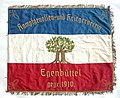
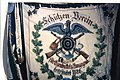
Comrades-in-arms and warrior club front

Comrade-in-arms and warrior club back

Back section


The comrades-in-arms and warriors' association came into being after the establishment of the German Reich from 1871 until the beginning of the First World War in 1914. In Rellingen the associations of this direction are called: Association of the Military Brotherhood of Rellingen and the Surrounding Area, Comrades-in-arms Association from 1870 to 1871 for Rellingen and Guard Corps of the Pinneberg district , Rellingen headquarters. The original flag of the Egenbüttel comrades-in-arms was still preserved in 2008.
Description of the flag: One side is blue-white-red striped lengthways with the words "Kampfgenossen- und Kriegerverein" on the blue, a stylized double oak on the white and the words "Egenbüttel founded 1910" on the red stripe. The other side of the flag shows a female figure on a white background, above it in a semicircle the lettering: "In loyalty firm, loyal in the storm!"
Religions
Located within sight of the Rellingen Church , Egenbüttel has belonged to the Rellingen parish since the Rellingen parish was founded. In 1260, pastor Eylardus was mentioned for the first time as a documented pastor. The parish originally encompassing 150 km² was divided into two parishes in 1768; Egenbüttel then belonged to parish II. In 1958, Bönningstedt, Ellerbek and Egenbüttel-Siedlung became their own parish. The parish of Rellingen in 2008 included Rellingen-Ort, a sub-area of Egenbüttel and Tangstedt with the Wulfsmühle. The name Egenbüttel was mentioned in 1797/1798 during the tumult on the occasion of the implementation of the new agende (order of worship). Members of the parish, a Johann Hinrich Pein from Egenbüttel was mentioned by name, resisted the new Bible texts. Johann Hinrich had pain after the investigations and negotiations even in the detention room .
The nearest Catholic parishes are in Halstenbek and Pinneberg.
War memorial
The war memorial for those who fell in the wars from Egenbüttel is on Pinneberger Straße in the Am Gedenkstein complex. In the complex a stone cross with the inscription “Those who died for us”, next to it, stone tablets embedded in the floor with the years of the wars from 1870 to 1871, 1914 to 1918 and 1939 to 1945. Also a stone name for the only war dead from 1870 / 71 HH Westphalen and a large stone with the inscription 1914/1918 (Iron Cross) As a lasting memory of our sons who died in the World War. Including the following 16 names of the war dead of the First World War .

War memorial
at the memorial stone
War memorial on 50 Pfg. Emergency banknote 1921

War memorial 1870/71 and 1914/18 on the old syringe house


The large stone with the fallen from the First World War, together with the memorial stone 1870/1871, was part of a memorial erected after the First World War in the style of the 1920s at approximately the same place next to the old syringe house. In 1956 the memorial was redesigned for the first time. In 1962, after the curve of Pinneberger Strasse was straightened, the entire facility was once again generously redesigned. The entire complex was brought forward, a paved path was laid and trees and ornamental shrubs were planted.
Natural monuments

Hollow Oak Natural Monument, photo taken in 2003

Natural monument Pinneberger Strasse 48

Natural monument
Pinneberger Strasse 38


The nature conservation authority has listed three natural monuments in the list of natural monuments in the Pinneberg district for Egenbüttel:
- "Hohle Eiche", English oak on the street "Hohle Eiche", in front of house no. 2; the German Tree Archives give the age of this tree as 450 to 600 years. This makes it one of the oldest oaks in Schleswig-Holstein . With a circumference of 8½ meters, it is also the second thickest oak in Schleswig-Holstein.
- Pedunculate oak; Pinneberger Strasse 48; No. 1 to the left of the house in front of the shed, No. 2 to the right of the house.
- Pedunculate oak; Pinneberger Straße 38, No. 1/2 at the entrance to the farm, No. 3 in the back garden next to the pond on Halstenbeker Weg.
Landscape protection area LSG 06 Düpenau-Mühlenau
The landscape protection area Düpenau and Mühlenau has existed since 2004 for the area of the municipalities of Schenefeld , Halstenbek , Pinneberg, Rellingen, Rellingen-Egenbüttel, Ellerbek, Bönningstedt and Hasloh . In Egenbüttel, it affects roughly the Mühlenau area from the Kirchenstieg-Mühlenaubrücke to the Mühlenaubrücke Pinneberger Strasse / Hamburger Strasse in Rellingen-Ort. The landscape protection area is not accessible via a hiking trail along the Mühlenau Rellau-Düpenau.

The mill bridge on Bosselwisch
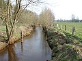
The Mühlenau, view from the Bosselwischbrücke upstream

Meadows on the Bosselwisch

Bend on the Kirchenstieg


Regular events
The Egenbüttel volunteer fire brigade has been setting up the Easter fire on the Halstenbeker Weg / Hempbergstrasse meadow for years . The events in Rellingen-Ort are actively supported by the Egenbüttel district.
Personalities
Honorary citizen
- A street was named after Hans Reumann , a farmer and local politician. Hans Reumann was born on January 4, 1892. He became a farmer and ran his own farm in the formerly independent municipality of Egenbüttel. Since 1921 he was a member of the community council of his home community and became its community leader and mayor. He joined the NSDAP at an early age, but did not express himself in their favor after taking power and was therefore forced to resign on July 20, 1935. More than ten years later, after the end of the war and Nazi rule, Hans Reumann was appointed mayor by the British military government. In the late summer of 1946, elections for the municipal council took place again, after which Hans Reumann was re-elected mayor and chairman of the municipal council. In 1951 he was re-elected. During this time he was also head of the Bönningstedt office for several years , to which the Egenbüttel community belonged at that time. Hans Reumann was one of the founders of the CDU in Egenbüttel. After his sudden death on December 17, 1954, his son Karl-Heinz succeeded him on May 13, 1955. As early as 1948, Hans Reumann was honored for his meritorious work by the fact that the street between Pinneberger Strasse and Moorweg was named after a resolution by the Egenbüttel municipal council.
politics
- Albert Hatje , tree nurser and local politician. Stations were among other things finance committee chief and deputy mayor in Egenbüttel, parliamentary group leader of the CDU in Rellingen and since November 1989 mayor of the tree nursery community. Hatje's talent for balance, his humor and his commitment to volunteering were recognized. The tree nursery supervisor has been a member of the Egenbüttel volunteer fire brigade since 1941, is an honorary judge at the administrative court and was awarded the Federal Cross of Merit in 1988 for his commitment .
Others
- Magda Butenschön , b. Helms (1914–2007), war widow, tree nurser. At this point Magda Butenschön represents other war widows from Egenbüttel with a similar fate. In 2006, the project group Women and Home created the résumé of Magda Butenschön as a war widow with five children and the management of a tree nursery for over 30 years in its publication Portraits Rellinger Frauen .
- Hermann Rechter (1872–1945), farmer; Rechterallee was named after him. H. Rechter comes from the Rechter Stammhof Pinneberger Straße 38, corner of Halstenbeker Weg. He himself runs his own farm, which his father built for him on the other corner of Halstenbeker Weg at Pinneberger Straße 34. He doesn't like traditional agriculture, he sells his farm and runs a pig farm on the neighboring property in cooperation with the Rellinger Mühle. Later, together with a butcher from Halstenbek, he bought the blind farmer Stoldt's land southwest of Pinneberger Strasse. He parceled out the site and made it accessible from Pütjenweg with an unpaved road. Rechter himself called his dead straight, birch-planted field path Rechterallee. This name was retained even after the site was sold to the municipality of Egenbüttel and the development in the 1930s, so to speak in recognition of his many years of voluntary work as the head of the municipality of Egenbüttel.
literature
- Manfred Otto Niendorf: Chronicle Rellingen. 1992, DNB 930359259 .
- Wilhelm Ehlers: History and folklore of the Pinneberg district. 1922, DNB 579329305 .
- Mariechen Heitmann: Material for those interested in local history about the village of Egenbüttel. 1995.
- Volunteer Fire Brigade Egenbüttel (Ed.): 50 years 1942–1992 Volunteer Fire Brigade Egenbüttel.
- Walter Koop: How Karl-Bunje-Straße got its name. 1992, DNB 930349091 .
- Economic u. Development company of the Pinneberg district (ed.): Economic development in the district area, review and outlook. 1967, DNB 740734822 .
- SC Egenbüttel (Ed.): SC Egenbüttel from 1953 eV 1953-2003.
- Community of Rellingen (Ed.): Portraits of Rellinger women. 2006.
- Wieland Witt, Reinhold Miller: Rellingen. Sutton, Erfurt 2005, ISBN 3-89702-896-4 . (The archive images series)
Web links
Individual evidence
- ↑ Franz Stieler: Egenbüttels name and oldest documented mention. In: Yearbook for the Pinneberg District 1975 , p. 168.
- ^ Federal Statistical Office (ed.): Historical municipality directory for the Federal Republic of Germany. Name, border and key number changes in municipalities, counties and administrative districts from May 27, 1970 to December 31, 1982 . W. Kohlhammer, Stuttgart / Mainz 1983, ISBN 3-17-003263-1 , p. 183 .
- ↑ Manfred Otto Niendorf: Chronicle Rellingen. 1992, p. 74.
- ↑ Economic u. Development company of the Pinneberg district (ed.): Economic development in the district area, review and outlook. 1967, p. 16.
- ^ Johanna Ways: The Church Rellingen. 1990, pp. 122, 85.
- ↑ Walter Koop: How Karl-Bunje-Straße got its name. 1992.
- ↑ Pinneberg district, Environment Service, Nature Conservation Authority, Directory of Natural Monuments, downloadable PDF file
- ↑ Walter Koop: How Karl-Bunje-Straße got its name. 1992, p. 150.
- ↑ Pinneberger Zeitung of May 25, 2005.
- ↑ Portraits of Rellinger women. P. 46.
Coordinates: 53 ° 39 ′ 4 ″ N , 9 ° 51 ′ 5 ″ E