Tangstedt (Pinneberg district)
| coat of arms | Germany map | |
|---|---|---|

|
Coordinates: 53 ° 41 ′ N , 9 ° 51 ′ E |
|
| Basic data | ||
| State : | Schleswig-Holstein | |
| Circle : | Pinneberg | |
| Office : | Pinnau | |
| Height : | 7 m above sea level NHN | |
| Area : | 12.52 km 2 | |
| Residents: | 2252 (Dec. 31, 2019) | |
| Population density : | 180 inhabitants per km 2 | |
| Postal code : | 25499 | |
| Area code : | 04101 | |
| License plate : | PI | |
| Community key : | 01 0 56 047 | |
| Office administration address: | Hauptstrasse 60 25462 Rellingen |
|
| Website : | ||
| Mayoress : | Henriette Krohn ( CDU ) | |
| Location of the municipality Tangstedt in the Pinneberg district | ||
Tangstedt ( Low German : Tangsteed ) is a municipality in the Pinneberg district in Schleswig-Holstein . Occasionally it is confused with the place of the same name in the Stormarn district , which is only 16 km away, east of Norderstedt. Wulfsmühle is in the municipality.
Geography and traffic
The municipality of Tangstedt borders the city of Pinneberg and the municipality of Borstel-Hohenraden in the west, the city of Quickborn in the north, the municipalities of Hasloh and Bönningstedt in the east and the municipalities of Ellerbek and Rellingen in the south .
The river Pinnau flows through Tangstedt, which has its source in Henstedt-Ulzburg and flows into the Elbe.
Tangstedt is located on a county road between Rellingen and Hasloh (Dorfstrasse). The highways 23 and 7 are a short distance away. Tangstedt is connected to local public transport via the HVV bus routes 395 and 595 .
history
Tangstedt is one of the oldest settlements in this area. The first documentary mention took place in 1242 in the state archive under "Tangstede". For a long time it was assumed that the name goes back to the proper name "Thanco". More recent findings assume that the name Tangstedt finds its justification in the terrain formations characteristic of Tangstedt of an ice age sander that surrounds several small moors .
The Wulfsmühle is also documented as early as 1382. Tangstedt has been part of the parish of Rellingen since the 14th century. A school is first mentioned in 1719.
Some streets have been named after the deceased mayors. For example, there is a Jacob-Behrmann-Weg or a Bürgermeister-Eggerstedt-Weg. A street was also named after the former schoolmaster Hermann Krohn.
Since 2003, the population of Tangstedt has grown by around ten percent due to two construction areas. These are the 'Kleine Twiete' with eleven houses and the 'Steenacker' in the center of the village with 70 houses. Tangstedt consists almost exclusively of single-storey single houses. A commercial area is being planned at the entrance to the village.
politics
Community representation
Result of the local elections on May 26, 2013
| Political party | percent | Seats |
|---|---|---|
| FDP | 41.2% | 5 |
| CDU | 35.0% | 5 |
| SPD | 23.7% | 3 |
coat of arms
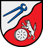
Blazon : “Divided obliquely to the left in a wave cut. Above, in silver, a left-turned, oblique left-facing set of blue pliers, below, in red, a silver millstone, next to it an upright silver wolf. "
Culture and sights
One of the most beautiful excursion destinations is the Wulfsmühle with a larger lake and a golf course. In Tangstedt there are many beautiful farms and a riding stable. An extensive network of paths offers many opportunities for long walks through the spacious landscape.
economy
The most important industry in Tangstedt is agriculture and forestry. There are also good craft and trading companies in the community. In 2006, the planning of a 40,000 m² industrial area began.
Web links
Individual evidence
- ↑ North Statistics Office - Population of the municipalities in Schleswig-Holstein 4th quarter 2019 (XLSX file) (update based on the 2011 census) ( help on this ).
- ↑ Schleswig-Holstein topography. Vol. 9: Schönberg - Tielenhemme . 1st edition Flying-Kiwi-Verl. Junge, Flensburg 2007, ISBN 978-3-926055-91-0 , p. 328 ( dnb.de [accessed on August 6, 2020]).
- ↑ Schleswig-Holstein's municipal coat of arms


