
Holm (Pinneberg district)
| coat of arms | Germany map | |
|---|---|---|
_Wappen.png)
|
Coordinates: 53 ° 37 ' N , 9 ° 40' E |
|
| Basic data | ||
| State : | Schleswig-Holstein | |
| Circle : | Pinneberg | |
| Office : | Geest and Marsch Südholstein | |
| Height : | 11 m above sea level NHN | |
| Area : | 16.05 km 2 | |
| Residents: | 3234 (Dec. 31, 2019) | |
| Population density : | 201 inhabitants per km 2 | |
| Postal code : | 25488 | |
| Area code : | 04103 | |
| License plate : | PI | |
| Community key : | 01 0 56 028 | |
| Office administration address: | Amtsstrasse 12 25436 Moorrege |
|
| Website : | ||
| Mayor : | Uwe Hüttner ( CDU ) | |
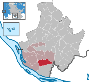
| Location of the municipality of Holm in the Pinneberg district | ||
  |
||

Holm is a municipality in the Pinneberg district in the south of Schleswig-Holstein .
Geography and traffic
In addition to the town center, the municipality of Holm consists of the two districts Katharinenhof and Holmerberg.
In the eastern part of the municipality there is the Holmer Sandberge recreation area with a 20 m high elevation. The Elbmarsch begins west of Holm. The Buttermoor / Butterbargsmoor nature reserve is also located in Holm.
Via the federal highway 431 running directly through Holm, the connection to the community is next to Wedel u. a. to the next larger cities Uetersen and Hamburg (Rissen) (each seven kilometers away), Pinneberg and Tornesch (each ten kilometers away). Holm also borders the communities of Hetlingen, Heist and Appen. In Wedel there is a connection to the Hamburg S-Bahn . Three bus lines connect Holm with the S-Bahn station in Wedel, further bus connections go to Norderstedt Mitte, Quickborn, Uetersen, Elmshorn and the communities in the area.
history
Holm was first mentioned in a document dated April 29, 1255. In the centuries that followed, different spellings were used for the village of Holm: Holne, Hollen and Holling. The place name comes from Low German and means "hole" or "pile of grass".
Holm is located on Ochsenweg , an old military road that was used for ox drifts. Since the beginning of the 15th century, large herds of cattle were driven from Jutland via Holm to Wedel.
There is evidence of a village school in Holm for 1708. In 1716, 80 children went to school in winter, and in summer they were assigned to field and gardening. Compulsory schooling - for a fee - only existed from 7 to 10 years of age. After that the children up to the age of 13 had to attend catechism lessons for two days in winter and daily lessons again in the winter before confirmation.
The Voluntary Fire Brigade Holm was founded on April 1st, 1890.
Since 1991 the community has been in partnership with the town of Rehna in Mecklenburg-Western Pomerania.
politics
Community representation
Results of the local elections on May 26, 2013 and May 6, 2018
| Political party | 2013 percent |
Seats | 2018 percent |
Seats |
|---|---|---|---|---|
| CDU | 71.3% | 12 | 53.8% | 9 |
| SPD | 28.7% | 5 | 20.8% | 4th |
| Green | --- | --- | 25.4% | 4th |
coat of arms
Blazon : “In red a twisted, Bronze Age golden arm ring. In the front upper corner a golden oak leaf, in the back a golden ear. "
Culture and sights
- Local history museum with a shoemaker's workshop, furnishings and documents from private households, schools and public institutions. The museum is housed in a Gulf stud house built around 1700 , which was moved to its current location in the mid-19th century.
- Part of the annual Hamburg Cyclassics . This is also the turning point of the route, from where you are now on your way back to Hamburg.
- Thanksgiving festival in autumn with associated parade.
Infrastructure
- Heinrich Eschenburg Elementary School
- Evangelical Noahs Ark Kindergarten
- DRK kindergarten
- Wittsmoor NDR measuring and receiving station
Sports
- TSV spar with u. a. of the baseball team Holm Westend 69ers
- Sports facilities: two soccer fields, baseball field, tennis facility, archery range, sports hall
- Kessy sports center with tennis courts, squash court and bowling alley as well as soft darts and pool facilities
- Hamburg-Holm Golf Club
Churches
- Ecclesiastical community center from 1971 of the North Elbian Evangelical Lutheran Church
- Church at Roland in Wedel in the Blankenese parish
Personalities associated with Holm
- Hans Schmidt-Isserstedt (1900–1973), conductor
- Arnim Dahl (1922-1998), stunt performer
- Wilfried Gunkel (1930–2005), marine biologist
- Günther Baechler (* 1953), Swiss diplomat, political scientist and painter
- Tim Linde (* 1976), songwriter
- Carsten-Otto Nagel (* 1962), show jumper
literature
- Holm planning group: 725 years of Holm. History and stories of our hometown. Uetersen 1980.
- Wilfried Gunkel , Jürgen Koch: 750 years of Holm - our village: 1255–2005. A chronicle . Holm 2004. ISBN 978-3-00-013705-1 .
Web links
Individual evidence
- ↑ North Statistics Office - Population of the municipalities in Schleswig-Holstein 4th quarter 2019 (XLSX file) (update based on the 2011 census) ( help on this ).
- ↑ City map Holm city map service Germany
- ↑ Schleswig-Holstein topography. Vol. 4: Groß Sarau - Holstenniendorf . 1st edition Flying-Kiwi-Verl. Junge, Flensburg 2004, ISBN 978-3-926055-75-0 , p. 353 ( dnb.de [accessed on May 3, 2020]).
- ↑ Schleswig-Holstein topography. Vol. 4: Groß Sarau - Holstenniendorf . 1st edition Flying-Kiwi-Verl. Junge, Flensburg 2004, ISBN 978-3-926055-75-0 , p. 353 ( dnb.de [accessed on May 3, 2020]).
- ↑ Schleswig-Holstein's municipal coat of arms
- ↑ Tsv: TSV Holm 1910 e. V. - Home. Retrieved February 28, 2018 .
Cities: Barmstedt | Elmshorn | Pinneberg | Quickborn | Schenefeld | Tornesch | Uetersen | Fronds . Other municipalities: Appen | Bevern | Bilsen | Bokel | Bokholt hand grinder | Bönningstedt | Borstel-Hohenraden | Brande-Hörnerkirchen | Bull hollows | Ellerbek | Ellerhoop | Great North End | Great Offenseth-Aspern | Halstenbek | Haselau | Haseldorf | Hasloh | Heede | Heidgraben | Heist | Heligoland | Shirtingen | Hetlingen | Spar | Klein Nordende | Klein Offenseth-Sparrieshoop | Kölln-Reisiek | Kummerfeld | Langeln | Lutzhorn | Bog rain | Neuendeich | Osterhorn | Prisdorf | Raa-Besenbek | Rellingen | Seester | Starfish | Seeth-Ekholt | Tangstedt | Westerhorn .