
Bog rain
| coat of arms | Germany map | |
|---|---|---|

|
Coordinates: 53 ° 40 ′ N , 9 ° 40 ′ E |
|
| Basic data | ||
| State : | Schleswig-Holstein | |
| Circle : | Pinneberg | |
| Office : | Geest and Marsch Südholstein | |
| Height : | 8 m above sea level NHN | |
| Area : | 10.76 km 2 | |
| Residents: | 4445 (Dec. 31, 2019) | |
| Population density : | 413 inhabitants per km 2 | |
| Postal code : | 25436 | |
| Area code : | 04122 | |
| License plate : | PI | |
| Community key : | 01 0 56 036 | |
| LOCODE : | DE 63L | |
| Office administration address: | Amtsstrasse 12 25436 Moorrege |
|
| Website : | ||
| Mayor : | Karl-Heinz Weinberg ( CDU ) | |
| Location of the municipality of Moorrege in the Pinneberg district | ||
  |
||


Moorrege ( Low German : Moorreeg ) is a municipality in the Pinneberg district in Schleswig-Holstein . The districts of Bauland, Heidrege, Klevendeich, Moorrege and Oberglinde are part of today's municipal area. The districts of Bauland and Klevendeich are located in the Haseldorfer Marsch , while the districts of Heidrege, Moorrege and Oberglinde are located on the Geest and have increasingly merged with one another in the course of the 20th century.
Geography and traffic
Moorrege lies on the Pinnau and borders the city of Uetersen and the communities of Appen , Heist , Haselau and Neuendeich . The federal road 431 and the historic Ochsenweg run through the community. Moorrege is directly connected to the towns of Pinneberg , Uetersen, Wedel and Elmshorn as well as to the Haseldorfer Marsch by several bus lines .
history
Moorrege was first mentioned in a document in 1285. At that time the place was called "Mor", which probably refers to the boggy environment. The name Moorrege means "row of houses on the moor". The early Bronze Age burial mound De Danzenbarg on the Pinnau is one of the earliest indications of settlement in the municipality.
In the Uetersener church book the place is mentioned in 1712 as "Mohrrege".
On April 1, 1948, the Uetersen Land Office was founded and renamed the Moorrege Office in 1953 . At the same time the administration was moved to Moorrege.
The St. Michaelis Church in Moorrege was built in 1960.
Economic history
1803 Moorrege had 578 inhabitants; their number rose to around 1700 by 1910. The main reason for this was the creation of jobs by the Alsen cement factory, which was located here until 1930. This was also taken over by the Glinder Tonkuhlen, from which clay was extracted as early as the 13th century. Therefore, there was a brick factory for a long time . Two shipyards on the Pinnau, one of them the Johan Hinrich Jacobs shipyard from 1898 to 1960, were located in Moorrege for a long time. One of the largest ewer , the " Petrine ", was launched in 1909 at the JH Jacobs shipyard in today's Werftweg with a payload of 64 tons . The connection with the water is still maintained by the coastal shipping companies based here.
politics
Community representation
Result of the local elections on May 26, 2013
| Political party | percent | Seats |
|---|---|---|
| CDU | 56.7% | 9 |
| SPD | 28.3% | 5 |
| Alliance 90 / The Greens | 15.0% | 3 |
coat of arms
Blazon : “Divided diagonally to the left by a silver wave bar of black and green. In the front five 2: 2: 1 set golden balls, behind a fallen golden anchor under a four-spoke golden machine wheel. "
The introduction of the coat of arms for the municipality of Moorrege was approved on October 28, 1993 by the Ministry of the Interior of Schleswig-Holstein . The black color shows the reference to the original name "row of houses on the moor". The five spheres symbolize the districts of Bauland, Heidrege, Klevendeich, Moorrege and Oberglinde. The Pinnau river - located on the outskirts of Moorrege - is represented by the wave bar. The green color symbolizes agriculture, the anchor the centuries-old shipping and the machine wheel industry as a branch of business.
Culture and sights
A special eye-catcher with the large park is still the country house built by Detlef Lienau around 1870 , the so-called Schloss Düneck . The second oldest functional swing bridge in Germany is also located in the Klevendeich district, the Klevendeich swing bridge from 1887, which crosses the Pinnau River.
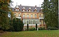
Düneck Castle , street view, built in 1871

Front view
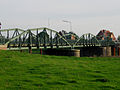
Swing bridge in Klevendeich , built in 1887


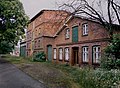
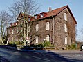
Other historical buildings

Former school on Klinkerstrasse, built in 1896
Former mill, building no longer exists
Former dormitory of the Alsen-Werke, built in the 19th century.

Villa Witt, built around 1900

Villa on Moorreger Chaussee

House on Wedeler Chaussee


Facilities
In 1957 a new elementary school was built, which has been used as a primary school since 1974 . At the same time, the school center with secondary and secondary school was built on the Himmelsbarg.
economy
The facilities of Nordmark-Pharma and Feldmuehle Uetersen GmbH (formerly Stora Enso ) in Uetersen are important employers in the community. There are also several car dealerships and a national tool grinding shop in the industrial area .
Sons and daughters of the church
- August Landmesser (1910–1944), shipyard worker who was the only one in a large crowd to refuse to give the Hitler salute at a party in 1936
- Alma Würth (1913–2006), entrepreneur
Web links
- Moorrege community at the Moorrege office
Individual evidence
- ↑ North Statistics Office - Population of the municipalities in Schleswig-Holstein 4th quarter 2019 (XLSX file) (update based on the 2011 census) ( help on this ).
- ↑ Schleswig-Holstein topography. Vol. 6: Kronprinzenkoog - Mühlenrade . 1st edition Flying-Kiwi-Verl. Junge, Flensburg 2006, ISBN 978-3-926055-85-9 , pp. 340 ( dnb.de [accessed July 29, 2020]).
- ↑ Schleswig-Holstein's municipal coat of arms
Cities: Barmstedt | Elmshorn | Pinneberg | Quickborn | Schenefeld | Tornesch | Uetersen | Fronds . Other municipalities: Appen | Bevern | Bilsen | Bokel | Bokholt hand grinder | Bönningstedt | Borstel-Hohenraden | Brande-Hörnerkirchen | Bull hollows | Ellerbek | Ellerhoop | Great North End | Great Offenseth-Aspern | Halstenbek | Haselau | Haseldorf | Hasloh | Heede | Heidgraben | Heist | Heligoland | Shirtingen | Hetlingen | Spar | Klein Nordende | Klein Offenseth-Sparrieshoop | Kölln-Reisiek | Kummerfeld | Langeln | Lutzhorn | Bog rain | Neuendeich | Osterhorn | Prisdorf | Raa-Besenbek | Rellingen | Seester | Starfish | Seeth-Ekholt | Tangstedt | Westerhorn .