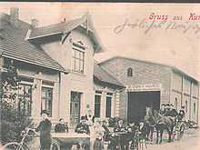
Kummerfeld
| coat of arms | Germany map | |
|---|---|---|

|
Coordinates: 53 ° 42 ' N , 9 ° 47' E |
|
| Basic data | ||
| State : | Schleswig-Holstein | |
| Circle : | Pinneberg | |
| Office : | Pinnau | |
| Height : | 13 m above sea level NHN | |
| Area : | 6.5 km 2 | |
| Residents: | 2346 (Dec. 31, 2019) | |
| Population density : | 361 inhabitants per km 2 | |
| Postal code : | 25495 | |
| Area code : | 04101 | |
| License plate : | PI | |
| Community key : | 01 0 56 032 | |
| LOCODE : | DE KFD | |
| Office administration address: | Hauptstrasse 60 25462 Rellingen |
|
| Website : | ||
| Mayoress : | Erika Koll ( SPD ) | |
| Location of the municipality of Kummerfeld in the Pinneberg district | ||
Kummerfeld is a municipality in the Pinneberg district in Schleswig-Holstein.
Geography and traffic
Kummerfeld is located north of the district town of Pinneberg on the federal motorway 23 and is still bordered by the municipalities of Borstel-Hohenraden in the east, Prisdorf in the south-west, Tornesch in the north-west and Ellerhoop in the north. Kummerfeld is integrated into the HVV via bus route 185 . The Bilsbek flows in the northwest of the municipality.
history
The first written mention of Kummerfeld took place in 1320. The place was originally called Cummervelde or Kummeruelde , which probably means little land . The population has increased in recent years. While it was still 1996 in 2006, it is now 2366.
politics
Community representation
Result of the local elections on May 26, 2013
| Political party | percent | Seats |
|---|---|---|
| SPD | 52.8% | 7th |
| CDU | 47.2% | 6th |
coat of arms
Blazon : “Divided by a raised, slanted silver wavy bar of blue and red. Above a golden ear of corn next to a golden acorn, below a left-facing silver wolf sitting on a silver stone with an open mouth. "
Attractions
The cooking oak , one of the distinctive and old tree specimens in southern Schleswig-Holstein and the largest and most imposing natural monument in the Pinneberg district.
economy
The originally agricultural community has now developed into a typical residential community in the Hamburg area. To the west of the autobahn is an industrial park with companies from various industries, which is currently being expanded.
Sports
Kummerfeld has extensive sports grounds west of the autobahn. In addition to several football and tennis courts, a beach volleyball court, a streetball facility and an athletics facility, the park-like area has also been home to a modern three-field sports hall since 2007. The cricket department, which was founded in 2016, currently plays in the German Bundesliga. She became Bundesliga North champion in the 2019 season.
Culture
From 2006 to 2017, the arable festival took place annually in September on the community's sports field, which was held by a registered association. In front of around 2000 visitors, both lesser-known local bands and nationally / internationally successful bands played on two days.
Personalities
People who were born in Kummerfeld or who worked here.
- Johann Georg Kuhlmann (born April 9, 1812), religious socialist and confederate
- Wilhelm Ferdinand Kuhlmann (born May 20, 1821), robbery murderer
- Hanns-Jürgen Bohland, Mayor from 1988 to 1990 and from 1994 to 2013. First and so far only honorary citizen of the Kummerfeld community.
Web links
Individual evidence
- ↑ North Statistics Office - Population of the municipalities in Schleswig-Holstein 4th quarter 2019 (XLSX file) (update based on the 2011 census) ( help on this ).
- ↑ Schleswig-Holstein topography. Vol. 6: Kronprinzenkoog - Mühlenrade . 1st edition Flying-Kiwi-Verl. Junge, Flensburg 2006, ISBN 978-3-926055-85-9 , pp. 62 ( dnb.de [accessed June 26, 2020]).
- ↑ Schleswig-Holstein's municipal coat of arms


