
Little north end
| coat of arms | Germany map | |
|---|---|---|

|
Coordinates: 53 ° 44 ' N , 9 ° 39' E |
|
| Basic data | ||
| State : | Schleswig-Holstein | |
| Circle : | Pinneberg | |
| Office : | Elmshorn country | |
| Height : | 10 m above sea level NHN | |
| Area : | 10.79 km 2 | |
| Residents: | 3337 (Dec. 31, 2019) | |
| Population density : | 309 inhabitants per km 2 | |
| Postal code : | 25336 | |
| Area code : | 04121 | |
| License plate : | PI | |
| Community key : | 01 0 56 029 | |
| LOCODE : | DE 63A | |
| Office administration address: | Lornsenstrasse 52 25335 Elmshorn |
|
| Website : | ||
| Mayor : | Adolf Luitjens (WG) | |
| Location of the municipality of Klein Nordende in the Pinneberg district | ||
  |
||


Klein Nordende is a municipality southwest of Elmshorn in the Pinneberg district in Schleswig-Holstein . It extends on both sides of the "Geestkante" running in north-south direction, on which the Elbmarsch rises to the higher Geest .
Geography and traffic
Klein Nordende is located south of Elmshorn in a rural area. Federal highway 431 runs to the west . The Hamburg-Altona-Kiel railway line (built as the Christian VIII. Ostseebahn ) runs further east over the municipality.
history
The rural community of Klein Nordende was established in 1867 as part of the administrative reform in Schleswig-Holstein, which had recently become a Prussian province , in the area of several villages and field marks. Until well into the 20th century, larger parts of the municipal area were characterized by shifting dunes , then reforested wasteland. The population was around 500 in the beginning.
Outsourcing
With effect from April 1, 1938, the small district of Lieth, in which 61 percent of the population lived, was separated and incorporated into the town of Elmshorn. Conversely, Klein Nordende received part of the dissolved Hainholz municipality, with the result that the area increased significantly on balance.
On January 1, 1974 and January 1, 1982, areas with then almost 300 inhabitants (1974) and about 100 inhabitants (1982) were assigned to the city of Elmshorn .
church
The Evangelical Lutheran Bugenhagen Church was built in 1983. The community initially represented parish III of the Elmshorn Ansgarkirche, but was later spun off and has been independent since then.
politics
Community representation
From 1923 (at the latest) to March 1933, Klein Nordende's municipal council was headed by the SPD mayor Gustav Schäfer. Only Günter Hell (WG, 1966 to 1998) achieved a longer term of office. Hans Barthold Schinckel (also WG) was mayor from 2003 to 2018. He was replaced on June 14th of the same year by Adolf Luitjens (community of voters).
- Greens : 2
- SPD : 3
- Flat share : 9
- CDU : 3rd
Result of the local elections of 2018:
| Political party | percent | Seats |
|---|---|---|
| Voting Community Klein Nordende (WG) | 52.4% | 9 |
| SPD | 17.2% | 3 |
| CDU | 15.8% | 3 |
| Green | 14.6% | 2 |
coat of arms
Blazon : "In red over a silver quarry stone, an upright silver asparagus bunch and two silver leafed cattails next to each other."
Parish partnership
Since 1990 there has been a partnership with the municipality of Zempin on Usedom .
Sports
At the foot of the "Butterberg" is the multi-discipline sports club SpVgg. Lieth resident. The clubhouse is located in the Elmshorn area, as are the tennis courts. The first men's soccer team plays in the (unofficially so-called) "Waldstadion" in Klein Nordende.
Brick factory and lime pit
history
During the construction of the Altona-Kiel railway line in 1844, layers of earth from the Permian were exposed at what is now the Lieth block , including red clays from Rotliegend . As a result, the Rotenlehm brickworks was established there in 1847 , which mined the clays and processed them into bricks . Lime was found during clay mining , which has also been mined since 1925. The brickworks ceased operations in 1965, and lime mining in the Liether pit continued until 1986. The old brick buildings are not listed and are subject to ongoing decay.
The Liether Kalkgrube today
After the economic exhaustion of the deposits, the mine was preserved as a geological monument and nature reserve . The Elmshorn salt dome below the region pushed layers of earth over 200 million years old to the surface, making them easy to examine. In the middle of the pit, the limestone cap covering the salt dome is visible, which gave the pit its current name; in the edge areas there is a smaller lignite seam . The Liether Kalkgrube offers the best insight into geological formations in Northern Europe between Sweden and the Harz Mountains. Fossils and tool finds suggest that the area was already used as a storage place by Stone Age hunters and gatherers around 10,000 to 14,000 years ago.
Since the pit is located on the historic Ochsenweg , it is a popular stage for bike tours. In addition to a circular hiking trail around the pit, a geo-ecological nature trail leads to the center of the pit.
More Attractions
- The Norddeutsche Rundfunk regularly records the program Lüders Krug on a farm in Klein Nordende that has been converted into a café, the Töverhuus .
- The Dorfstrasse, an avenue with trees on both sides, is also worth seeing.

Liether Kalkgrube
exposed rocks from the Permian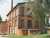
Former Rotenlehm brickworks
company building (2000)
The Töverhuus
broadcasting location of the NDR
Memorial stone to the deepest earth drilling in Germany
at the end of the 19th century


literature
- Peter Danker-Carstensen: Local history Klein Nordende , published by the municipality, Schleswig 1997.
Web links
Individual evidence
- ↑ North Statistics Office - Population of the municipalities in Schleswig-Holstein 4th quarter 2019 (XLSX file) (update based on the 2011 census) ( help on this ).
- ↑ Peter Danker-Carstensen: Ortsgeschichte Klein Nordende , published by the community, Schleswig 1997, p. 19.
- ↑ See Peter Danker-Carstensen: Ortsgeschichte Klein Nordende , published by the municipality, Schleswig 1997, esp.p. 102.
- ^ Federal Statistical Office (ed.): Historical municipality directory for the Federal Republic of Germany. Name, border and key number changes for municipalities, counties and administrative districts from May 27, 1970 to December 31, 1982 . W. Kohlhammer GmbH, Stuttgart / Mainz 1983, ISBN 3-17-003263-1 , p. 183 and 813 .
- ↑ Minutes of meetings of the Klein Nordende municipal council (available from 1923)
- ^ Homepage of the voter community , accessed on July 13, 2018
- ^ Website of the community , accessed on August 7, 2018
- ↑ Schleswig-Holstein's municipal coat of arms
- ↑ See map at Europlan Online , accessed on July 29, 2017.
Cities: Barmstedt | Elmshorn | Pinneberg | Quickborn | Schenefeld | Tornesch | Uetersen | Fronds . Other municipalities: Appen | Bevern | Bilsen | Bokel | Bokholt hand grinder | Bönningstedt | Borstel-Hohenraden | Brande-Hörnerkirchen | Bull hollows | Ellerbek | Ellerhoop | Great North End | Great Offenseth-Aspern | Halstenbek | Haselau | Haseldorf | Hasloh | Heede | Heidgraben | Heist | Heligoland | Shirtingen | Hetlingen | Spar | Klein Nordende | Klein Offenseth-Sparrieshoop | Kölln-Reisiek | Kummerfeld | Langeln | Lutzhorn | Bog rain | Neuendeich | Osterhorn | Prisdorf | Raa-Besenbek | Rellingen | Seester | Starfish | Seeth-Ekholt | Tangstedt | Westerhorn .