
Neuendeich
| coat of arms | Germany map | |
|---|---|---|

|
Coordinates: 53 ° 41 ′ N , 9 ° 36 ′ E |
|
| Basic data | ||
| State : | Schleswig-Holstein | |
| Circle : | Pinneberg | |
| Office : | Geest and Marsch Südholstein | |
| Height : | 0 m above sea level NHN | |
| Area : | 8.54 km 2 | |
| Residents: | 507 (Dec. 31, 2019) | |
| Population density : | 59 inhabitants per km 2 | |
| Postal code : | 25436 | |
| Primaries : | 04122, 04125 | |
| License plate : | PI | |
| Community key : | 01 0 56 037 | |
| LOCODE : | DE 63M | |
| Office administration address: | Amtsstrasse 12 25436 Moorrege |
|
| Website : | ||
| Mayor : | Reinhardt Pliquet ( SPD ) | |
| Location of the community of Neuendeich in the Pinneberg district | ||
  |
||

Neuendeich ( Neendiek in Low German ) is a municipality in the Pinneberg district in Schleswig-Holstein . Neuendeich was first mentioned in a document in 1303.
Geography and traffic
Neuendeich lies on the Elbe and one of its tributaries, the Pinnau . The community is largely in the Seestermüher Marsch , a small part is in the Haseldorfer Marsch . Oberrecht, Rosengarten, Schadendorf and Schlickburg as well as Binnendiek and Esch are in the municipality.
Neuendeich can be reached via the federal highway 23 from Hamburg to Elmshorn . The federal road 431 runs east of the municipality from Wedel via Uetersen to Elmshorn.
politics
Community representation
Result of the local elections on May 6, 2018
| Political party | percent | Seats |
|---|---|---|
| SPD | 52.98% | 5 |
| CDU | 47.02% | 4th |
coat of arms
Blazon : “Divided diagonally to the left by a silver wavy bar with green borders on the right. Above in gold the red gable side of a farmhouse with boarded gable, below in green a silver pollarded willow. "
Attractions
The swing bridge built in 1887 leads over the Pinnau to Klevendeich . She is the second oldest functional swing bridge in Germany and stands as cultural monument under monument protection . The bridge connects the Haseldorfer Marsch with the Seestermüher Marsch.
Further sights:
- Former school on the Pinnaudeich
- Former ferry house on the Pinnaudeich
- Numerous thatched farmhouses that are typical of the marshland region
- Cultural and historical cycle path through Neuendeich
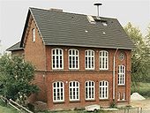
Old school

Former ferry house in
1987
Rose garden, farmhouse

Rose garden, farmhouse

Rosengarten 13, homestead


supporting documents
- ↑ North Statistics Office - Population of the municipalities in Schleswig-Holstein 4th quarter 2019 (XLSX file) (update based on the 2011 census) ( help on this ).
- ↑ Schleswig-Holstein topography. Vol. 7: Munkbrarup - Pohnsdorf . 1st edition Flying-Kiwi-Verl. Junge, Flensburg 2006, ISBN 978-3-926055-88-0 , p. 50 ( dnb.de [accessed on July 21, 2020]).
- ↑ Schleswig-Holstein's municipal coat of arms
Web links
Cities: Barmstedt | Elmshorn | Pinneberg | Quickborn | Schenefeld | Tornesch | Uetersen | Fronds . Other municipalities: Appen | Bevern | Bilsen | Bokel | Bokholt hand grinder | Bönningstedt | Borstel-Hohenraden | Brande-Hörnerkirchen | Bull hollows | Ellerbek | Ellerhoop | Great North End | Great Offenseth-Aspern | Halstenbek | Haselau | Haseldorf | Hasloh | Heede | Heidgraben | Heist | Heligoland | Shirtingen | Hetlingen | Spar | Klein Nordende | Klein Offenseth-Sparrieshoop | Kölln-Reisiek | Kummerfeld | Langeln | Lutzhorn | Bog rain | Neuendeich | Osterhorn | Prisdorf | Raa-Besenbek | Rellingen | Seester | Starfish | Seeth-Ekholt | Tangstedt | Westerhorn .