
Starfish Trouble
| coat of arms | Germany map | |
|---|---|---|

|
Coordinates: 53 ° 42 ' N , 9 ° 34' E |
|
| Basic data | ||
| State : | Schleswig-Holstein | |
| Circle : | Pinneberg | |
| Office : | Elmshorn country | |
| Height : | 1 m above sea level NHN | |
| Area : | 23.35 km 2 | |
| Residents: | 899 (Dec. 31, 2019) | |
| Population density : | 39 inhabitants per km 2 | |
| Postcodes : | 25371, 25377 | |
| Area code : | 04125 | |
| License plate : | PI | |
| Community key : | 01 0 56 045 | |
| LOCODE : | DE 63E | |
| Office administration address: | Lornsenstrasse 52 25335 Elmshorn |
|
| Website : | ||
| Mayor : | Thorsten Rockel ( SPD ) | |
| Location of the municipality of Seestermühe in the Pinneberg district | ||
  |
||

Seestermühe ( Low German : Seestermüh ) is a municipality in the Pinneberg district in Schleswig-Holstein .
Geography and traffic
The community is located directly on the Elbe between the Krückau and Pinnau rivers in the middle of the Seestermüher Marsch , one of the four Elbe marshes . The uninhabited Elbe island Pagensand also belongs to the municipality . Neighboring communities directly adjacent are Neuendeich and Seester , the next larger cities Elmshorn and Uetersen .
history
Seestermühe was first mentioned in a document in 1141 and originally belonged to the diocese of Bremen, which from 1105 settled Dutch immigrants who were supposed to promote the cultivation of the flooded land. The name of the community is derived from today's river “Krückau”, which is composed of the former river name “Seester” and the old German name “muthe” for mouth, so Seestermühe is the place at the mouth of the Seester . One church was destroyed by a storm surge in 1357 and never rebuilt; In the name of the church, the Haseldorfer landowners determine what is happening in today's municipality and the parish was added to the Seester parish . Before 1550, the Haseldorf estate was divided and Seestermühe became an independent estate district. A mansion was built. After the moat had been dug on today's Schulstrasse, construction of the Seestermüher Castle began around 1700 and the lime tree avenue that still exists today was laid out. Whether there was a French-style garden at that time cannot be clearly established to this day. The not yet completed castle burned to the ground in 1713. In 1752 the von Ahlefeldt family's estate was heavily in debt and was sold to the Count von Kielmansegg - only the Elbe island of Pagensand was awarded to the Danish crown and later sold to private customers. It was not until 1899 that the Seestermüher estate was abolished, two years later the Pagensand island was sold to the city of Hamburg and incorporated into Seestermühe in 1928.
politics
Community representation
- SPD : 5
- Flat share : 3
- CDU : 3rd
Result of the local elections on May 26, 2013
| Political party | percent | Seats |
|---|---|---|
| SPD | 47.3% | 5 |
| CDU | 28.3% | 3 |
| Voting Community Seestermühe (WG) | 24.4% | 3 |
coat of arms
Blazon : "In silver, a Göpelschauer slightly shifted forward from the center of the shield with a black thatched roof, red walls and green gate, accompanied at the top right by an oblique blue wavy bar, on the left by an outward-facing, naturally tinged chess flower ."
tourism

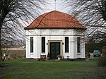
Like most communities in the Elbmarschen, Seestermühe is a popular destination for day-trippers and cyclists, especially in the summer months. The vastness of the outer dike area between the two dike lines along the Elbe is ideal for hikers, inline skaters and cyclists. Sights of the community include a double avenue of lime trees around 700 meters between the estate and the tea house of the von Kielmansegg family , the village museum " Göpelschauer " with its historical equipment and tools from the fields of agriculture, fishing and handicrafts, and the former charity from 1830 (now houses a kindergarten and apartments). With the nature reserve " Eschschallen in Seestermüher Vorland ", Seestermühe has a unique reserve for rare plants and animals, but is not allowed to be entered to protect them.
- Gut Seestermuhe

Kielmansegg manor house
Teahouse of the Kielmansegg estate

Former charity, now a kindergarten, community office and part of the village community center


education
The children of the community attend the Protestant kindergarten "Unter dem Regenbogen", which is housed in the premises of the former school in Schulstrasse under the sponsorship of the Seester parish. There has been no primary school in Seestermühe since 1974. The primary school in Seester, which is run by the Seestermüher Marsch school association, is visited. Secondary schools of all branches can be found in the neighboring towns of Elmshorn and Uetersen.
Personalities
- Friedrich von Rönne (1798–1865), Prussian diplomat, lawyer and ambassador
- Hermann Hüllmann (1861–1937), German shipbuilding engineer
- Magreta Brandt (1915–1992), Low German writer
- Doris Kunstmann (* 1944), German actress, moved into a thatched-roof house in Seestermühe in 1983 and lived there for many years
- Tony Sheridan (1940-2013), well-known rock'n'roll singer and composer, as well as friend of ex-Beatle Paul McCartney , lived in sea troubles
- Jan Georg Schütte (* 1962), German actor and director, lives in Seestermühe
particularities
Seestermühe has also become famous for an important apple variety, the Seestermüher lemon apple .
literature
- Peter Danker-Carstensen: Village history Seestermühe. A community in the Elbmarsch. Husum Druck- und Verlagsgesellschaft, Husum 2002, ISBN 3-89876-095-2
Web links
Individual evidence
- ↑ North Statistics Office - Population of the municipalities in Schleswig-Holstein 4th quarter 2019 (XLSX file) (update based on the 2011 census) ( help on this ).
- ↑ Schleswig-Holstein topography. Vol. 9: Schönberg - Tielenhemme . 1st edition Flying-Kiwi-Verl. Junge, Flensburg 2007, ISBN 978-3-926055-91-0 , p. 77 ( dnb.de [accessed on July 31, 2020]).
- ↑ Schleswig-Holstein's municipal coat of arms
Cities: Barmstedt | Elmshorn | Pinneberg | Quickborn | Schenefeld | Tornesch | Uetersen | Fronds . Other municipalities: Appen | Bevern | Bilsen | Bokel | Bokholt hand grinder | Bönningstedt | Borstel-Hohenraden | Brande-Hörnerkirchen | Bull hollows | Ellerbek | Ellerhoop | Great North End | Great Offenseth-Aspern | Halstenbek | Haselau | Haseldorf | Hasloh | Heede | Heidgraben | Heist | Heligoland | Shirtingen | Hetlingen | Spar | Klein Nordende | Klein Offenseth-Sparrieshoop | Kölln-Reisiek | Kummerfeld | Langeln | Lutzhorn | Bog rain | Neuendeich | Osterhorn | Prisdorf | Raa-Besenbek | Rellingen | Seester | Starfish | Seeth-Ekholt | Tangstedt | Westerhorn .