
Langeln (Holstein)
| coat of arms | Germany map | |
|---|---|---|

|
Coordinates: 53 ° 48 ' N , 9 ° 51' E |
|
| Basic data | ||
| State : | Schleswig-Holstein | |
| Circle : | Pinneberg | |
| Office : | Rantzau | |
| Height : | 19 m above sea level NHN | |
| Area : | 10.28 km 2 | |
| Residents: | 601 (Dec. 31, 2019) | |
| Population density : | 58 inhabitants per km 2 | |
| Postal code : | 25485 | |
| Area code : | 04123 | |
| License plate : | PI | |
| Community key : | 01 0 56 034 | |
| Office administration address: | Chemnitzstrasse 30 25355 Barmstedt |
|
| Website : | ||
| Mayor : | Bernhard Froh (BWG) | |
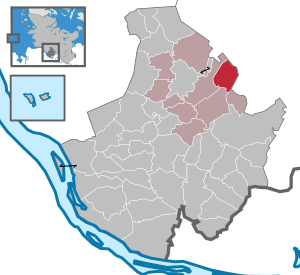
| Location of the municipality of Langeln in the Pinneberg district | ||
  |
||

Langeln is a municipality in the Pinneberg district in Schleswig-Holstein . On the Butterberg, Auf dem Beck, Langelner Heidkaten, Vossmoor and Hohenufer are in the municipality.
geography
The community is located in the northeast of the Pinneberg district, about five kilometers east of Barmstedt . The Krückau flows through the municipality.
The place is on the sandy geest . The landscape was shaped during the last ice age .
The districts of Vossmoor and Heidkaten are to the north of the historic center, and the Hohenufer district to the west.
history
Finds from the Bronze Age show that the area of today's Langeln was settled before the turn of the century . Langeln was first mentioned in a document on November 30, 1564.
In a deed of purchase with which the droste Hans Barner had bought the parishes of Barmstedt and Rellingen from the Hamburg cathedral chapter for 6,000 Lübsche Marks on behalf of Count Otto von Schauenburg-Pinneberg in 1564 , u. a. the maintenance of the annual rye deliveries of the resident subjects, including the Langelner, regulated.
politics
Community representation
- BWG : 5
- CDU : 4th
Result of the local elections on May 26, 2013
| Political party | be right | percent | Seats |
|---|---|---|---|
| Civil voter community Langeln (BWG) | 797 | 60.5% | 5 |
| CDU | 521 | 39.5% | 4th |
| Turnout: 63.8% |
coat of arms
Blazon : “Divided into green, blue, green and red by a sloping silver wave bar and a silver post to the left. Above right four floating silver burial mounds, one larger in the upper right corner, three smaller ones along the wavy bar, below a silver plow. "
The green base color and the wheelless plow are supposed to reflect the agriculture that has influenced and influenced the design of the village over generations and still today. The sloping wave bar indicates the strongly meandering Krückau, which was created during the last Ice Age. The bar, directed from top to bottom, represents the trunk road built by order of the Danish king in 1832, today's federal road 4. The four barrows indicate an early settlement. The colors blue, white and red should reflect the affiliation to Schleswig-Holstein .
Partnerships
There is a partnership with the village of the same name Langeln in Saxony-Anhalt .
Culture and sights
Cultural monuments
There are numerous barrows in the municipality that have their origins in the Bronze Age ( Langeln burial ground ).
Culture
Numerous groups and associations actively shape village life, u. a .: Voluntary fire brigade, local farmers' association, hunting community, Emsig Sparklub, civil voter association BWG, CDU local association, crawling group, women's group, Langelner senior citizens, religious discussion group.
Sports
In 2004 a new soccer field was put into operation. There is no local sports club (although a club called SC Langeln took part in the game in 1949/50 , but it was last in the lowest league and then withdrew), so the offers of the clubs in the neighboring communities are used. These include in particular the TuS Shirtingen-Bilsen, FC Heede, BMTV Barmstedt and SSV Rantzau Barmstedt .
Regular events
Langeln Open Air takes place annually in summer (July / August). Bands from the fields of punk, rock and heavy play live on two stages for fifteen hours.
economy
Agriculture : The townscape and landscape are shaped by several high-performing farms. The keeping of dairy cattle, including forage production, and the cultivation of grain and rapeseed dominate. Corn is increasingly not only grown as fodder, but also used in nearby biogas plants to generate energy. There are also several craft and other businesses in the village.
Transport and infrastructure
State road 75 runs in an east-west direction. At the “Zur Hoffnung” junction, it crosses federal road 4. The Quickborn (A 7) motorway junction is about 10 km and the Tornesch (A 23) junction is about 14 km Distance. The A 20 is to be built a few kilometers north in the direction of Bad Bramstedt . The Langeln (Holst) stop is on the Elmshorn – Bad Oldesloe railway line . The Hamburg Airport is located about 28 km away.
education
Kindergarten and elementary school are in Shirtingen . Secondary schools are mostly attended in Barmstedt .
literature
- Chronicle of the municipality of Langeln. 1992
Web links
Individual evidence
- ↑ North Statistics Office - Population of the municipalities in Schleswig-Holstein 4th quarter 2019 (XLSX file) (update based on the 2011 census) ( help on this ).
- ↑ Schleswig-Holstein topography. Vol. 6: Kronprinzenkoog - Mühlenrade . 1st edition Flying-Kiwi-Verl. Junge, Flensburg 2006, ISBN 978-3-926055-85-9 , pp. 90 ( dnb.de [accessed June 26, 2020]).
- ^ Thomas Klink: Home Association: Barmstedts Birth Certificate | shz.de. Retrieved January 6, 2020 .
- ↑ Schleswig-Holstein's municipal coat of arms
Cities: Barmstedt | Elmshorn | Pinneberg | Quickborn | Schenefeld | Tornesch | Uetersen | Fronds . Other municipalities: Appen | Bevern | Bilsen | Bokel | Bokholt hand grinder | Bönningstedt | Borstel-Hohenraden | Brande-Hörnerkirchen | Bull hollows | Ellerbek | Ellerhoop | Great North End | Great Offenseth-Aspern | Halstenbek | Haselau | Haseldorf | Hasloh | Heede | Heidgraben | Heist | Heligoland | Shirtingen | Hetlingen | Spar | Klein Nordende | Klein Offenseth-Sparrieshoop | Kölln-Reisiek | Kummerfeld | Langeln | Lutzhorn | Bog rain | Neuendeich | Osterhorn | Prisdorf | Raa-Besenbek | Rellingen | Seester | Starfish | Seeth-Ekholt | Tangstedt | Westerhorn .