
Great north end
| coat of arms | Germany map | |
|---|---|---|

|
Coordinates: 53 ° 42 ' N , 9 ° 39' E |
|
| Basic data | ||
| State : | Schleswig-Holstein | |
| Circle : | Pinneberg | |
| Office : | Geest and Marsch Südholstein | |
| Height : | 7 m above sea level NHN | |
| Area : | 5.64 km 2 | |
| Residents: | 800 (Dec. 31, 2019) | |
| Population density : | 142 inhabitants per km 2 | |
| Postal code : | 25436 | |
| Area code : | 04122 | |
| License plate : | PI | |
| Community key : | 01 0 56 016 | |
| Office administration address: | Amtsstrasse 12 25436 Moorrege |
|
| Website : | ||
| Mayoress : | Ute Ehmke (GuB'82) | |
| Location of the community of Groß Nordende in the Pinneberg district | ||
  |
||


- Dorfstrasse 93 Photo: 1997
Groß Nordende ( Low German : Groten Noordinn ) is a municipality in the Pinneberg district in Schleswig-Holstein . The community consists of the districts Lander, Krull and Strohsack.
Geography and traffic
Groß Nordende is on the edge of the Seestermüher Marsch on the federal highway 431 north of Uetersen . The municipality is connected to Elmshorn, Uetersen and Wedel and thus to the greater Hamburg area by regular bus services in the Hamburg Transport Association. Direct neighboring cities and communities are Uetersen, Neuendeich , Seester , Klein Nordende and Heidgraben .
history
Groß Nordende used to be a settlement that formed in the north of Uetersen . Groß Nordende was first mentioned in 1584. From 1787, Groß Nordende belonged to the Uetersen District Bailiwick, which in 1835 was divided into three districts. Including the Groß Nordend district, as a result of which the community enjoyed a high reputation as a district administration and a certain degree of independence. The community had to take part in several wars and in 1735 the people of the Geestland had to earn their living as day laborers. At that time, the cowherd was a kind of "official" and enjoyed a certain reputation in the villages, especially since he replaced the veterinarian as an expert on cattle diseases and medicinal herbs. He presumably also treated the residents according to the same “recipes”. After the division of the “Almende” and the rise of agriculture, the office of community pastor gradually came to an end.
politics
Community representation
Since the local elections in 2008, the community of voters GuB'82 has five and the AKWG four seats in the community council.
coat of arms
Blazon : “Divided diagonally by gold and green by a red and silver bar. Above a red wagon wheel, below a silver farmhouse with a red gable, doors and windows. "
Culture and sights
The former school building, decorated with carvings, is now used as a village community center and is a listed building. In addition, several historic farms are lined up on the B 431. The road used to be part of the Ochsenweg. The building of the former Ochsenweg jug "Strohsack" is still preserved. The road and the farmhouses are on the raised Geest on the edge of the marshes, the lands are often in the marshland.
- Historic buildings on Marschrand (Dorfstrasse)
Villa Meyn
- Villa with Art Nouveau elements
- Year of construction: 1907
- Dorfstraße 35 Photo: 1996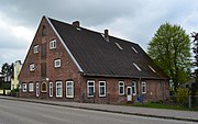
Former Strohsack restaurant
- Fachhallenhaus with warehouse
- Year of construction: 1785
- Dorfstrasse 37 Photo: 2013

So-called Möllerhof
- Small Fachhallenhaus
- Until 1923 Rauchhaus
- Dorfstraße 49 Photo: 2020
Hof Hellgrund - Koelbel
- Fachhallenhaus with extension
- Dorfstraße 67 Photo: 2007
Käckenhoff courtyard
- Fachhallenhaus with extension
- Dorfstraße 69 Photo: 2007

Former Hof Piening
- Fachhallenhaus
- Dorfstraße 71 Photo: 2007


The district of Lander is located away from the street village in the adjacent marshland. One of the oldest farmhouses in the region is located here, the Hof von Döhren from 1663.
- Courtyards in the district of Lander

Hof von Döhren
- Fachhallenhaus 11 Fach
- with a newer extension
- Year of construction: 1663
- Lander 6 Photo: 2003

Hof von Döhren
- half-timbered gable with inscription
- brick pattern
- Lander 6 Photo: 2003

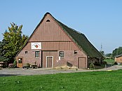
Hof Harms
- Fachhallenhaus von 10 Fach
- Half-cross house with summer wing
- Year of construction: 1717
- Lander 4 Photo: 2020


economy
The agricultural land of 560 hectares is partly in the Geest, partly in the marshland. They are used for agriculture and horticulture. While there were still 30 horticultural companies in 1945, there are still five farms today. Several farm shops and a farm café were built on the B 431. In addition, the Viking farm "Norvik", which is known nationwide, is based in Groß Nordende.
swell
- ↑ North Statistics Office - Population of the municipalities in Schleswig-Holstein 4th quarter 2019 (XLSX file) (update based on the 2011 census) ( help on this ).
- ↑ Schleswig-Holstein topography. Vol. 3: Ellerbek - Groß Rönnau . 1st edition Flying-Kiwi-Verl. Junge, Flensburg 2003, ISBN 978-3-926055-73-6 , p. 343 ( dnb.de [accessed on April 26, 2020]).
- ↑ Schleswig-Holstein's municipal coat of arms
Web links
Cities: Barmstedt | Elmshorn | Pinneberg | Quickborn | Schenefeld | Tornesch | Uetersen | Fronds . Other municipalities: Appen | Bevern | Bilsen | Bokel | Bokholt hand grinder | Bönningstedt | Borstel-Hohenraden | Brande-Hörnerkirchen | Bull hollows | Ellerbek | Ellerhoop | Great North End | Great Offenseth-Aspern | Halstenbek | Haselau | Haseldorf | Hasloh | Heede | Heidgraben | Heist | Heligoland | Shirtingen | Hetlingen | Spar | Klein Nordende | Klein Offenseth-Sparrieshoop | Kölln-Reisiek | Kummerfeld | Langeln | Lutzhorn | Bog rain | Neuendeich | Osterhorn | Prisdorf | Raa-Besenbek | Rellingen | Seester | Starfish | Seeth-Ekholt | Tangstedt | Westerhorn .